
Bilingual
En/Fa
Geographical Research is Published in both Persian and English Full-text.
Volume 40, Issue 3 (2025)
GeoRes 2025, 40(3): 203-210 |
Back to browse issues page
Article Type:
Subject:


History
Received: 2025/07/17 | Accepted: 2025/08/24 | Published: 2025/09/1
Received: 2025/07/17 | Accepted: 2025/08/24 | Published: 2025/09/1
How to cite this article
Mozafari A, Haghshenas E. Physical Development and Physical Resilience of Semnan with Emphasis on Sustainability Challenges. GeoRes 2025; 40 (3) :203-210
URL: http://georesearch.ir/article-1-1744-en.html
URL: http://georesearch.ir/article-1-1744-en.html
Download citation:
BibTeX | RIS | EndNote | Medlars | ProCite | Reference Manager | RefWorks
Send citation to:


Rights and permissions
BibTeX | RIS | EndNote | Medlars | ProCite | Reference Manager | RefWorks
Send citation to:

Authors
A. Mozafari1, E. Haghshenas *2
1- Department of Industrial Engineering, Faculty of Industrial Engineering, K.N. Toosi University of Technology, Tehran, Iran
2- Department of Environment Science, Faculty of Natural Resources and Marine Science, Tarbiat Modares University, Noor, Iran
2- Department of Environment Science, Faculty of Natural Resources and Marine Science, Tarbiat Modares University, Noor, Iran
Full-Text (HTML) (158 Views)
Background
Rapid and uneven population growth in developing countries has led to regional inequalities and extensive changes in land use. Urban sprawl has resulted in resource degradation, land wastage, and decreased spatial efficiency of cities. Therefore, examining the form and pattern of urban growth is essential for achieving sustainable and resilient development.
Previous Studies
Numerous studies have analyzed urban growth and development patterns. Glaster et al. (2001) introduce eight indicators, including density, concentration, and clustering, for analyzing urban growth. Ewing et al. (2003) have proposed a horizontal sprawl index based on residential density and accessibility. Huang et al. (2007) suggest five indicators, including compactness and complexity, to assess urban growth. Oduwaye (2009) attributes the physical instability of Lagos city to environmental, social, and managerial factors. In Iran, Azizpour et al. (2009) have examined the relationship between horizontal growth in Yazd and rural-urban migration, while Seyfoddini et al. (2023) have reported the dispersed form of Amol city. Additionally, Ebrahimzadeh & Rafiee (2009) have documented irregular urban growth in Marvdasht, and Hosseini & Ghadami (2014) highlight decreasing population density in Sabzevar. Maleki et al. (2022) also assess the spatial resilience of Izeh city and reported it to be very low.
Aim(s)
This study aims to examine the impact of various dimensions and indicators of spatial resilience in the urban area of Semnan, with a particular focus on assessing the physical (built environment) resilience of the city.
Research Type
This was an applied study
Research Society, Place and Time
This study was conducted in the urban area of Semnan. To define the study area, buffers with radii of 20 km and 50 km were drawn around the center of Semnan city using GIS, and the cities located within these buffers were identified. According to Mojtahedzadeh et al. (2022), Semnan was selected as the main city, while Sorkheh and Mahdishahr were designated as peripheral cities. The period under investigation spanned from 1986 to 2016.
Sampling Method and Number
The research population consisted of 20 individuals, including faculty members, experts, and provincial officials in the fields of urban management and disaster management, who were selected using purposive method to participate in completing the expert questionnaire.
Used Devices & Materials
In this study, GIS software was used to define the study area and to draw 20 km and 50 km radial buffers. The Analytic Hierarchy Process (AHP) was applied for weighting the criteria and subcriteria, with calculations performed in Expert Choice software. For statistical analysis of the indicators, the t-test was employed. Data related to the physical and spatial growth of the city were analyzed using the Shannon entropy and Holdern models. Qualitative data were collected through an expert questionnaire, which evaluated the indicators and sub-indicators of physical and spatial resilience across three dimensions: infrastructure, land use and geology, and environment.
Findings by Text
In this study, the development pattern of the Semnan urban area over a 30-year period (1986–2016; 1365–1395 Iranian calendar) was analyzed using the Shannon entropy and Holdern models to evaluate the stability or instability of urban physical growth. Population and spatial data were obtained from the Statistical Center of Iran and national censuses. The study area included the cities of Semnan, Mahdishahr, and Sorkheh.
According to Shannon entropy calculations for 1986 and 2016 (Tables 1 and 2), entropy values increased from -0.3105 to -0.3323, indicating a rise in urban spatial dispersion and a reduction in spatial compactness over the study period. Population and area changes (Table 3) showed that the population increased from 107,239 to 259,519, while the urban area expanded from 5,267 ha to 6,118 ha. Although urban area growth rate decreased, population density increased, and gross urban per capita area declined from 251.75 m² to 120.47 m², reflecting higher density.
Table 1. Shannon entropy calculation for the Semnan urban area in 1986
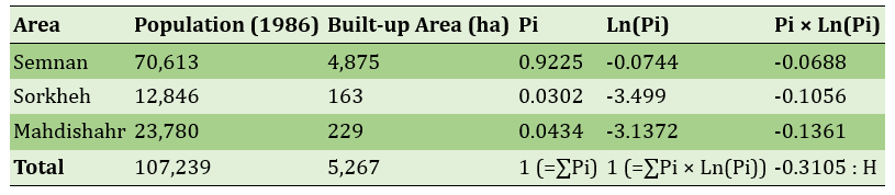
Table 2. Shannon entropy calculation for the Semnan urban area in 2016
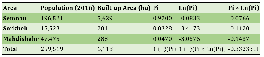
Table 3. Changes in population, urban area, and population density in the Semnan urban area (1986–2016)
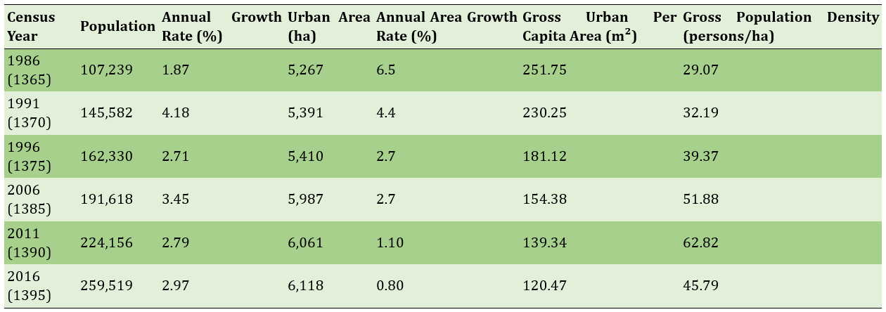
Holdern model calculations indicated that between 1986 and 2016, 6.023% of physical growth was due to population increase, while the share of horizontal expansion (urban sprawl) was negative (-5.023%), suggesting that physical growth was primarily driven by population rather than uneven horizontal expansion.
To assess physical-spatial resilience, the Analytic Hierarchy Process (AHP) was applied using Expert Choice software (Figures 1 and 2). Results showed that infrastructure had the highest weight (0.54), whereas environment had the lowest (0.13). Among sub-indicators, accessibility (0.20) scored highest, while environmental indicators scored lowest.
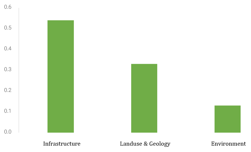
Figure 1) Weights of the main criteria determined for assessing physical resilience
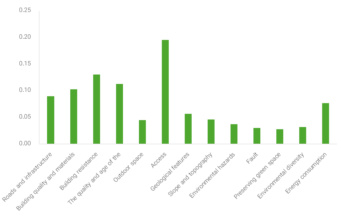
Figure 2) Weights of the sub-criteria determined Sfor assessing physical resilience
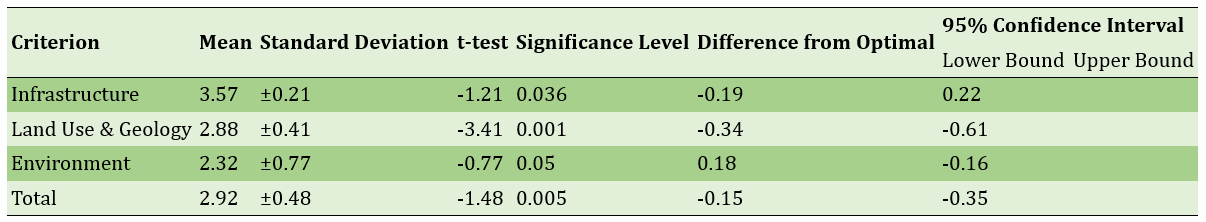
Finally, the t-test results (Table 4) indicated that the mean of all physical indicators (2.92) was below the mid-point threshold (3.5) with a significance level of <0.05, demonstrating that the physical-spatial condition of Semnan urban area is below the desirable level of resilience.
Table 4) Status of Physical-Environmental Resilience Indicators in the Semnan Urban Area
Main Comparisons to Similar Studies
The findings of this study regarding the compact and non-dispersed development pattern of the Semnan urban area align with Hamidi et al. (2015), who have interpreted the increase in Shannon entropy as an indication of reduced sprawl and improved spatial sustainability. However, in contrast to Angel et al. (2011), who have suggested that population growth generally leads to horizontal expansion, physical growth in Semnan was primarily driven by population increase with limited horizontal sprawl. The results also correspond with Nechyba & Walsh (2004), who have observed that urban density can be maintained in the absence of horizontal expansion. From the perspective of physical resilience, the findings are consistent with Maleki et al. (2022) and Shamaei et al. (2019), who have emphasized the critical role of the physical dimension in urban resilience. Conversely, the results differ from Ramezanzadeh Lasbooei & Badri (2014), who have highlighted the importance of institutional–managerial dimensions, underscoring the need for an integrated approach combining physical and managerial strategies.
Suggestions
It is recommended that urban planners in Semnan, rather than focusing solely on physical growth, prioritize sustainable development and the enhancement of service quality and infrastructure. Such measures can strengthen the city’s spatial resilience and make it more capable of withstanding future challenges, including climate change and environmental crises.
Conclusion
The physical development of the Semnan urban area over the past 30 years has been mainly driven by population growth, while the horizontal expansion of the city has played a minor role in its physical growth. The assessment of physical resilience indicators also revealed that infrastructure is in a more favorable condition compared to other criteria, whereas the environmental indicator shows the weakest status. Overall, the level of physical resilience in the area was evaluated as below average, indicating that the region lacks sufficient sustainability.
Acknowledgments: The authors express their sincere gratitude to the managers of Semnan Municipality for providing the necessary data.
Ethical Approval: No ethical approval was reported by the authors.
Conflict of Interest: This article is the result of an independent research project by the authors and has not been derived from any thesis or dissertation.
Authors’ Contributions: Mozafari A (first author), Main Researcher/Discussion Writer (75%); Haghshenas E (second author), Methodologist/Research Assistant (25%)
Funding: No funding was reported by the authors.
Rapid and uneven population growth in developing countries has led to regional inequalities and extensive changes in land use. Urban sprawl has resulted in resource degradation, land wastage, and decreased spatial efficiency of cities. Therefore, examining the form and pattern of urban growth is essential for achieving sustainable and resilient development.
Previous Studies
Numerous studies have analyzed urban growth and development patterns. Glaster et al. (2001) introduce eight indicators, including density, concentration, and clustering, for analyzing urban growth. Ewing et al. (2003) have proposed a horizontal sprawl index based on residential density and accessibility. Huang et al. (2007) suggest five indicators, including compactness and complexity, to assess urban growth. Oduwaye (2009) attributes the physical instability of Lagos city to environmental, social, and managerial factors. In Iran, Azizpour et al. (2009) have examined the relationship between horizontal growth in Yazd and rural-urban migration, while Seyfoddini et al. (2023) have reported the dispersed form of Amol city. Additionally, Ebrahimzadeh & Rafiee (2009) have documented irregular urban growth in Marvdasht, and Hosseini & Ghadami (2014) highlight decreasing population density in Sabzevar. Maleki et al. (2022) also assess the spatial resilience of Izeh city and reported it to be very low.
Aim(s)
This study aims to examine the impact of various dimensions and indicators of spatial resilience in the urban area of Semnan, with a particular focus on assessing the physical (built environment) resilience of the city.
Research Type
This was an applied study
Research Society, Place and Time
This study was conducted in the urban area of Semnan. To define the study area, buffers with radii of 20 km and 50 km were drawn around the center of Semnan city using GIS, and the cities located within these buffers were identified. According to Mojtahedzadeh et al. (2022), Semnan was selected as the main city, while Sorkheh and Mahdishahr were designated as peripheral cities. The period under investigation spanned from 1986 to 2016.
Sampling Method and Number
The research population consisted of 20 individuals, including faculty members, experts, and provincial officials in the fields of urban management and disaster management, who were selected using purposive method to participate in completing the expert questionnaire.
Used Devices & Materials
In this study, GIS software was used to define the study area and to draw 20 km and 50 km radial buffers. The Analytic Hierarchy Process (AHP) was applied for weighting the criteria and subcriteria, with calculations performed in Expert Choice software. For statistical analysis of the indicators, the t-test was employed. Data related to the physical and spatial growth of the city were analyzed using the Shannon entropy and Holdern models. Qualitative data were collected through an expert questionnaire, which evaluated the indicators and sub-indicators of physical and spatial resilience across three dimensions: infrastructure, land use and geology, and environment.
Findings by Text
In this study, the development pattern of the Semnan urban area over a 30-year period (1986–2016; 1365–1395 Iranian calendar) was analyzed using the Shannon entropy and Holdern models to evaluate the stability or instability of urban physical growth. Population and spatial data were obtained from the Statistical Center of Iran and national censuses. The study area included the cities of Semnan, Mahdishahr, and Sorkheh.
According to Shannon entropy calculations for 1986 and 2016 (Tables 1 and 2), entropy values increased from -0.3105 to -0.3323, indicating a rise in urban spatial dispersion and a reduction in spatial compactness over the study period. Population and area changes (Table 3) showed that the population increased from 107,239 to 259,519, while the urban area expanded from 5,267 ha to 6,118 ha. Although urban area growth rate decreased, population density increased, and gross urban per capita area declined from 251.75 m² to 120.47 m², reflecting higher density.
Table 1. Shannon entropy calculation for the Semnan urban area in 1986
Table 2. Shannon entropy calculation for the Semnan urban area in 2016
Table 3. Changes in population, urban area, and population density in the Semnan urban area (1986–2016)
Holdern model calculations indicated that between 1986 and 2016, 6.023% of physical growth was due to population increase, while the share of horizontal expansion (urban sprawl) was negative (-5.023%), suggesting that physical growth was primarily driven by population rather than uneven horizontal expansion.
To assess physical-spatial resilience, the Analytic Hierarchy Process (AHP) was applied using Expert Choice software (Figures 1 and 2). Results showed that infrastructure had the highest weight (0.54), whereas environment had the lowest (0.13). Among sub-indicators, accessibility (0.20) scored highest, while environmental indicators scored lowest.
Figure 1) Weights of the main criteria determined for assessing physical resilience
Figure 2) Weights of the sub-criteria determined Sfor assessing physical resilience
Finally, the t-test results (Table 4) indicated that the mean of all physical indicators (2.92) was below the mid-point threshold (3.5) with a significance level of <0.05, demonstrating that the physical-spatial condition of Semnan urban area is below the desirable level of resilience.
Table 4) Status of Physical-Environmental Resilience Indicators in the Semnan Urban Area
Main Comparisons to Similar Studies
The findings of this study regarding the compact and non-dispersed development pattern of the Semnan urban area align with Hamidi et al. (2015), who have interpreted the increase in Shannon entropy as an indication of reduced sprawl and improved spatial sustainability. However, in contrast to Angel et al. (2011), who have suggested that population growth generally leads to horizontal expansion, physical growth in Semnan was primarily driven by population increase with limited horizontal sprawl. The results also correspond with Nechyba & Walsh (2004), who have observed that urban density can be maintained in the absence of horizontal expansion. From the perspective of physical resilience, the findings are consistent with Maleki et al. (2022) and Shamaei et al. (2019), who have emphasized the critical role of the physical dimension in urban resilience. Conversely, the results differ from Ramezanzadeh Lasbooei & Badri (2014), who have highlighted the importance of institutional–managerial dimensions, underscoring the need for an integrated approach combining physical and managerial strategies.
Suggestions
It is recommended that urban planners in Semnan, rather than focusing solely on physical growth, prioritize sustainable development and the enhancement of service quality and infrastructure. Such measures can strengthen the city’s spatial resilience and make it more capable of withstanding future challenges, including climate change and environmental crises.
Conclusion
The physical development of the Semnan urban area over the past 30 years has been mainly driven by population growth, while the horizontal expansion of the city has played a minor role in its physical growth. The assessment of physical resilience indicators also revealed that infrastructure is in a more favorable condition compared to other criteria, whereas the environmental indicator shows the weakest status. Overall, the level of physical resilience in the area was evaluated as below average, indicating that the region lacks sufficient sustainability.
Acknowledgments: The authors express their sincere gratitude to the managers of Semnan Municipality for providing the necessary data.
Ethical Approval: No ethical approval was reported by the authors.
Conflict of Interest: This article is the result of an independent research project by the authors and has not been derived from any thesis or dissertation.
Authors’ Contributions: Mozafari A (first author), Main Researcher/Discussion Writer (75%); Haghshenas E (second author), Methodologist/Research Assistant (25%)
Funding: No funding was reported by the authors.
Keywords:
References
1. Allan P, Bryan M (2010). The critical role of open space in earthquake recovery: A case study. Proceedings of the 2010 NZSEE Conference. Wellington: New Zealand Society for Earthquake Engineering Inc. [Link]
2. Angel S, Parent J, Civco DL, Blei AM (2011). Making room for a planet of cities. Cambridge: Lincoln Institute of Land Policy. [Link]
3. Anselin L (1995). Local indicators of spatial association-LISA. Geographical Analysis. 27(2):93-115. [Link] [DOI:10.1111/j.1538-4632.1995.tb00338.x]
4. Azizpour M, Hosseinzadeh Delir K, Esmaeilpour N (2009). Investigating the relationship between rapid horizontal growth of Yazd and population movements. Geography and Environmental Planning. 20(2):105-124. [Persian] [Link]
5. Davoudi S (2008). Conceptions of the city-region: A critical review. Proceedings of the Institution of Civil Engineers-Urban Design and Planning. 161(2):51-60. [Link] [DOI:10.1680/udap.2008.161.2.51]
6. Ebrahimzadeh I, Rafiee G (2009). Analysis of the physical-spatial expansion pattern of Marvdasht City using Shannon Entropy and Holdern models and providing an optimal future expansion model. Human Geography Research (Geographical Research). 41(69):123-138. [Persian] [Link]
7. Ewing R, Pendall R, Chen D (2003). Measuring sprawl and its transportation impacts. Transportation Research Record. 1831(1):175-183. [Link] [DOI:10.3141/1831-20]
8. Gaillard JC (2007). Resilience of traditional societies in facing natural hazards. Disaster Prevention and Management: An International Journal. 16(4):522-544. [Link] [DOI:10.1108/09653560710817011]
9. Ghiyasvand A, Abdolshah F (2016). The concept and measurement of economic resilience. Journal of Economic Research. 15(59):161-187. [Persian] [Link]
10. Hamidi S, Ewing R, Preuss I, Dodds A (2015). Measuring sprawl and its impacts: An update. Journal of Planning Education and Research. 35(1):35-50. [Link] [DOI:10.1177/0739456X14565247]
11. Hekmatnia H, Mousavi M (2006). Application of models in geography with emphasis on urban and regional planning. Yazd: Elm Novin Publishing. [Persian] [Link]
12. Hosseini SH, Ghadami M (2014). Analysis of sabzevar physical-spatial development pattern. Geographical Space. 13(44):219-240. [Persian] [Link]
13. Huang J, Lu X, Jeffery M (2007). A global comparative analysis of urban form: Applying spatial metrics and remote sensing. Landscape and Urban Planning. 82(4):184-197. [Link] [DOI:10.1016/j.landurbplan.2007.02.010]
14. Maleki S, Razavi SM, Ramazan Pour Asadieh K (2022). Measuring and evaluating the resilience of urban areas against earthquakes: The western part of the city of Izeh. Journal of Urban Research and Planning. 12(47):187-202. [Persian] [Link]
15. Mojtahedzadeh A, Karkheh Abadi Z, Kamiabi S (2022). Determining the spatial boundaries of urban-region for Semnan and its surrounding area using the method of measurement of inductive flows. Geographical Research. 37(2):163-170. [Persian] [Link]
16. Nechyba TJ, Walsh RP (2004). Urban sprawl. Journal of Economic Perspectives. 18(4):177-200. [Link] [DOI:10.1257/0895330042632681]
17. Oduwaye L (2009). Challenges of sustainable physical planning and development in metropolitan Lagos. Journal of Sustainable Development. 2(1):159-171. [Link] [DOI:10.5539/jsd.v2n1p159]
18. Parr J (2007). Spatial definitions of the city: Four perspectives. Urban Studies. 44(2):381-392. [Link] [DOI:10.1080/00420980601075059]
19. Rahmani M (2016). Analysis of the physical-spatial pattern of rural-urban model Shannon entropy and Holdren Model (case study: Rural City Jurghan). Journal of Human Geography. 9(1):39-52. [Persian] [Link]
20. Rahnama MR (1996). Introduction and evaluation of the authenticity theory in the process of reviving old urban textures (Case: Sarooshur Neighborhood of Mashhad). Geographical Research. 11(3). [Persian] [Link]
21. Ramezanzadeh Lasbooei M, Badri SA (2014). Explaining the socio-economic structures of resilience of local communities against natural disasters with an emphasis on floods, a case study: The tourism basins of Kileh Tankabon spring and Sardabroud Kalardasht. Geography. 12(40):109-131. [Persian] [Link]
22. Salehi E, Aghababaie MT, Sarmadi H, Farzad Behtash MR (2011). Considering the environment resiliency by use of cause model. Journal of Environmental Studies. 37(59):99-112. [Persian] [Link]
23. Sasanpour F, Partovi Sahneh K, Zamani Moghadam A (2021). Analysis of spatial-physical development on the sustainable future of Tehran 22nd district. Journal of Future Cities Vision. 2(2):77-90. [Persian] [Link]
24. Seyfoddini F, Ziyari K, Pourahmad A, Nikpour A (2023). Explanation of dispersion and compactness of urban form in Amol city, considering sustainable urban form. Human Geography Research. 44(2):155-176. [Persian] [Link]
25. Shamaei A, Sasanpour F, Ali Hosseini R (2019). The spatial analysis of resilience of old neighborhoods in central areas of Tabriz City. Geographical Urban Planning Research. 7(2):349-374. [Persian] [Link]
26. Taghvai M, Saraei MH (2006). Horizontal expansion of cities and existing land capacities (case study: Yazd City). Geographical Research. 38(2):133-152. [Persian] [Link]
27. UN-Habitat (2004). UN-Habitat self-assessment report. Nairobi: United Nations Human Settlements Programme. [Link]