
Bilingual
En/Fa
Geographical Research is Published in both Persian and English Full-text.
Volume 39, Issue 4 (2024)
GeoRes 2024, 39(4): 459-470 |
Back to browse issues page
Article Type:
Subject:


History
Received: 2024/12/25 | Accepted: 2025/02/1 | Published: 2025/02/3
Received: 2024/12/25 | Accepted: 2025/02/1 | Published: 2025/02/3
How to cite this article
Ejtemaei B, Moghtaderi G. Spatial Analysis of the Impacts of Land Use, Climate and Water Resources on the Sustainability of Villages in the Mond Watershed. GeoRes 2024; 39 (4) :459-470
URL: http://georesearch.ir/article-1-1677-en.html
URL: http://georesearch.ir/article-1-1677-en.html
Download citation:
BibTeX | RIS | EndNote | Medlars | ProCite | Reference Manager | RefWorks
Send citation to:


Rights and permissions
BibTeX | RIS | EndNote | Medlars | ProCite | Reference Manager | RefWorks
Send citation to:

Authors
B. Ejtemaei *1, Gh. Moghtaderi1
1- Department of Geography, Faculty of Social Sciences, Payame Noor University, Tehran, Iran
Full-Text (HTML) (465 Views)
Background
Watersheds, especially in arid and semi-arid regions, are significantly affected by land use changes, climate variations, and water resource management. Sustainable development in these areas requires a thorough understanding of environmental changes and the formulation of appropriate management strategies. The utilization of remote sensing technologies and spatial analysis has become crucial in assessing these changes.
Previous Studies
Numerous studies have explored land use changes, water resources, and their impacts on the sustainability of rural areas. Gleeson et al. (2012) have demonstrated through global water resource modeling that excessive groundwater extraction has led to a decline in water reserves worldwide, placing many arid regions at risk of water crises. Similarly, Famiglietti (2014) emphasize the severity of groundwater depletion using satellite data and hydrological models, highlighting its threat to agricultural communities. Regarding land use changes, Asghari et al. (2019) have found that the expansion of residential and industrial areas has led to the destruction of rangelands and agricultural lands in Iran. Denaee Daryan & Riyahi (2021) analyzed land use changes in Azarshahr and concluded that the reduction in village density directly affects the decline of agricultural lands. However, the present study suggests that in the Mond watershed, water resource depletion and climate changes are the primary drivers of these transformations rather than village density reduction. Seto et al. (2012) and Lambin & Meyfroidt (2011) examine the global impacts of land use changes, indicating that urban expansion and economic globalization exert significant pressure on natural resources. Additionally, Rockstrom et al. (2009) have concluded in a comprehensive study that unsustainable water consumption and climate changes are pushing certain regions toward critical thresholds. This study differs from previous research in several ways. While many studies have focused on either climate changes, water resources, or land use independently, this research examines all three factors simultaneously using satellite data from GRACE, MODIS, and Landsat for a more precise analysis.
Aim(s)
The primary objective of this study was to investigate the impacts of land use changes, climate variations, and water resource depletion on the sustainability of villages within the Mond watershed.
Research Type
This study is a descriptive-analytical and applied research incorporating remote sensing techniques, statistical analyses, and literature review to examine the subject matter.
Research Society, Place, and Time
The study was conducted on villages within the Mond watershed in southern Iran. Data were collected for the period from 2015 to 2023, utilizing satellite imagery and environmental datasets.
Sampling Method and Number
Data were gathered through satellite image analysis and Geographic Information System (GIS) techniques. GRACE data were employed to analyze water resource changes, while MODIS and Landsat data were used to assess land use transformations.
Used Devices & Materials
A combination of remote sensing data, statistical analysis, and GIS tools were utilized for this study. Satellite data included GRACE images for monitoring groundwater changes and MODIS and Landsat images for assessing land use changes between 2015 and 2023. These datasets were processed and analyzed using Google Earth Engine to accurately evaluate spatial and temporal environmental changes. Additionally, statistical analyses, such as Ordinary Least Squares (OLS) regression and spatial clustering analysis, were applied to examine the relationships between rainfall variations, rural population trends, and land use changes. NDVI was used to assess vegetation health and agricultural land trends, while GIS-based spatial analysis was conducted to investigate settlement patterns and water resource distribution.
Findings by Text
The sustainability of villages in the Mond watershed was influenced by three key factors of land use, climate, and water resources. These relationships were analyzed using remote sensing data within Google Earth Engine and GIS. The results indicated that the dominant climate in the region is semi-arid Mediterranean (29,170 km²), while the hot and dry climate (13,030 km²) also has a significant share, limiting agricultural activities (Figure 1).

Figure 1) Mond watershed climate
The OLS modeling demonstrated a positive relationship between precipitation and rural population; however, this relationship was not statistically significant (Table 1, Figure 2). Spatial clustering analysis revealed that villages are highly concentrated in specific areas, particularly in the northeastern part of the watershed (Figure 3).
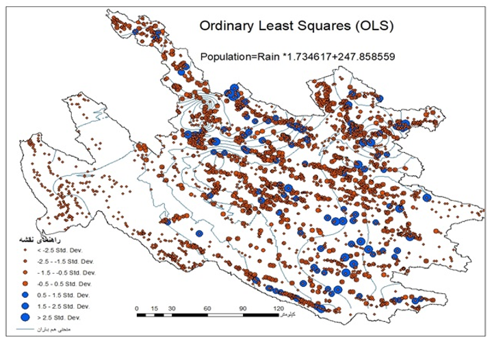
Figure 2) Spatial Analysis of Villages in the Mond Watershed Using the OLS Method
Table 1) Spatial Analysis of Villages in the Mond Watershed
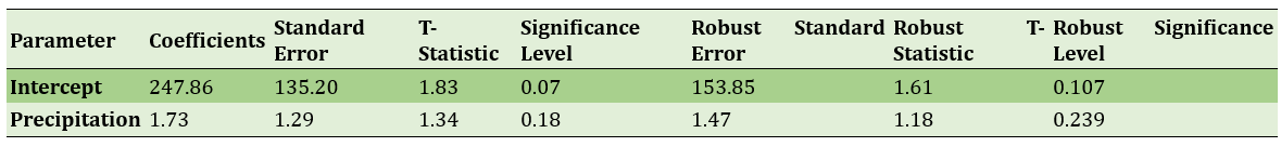
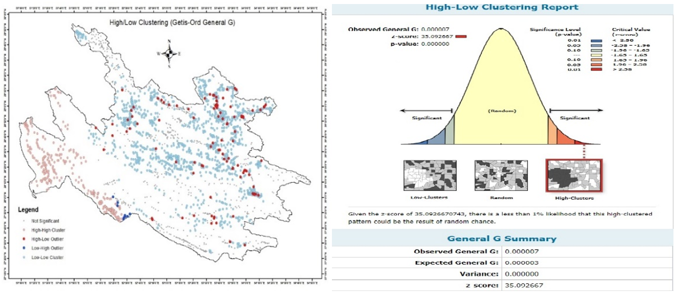
Figure 3) Spatial Clustering Analysis of Villages in the Mond Watershed Based on the G Statistic
The seasonal temperature analysis showed that the northern and northeastern areas offer better climatic conditions for growing crops such as wheat and grapes. In contrast, higher temperatures and reduced precipitation in the southern and eastern parts have made agriculture more challenging (Figure 4). The analysis of precipitation and land use changes indicated that by 2023, compared to 2015, rainfall had declined, and agricultural land coverage had decreased in the southern and eastern regions (Figures 5 and 6).
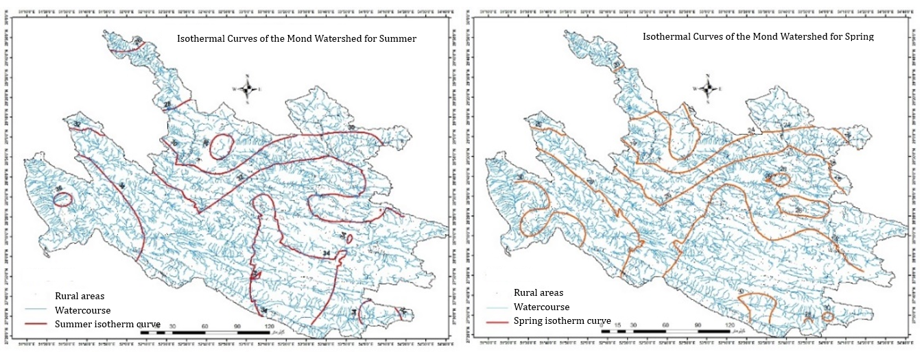
Figure 4) Isothermal Curves of the Mond Watershed for Summer (a) and Spring (b)
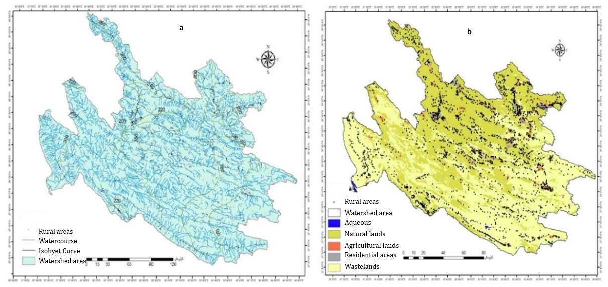
Figure 5) Land Use in 2015 Based on NDVI Index (b) and Isohyet Curve of the Same Year (a)
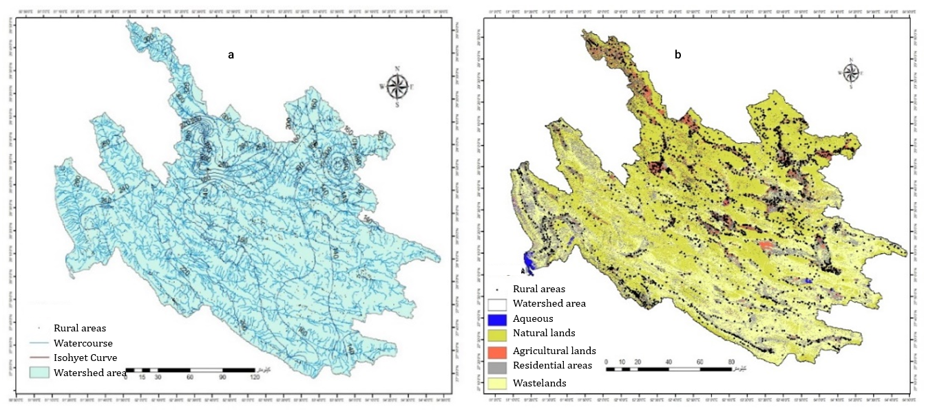
Figure 6) Land Use in 2023 Based on NDVI Index (b) and Isohyet Curve of the Same Year (a)
The changes in the cultivated area of the Mond watershed from 2010 to 2020 indicate significant variations in agricultural land based on the Normalized Difference Vegetation Index (NDVI) (Figure 7).
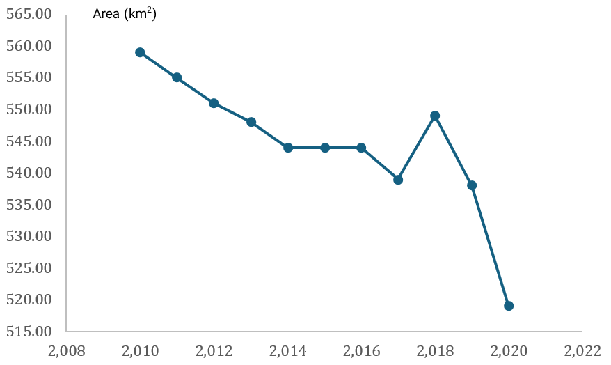
Figure 7) Changes in Cultivated Area in the Mond Watershed from 2010 to 2020
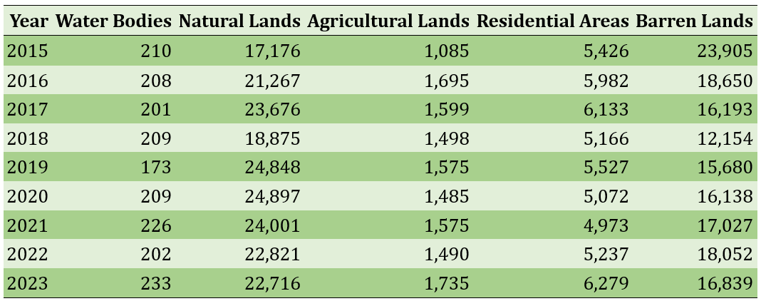
The depletion of groundwater between 2010 and 2023, particularly after 2015, negatively impacted agriculture (Figure 8). During this period, agricultural lands expanded by 37%, while barren lands decreased by 29% (Table 2). The findings highlight the necessity of effective water and agricultural resource management to ensure the sustainability of the region.
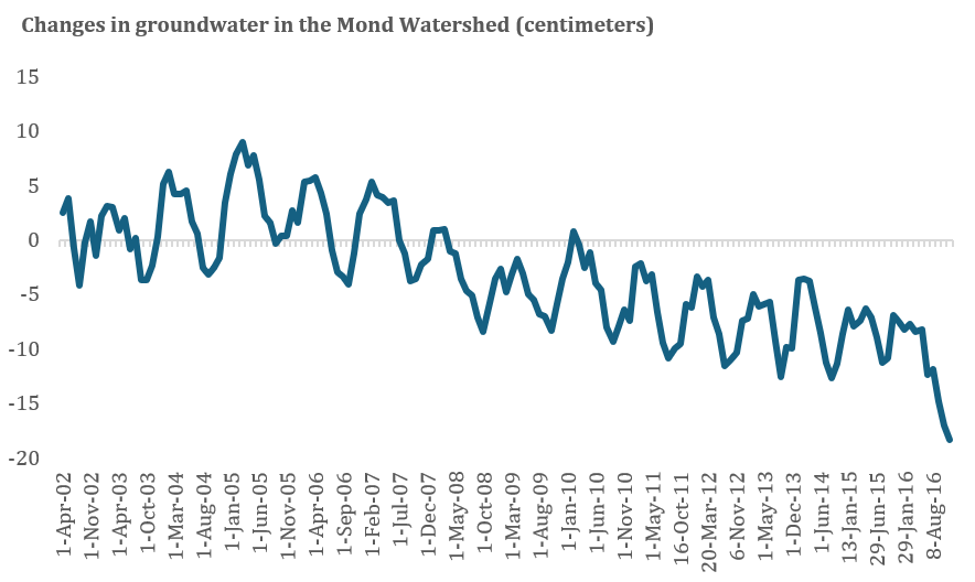
Figure 8) Groundwater Changes from 2010 to 2023 Based on GRACE Data in Earth Engine
Table 2) Area of Different Land Uses in the Mond Watershed
Main Comparisons to Similar Studies
The results align with prior research on groundwater depletion, land use changes, and their consequences for rural settlements. Gleeson et al. (2012) emphasize that over-extraction of groundwater is leading to a severe global crisis, a conclusion consistent with the findings of Famiglietti (2014), who identify groundwater depletion as a significant threat to agricultural and residential areas. Regarding land use changes, the findings support Asghari et al. (2019), who report that the expansion of residential and industrial areas has resulted in the degradation of agricultural lands. The results also align with Seto et al. (2012), who demonstrate the significant impact of urban expansion on water and agricultural resources. However, the study contrasts with Denaee Daryan & Riyahi (2021), who attributed agricultural land reduction to decreased village density, whereas this study identifies water resource depletion and climate changes as the primary causes. These differences may be due to geographical and climatic disparities between the study areas.
Suggestions
Sustainable water and land resource management requires the implementation of advanced irrigation systems, such as drip irrigation, and the development of rainwater harvesting technologies to reduce dependency on groundwater and enhance agricultural productivity. Policies restricting the conversion of agricultural land into residential areas should be enforced, alongside initiatives to support farmers in adopting drought-resistant crops and sustainable farming practices. Another crucial recommendation is the enforcement of strict regulations on groundwater extraction.
Conclusion
Land use changes, climate variations, and water resource depletion have directly influenced the sustainability of villages in the Mond watershed. According to the models, rising temperatures and decreasing precipitation in recent years increased stress on groundwater resources, leading to a reduction in agricultural land.
Acknowledgments: Nothing to declare.
Ethical Permission: Nothing to declare.
Conflict of Interest: There is no conflict of interest regarding the writing and publication of this article.
Author Contributions: Ejtemaei B (First Author), Introduction Writer / Methodologist / Main Researcher / Statistical Analyst / Discussion Writer (60%); Moghtaderi Gh (Second Author), Introduction Writer / Methodologist / Discussion Writer (40%)
Funding: Nothing to declare.
Watersheds, especially in arid and semi-arid regions, are significantly affected by land use changes, climate variations, and water resource management. Sustainable development in these areas requires a thorough understanding of environmental changes and the formulation of appropriate management strategies. The utilization of remote sensing technologies and spatial analysis has become crucial in assessing these changes.
Previous Studies
Numerous studies have explored land use changes, water resources, and their impacts on the sustainability of rural areas. Gleeson et al. (2012) have demonstrated through global water resource modeling that excessive groundwater extraction has led to a decline in water reserves worldwide, placing many arid regions at risk of water crises. Similarly, Famiglietti (2014) emphasize the severity of groundwater depletion using satellite data and hydrological models, highlighting its threat to agricultural communities. Regarding land use changes, Asghari et al. (2019) have found that the expansion of residential and industrial areas has led to the destruction of rangelands and agricultural lands in Iran. Denaee Daryan & Riyahi (2021) analyzed land use changes in Azarshahr and concluded that the reduction in village density directly affects the decline of agricultural lands. However, the present study suggests that in the Mond watershed, water resource depletion and climate changes are the primary drivers of these transformations rather than village density reduction. Seto et al. (2012) and Lambin & Meyfroidt (2011) examine the global impacts of land use changes, indicating that urban expansion and economic globalization exert significant pressure on natural resources. Additionally, Rockstrom et al. (2009) have concluded in a comprehensive study that unsustainable water consumption and climate changes are pushing certain regions toward critical thresholds. This study differs from previous research in several ways. While many studies have focused on either climate changes, water resources, or land use independently, this research examines all three factors simultaneously using satellite data from GRACE, MODIS, and Landsat for a more precise analysis.
Aim(s)
The primary objective of this study was to investigate the impacts of land use changes, climate variations, and water resource depletion on the sustainability of villages within the Mond watershed.
Research Type
This study is a descriptive-analytical and applied research incorporating remote sensing techniques, statistical analyses, and literature review to examine the subject matter.
Research Society, Place, and Time
The study was conducted on villages within the Mond watershed in southern Iran. Data were collected for the period from 2015 to 2023, utilizing satellite imagery and environmental datasets.
Sampling Method and Number
Data were gathered through satellite image analysis and Geographic Information System (GIS) techniques. GRACE data were employed to analyze water resource changes, while MODIS and Landsat data were used to assess land use transformations.
Used Devices & Materials
A combination of remote sensing data, statistical analysis, and GIS tools were utilized for this study. Satellite data included GRACE images for monitoring groundwater changes and MODIS and Landsat images for assessing land use changes between 2015 and 2023. These datasets were processed and analyzed using Google Earth Engine to accurately evaluate spatial and temporal environmental changes. Additionally, statistical analyses, such as Ordinary Least Squares (OLS) regression and spatial clustering analysis, were applied to examine the relationships between rainfall variations, rural population trends, and land use changes. NDVI was used to assess vegetation health and agricultural land trends, while GIS-based spatial analysis was conducted to investigate settlement patterns and water resource distribution.
Findings by Text
The sustainability of villages in the Mond watershed was influenced by three key factors of land use, climate, and water resources. These relationships were analyzed using remote sensing data within Google Earth Engine and GIS. The results indicated that the dominant climate in the region is semi-arid Mediterranean (29,170 km²), while the hot and dry climate (13,030 km²) also has a significant share, limiting agricultural activities (Figure 1).
Figure 1) Mond watershed climate
The OLS modeling demonstrated a positive relationship between precipitation and rural population; however, this relationship was not statistically significant (Table 1, Figure 2). Spatial clustering analysis revealed that villages are highly concentrated in specific areas, particularly in the northeastern part of the watershed (Figure 3).
Figure 2) Spatial Analysis of Villages in the Mond Watershed Using the OLS Method
Table 1) Spatial Analysis of Villages in the Mond Watershed
Figure 3) Spatial Clustering Analysis of Villages in the Mond Watershed Based on the G Statistic
The seasonal temperature analysis showed that the northern and northeastern areas offer better climatic conditions for growing crops such as wheat and grapes. In contrast, higher temperatures and reduced precipitation in the southern and eastern parts have made agriculture more challenging (Figure 4). The analysis of precipitation and land use changes indicated that by 2023, compared to 2015, rainfall had declined, and agricultural land coverage had decreased in the southern and eastern regions (Figures 5 and 6).
Figure 4) Isothermal Curves of the Mond Watershed for Summer (a) and Spring (b)
Figure 5) Land Use in 2015 Based on NDVI Index (b) and Isohyet Curve of the Same Year (a)
Figure 6) Land Use in 2023 Based on NDVI Index (b) and Isohyet Curve of the Same Year (a)
The changes in the cultivated area of the Mond watershed from 2010 to 2020 indicate significant variations in agricultural land based on the Normalized Difference Vegetation Index (NDVI) (Figure 7).
Figure 7) Changes in Cultivated Area in the Mond Watershed from 2010 to 2020
The depletion of groundwater between 2010 and 2023, particularly after 2015, negatively impacted agriculture (Figure 8). During this period, agricultural lands expanded by 37%, while barren lands decreased by 29% (Table 2). The findings highlight the necessity of effective water and agricultural resource management to ensure the sustainability of the region.
Figure 8) Groundwater Changes from 2010 to 2023 Based on GRACE Data in Earth Engine
Table 2) Area of Different Land Uses in the Mond Watershed
Main Comparisons to Similar Studies
The results align with prior research on groundwater depletion, land use changes, and their consequences for rural settlements. Gleeson et al. (2012) emphasize that over-extraction of groundwater is leading to a severe global crisis, a conclusion consistent with the findings of Famiglietti (2014), who identify groundwater depletion as a significant threat to agricultural and residential areas. Regarding land use changes, the findings support Asghari et al. (2019), who report that the expansion of residential and industrial areas has resulted in the degradation of agricultural lands. The results also align with Seto et al. (2012), who demonstrate the significant impact of urban expansion on water and agricultural resources. However, the study contrasts with Denaee Daryan & Riyahi (2021), who attributed agricultural land reduction to decreased village density, whereas this study identifies water resource depletion and climate changes as the primary causes. These differences may be due to geographical and climatic disparities between the study areas.
Suggestions
Sustainable water and land resource management requires the implementation of advanced irrigation systems, such as drip irrigation, and the development of rainwater harvesting technologies to reduce dependency on groundwater and enhance agricultural productivity. Policies restricting the conversion of agricultural land into residential areas should be enforced, alongside initiatives to support farmers in adopting drought-resistant crops and sustainable farming practices. Another crucial recommendation is the enforcement of strict regulations on groundwater extraction.
Conclusion
Land use changes, climate variations, and water resource depletion have directly influenced the sustainability of villages in the Mond watershed. According to the models, rising temperatures and decreasing precipitation in recent years increased stress on groundwater resources, leading to a reduction in agricultural land.
Acknowledgments: Nothing to declare.
Ethical Permission: Nothing to declare.
Conflict of Interest: There is no conflict of interest regarding the writing and publication of this article.
Author Contributions: Ejtemaei B (First Author), Introduction Writer / Methodologist / Main Researcher / Statistical Analyst / Discussion Writer (60%); Moghtaderi Gh (Second Author), Introduction Writer / Methodologist / Discussion Writer (40%)
Funding: Nothing to declare.
References
1. Ahmadzadeh H, Davarpanah M (2023). Spatial analysis of flood risk with a land use planning and management approach in Urmia City. Geography and Environmental Hazards. 12(2):63-80. [Persian] [Link]
2. Asghari Saraskanroud S, Mohammadnejad V, Emami H (2019). Analysis of land use changes using pixel-based and object-oriented methods and the effects of these changes on soil erosion (case study: Maragheh county). Quantitative Geomorphological Research. 8(1):160-178. [Persian] [Link]
3. Cui J, Zhu M, Liang Y, Qin G, Li J, Liu Y (2022). Land use/land cover change and their driving factors in the Yellow River Basin of Shandong Province based on google earth engine from 2000 to 2020. International Journal of Geo-Information. 11(3):163. [Link] [DOI:10.3390/ijgi11030163]
4. De Sousa JHS, Moreira AR, Nascimento AAD, Ribeiro GDN, Oliveira Neto JND, Prado Júnior LSD (2022). Assessment of land use and cover in the Sucuru Watershed using Google Earth Engine. Revista Verde De Agroecologia e Desenvolvimento Sustentável. 17(4):235-241. [Link] [DOI:10.18378/rvads.v17i4.9621]
5. Denaee Daryan M, Riyahi V (2021). Investigation of land use changes (case study: Azarshahr city). Geography and Human Relationships. 3(4):183-200. [Persian] [Link]
6. Famiglietti JS (2014). The global groundwater crisis. Nature Climate Change. 4(11):945-948. [Link] [DOI:10.1038/nclimate2425]
7. Farokhnia A, Morid S, Dalaver M (2018). Study of land use change in the Urmia lake water shed based on landsat-tm images and pixel-based and object-based classification techniques. Iranian Journal of Irrigation and Drainage. 12(4):823-839. [Persian] [Link]
8. Foley JA, DeFries R, Asner GP, Barford C, Bonan G, Carpenter SR, et al (2005). Global consequences of land use. Science. 309(5734):570-574. [Link] [DOI:10.1126/science.1111772]
9. Foley JA, Ramankutty N, Brauman KA, Cassidy ES, Gerber JS, Johnston M, et al (2011). Solutions for a cultivated planet. Nature. 478(7369):337-342. [Link] [DOI:10.1038/nature10452]
10. Gautam L, Rai R (2022). Land use and land cover change analysis using google earth engine in Manamati watershed of Kathmandu district, Nepal. The Third Pole Journal of Geography Education. 22:49-60. [Link] [DOI:10.3126/ttp.v22i01.52560]
11. Gleeson T, Wada Y, Bierkens MF, Van Beek LP (2012). Water balance of global aquifers revealed by groundwater footprint. Nature. 488(7410):197-200. [Link] [DOI:10.1038/nature11295]
12. Kazemi Garajeh M, Haji F, Tohidfar M, Sadeqi A, Ahmadi R, Kariminejad N (2024). Spatiotemporal monitoring of climate change impacts on water resources using an integrated approach of remote sensing and Google Earth Engine. Scientific Reports. 14(1):5469. [Link] [DOI:10.1038/s41598-024-56160-9]
13. Lal R (2015). Restoring soil quality to mitigate soil degradation. Sustainability. 7(5):5875-5895. [Link] [DOI:10.3390/su7055875]
14. Lambin EF, Meyfroidt P (2011). Global land use change, economic globalization, and the looming land scarcity. Proceedings of the National Academy of Sciences. 108(9):3465-3472. [Link] [DOI:10.1073/pnas.1100480108]
15. Osman MA, Abdel-Rahman EM, Onono JO, Olaka LA, Elhag MM, Adan M, et al (2023). Mapping, intensities and future prediction of land use/land cover dynamics using google earth engine and CA-artificial neural network model. PLoS One. 18(7):e0288694. [Link] [DOI:10.1371/journal.pone.0288694]
16. Pande CB (2022). Land use/land cover and change detection mapping in Rahuri watershed area (MS), India using the google earth engine and machine learning approach. Geocarto International. 37(26):13860-13880. [Link] [DOI:10.1080/10106049.2022.2086622]
17. Rockstrom J, Steffen W, Noone K, Persson Å, Chapin FS, Lambin EF, et al (2009). A safe operating space for humanity. Nature. 461(7263):472-475. [Link] [DOI:10.1038/461472a]
18. Seto KC, Güneralp B, Hutyra LR (2012). Global forecasts of urban expansion to 2030 and direct impacts on biodiversity and carbon pools. Proceedings of the National Academy of Sciences. 109(40):16083-16088. [Link] [DOI:10.1073/pnas.1211658109]
19. Seto KC, Reenberg A, Boone CG, Fragkias M, Haase D, Langanke T, et al (2012). Urban land teleconnections and sustainability. Proceedings of the National Academy of Sciences. 109(20):7687-7692. [Link] [DOI:10.1073/pnas.1117622109]
20. Siddique AB, Rayhan E, Sobhan F, Das N, Fazal MA, Riya SC, et al (2024). Spatio-temporal analysis of land use and land cover changes in a wetland ecosystem of Bangladesh using a machine-learning approach. Frontiers in Water. 6:1394863. [Link] [DOI:10.3389/frwa.2024.1394863]
21. Tesfaye W, Elias E, Warkineh B, Tekalign M, Abebe G (2024). Modeling of land use and land cover changes using google earth engine and machine learning approach: Implications for landscape management. Environmental Systems Research. 13(1):31. [Link] [DOI:10.1186/s40068-024-00366-3]
22. Thornton PK, Herrero M (2015). Adapting to climate change in the mixed crop and livestock farming systems in sub-Saharan Africa. Nature Climate Change. 5(9):830-836. [Link] [DOI:10.1038/nclimate2754]
23. Xiong H, Ma C, Li M, Tan J, Wang Y (2023). Landslide susceptibility prediction considering land use change and human activity: A case study under rapid urban expansion and afforestation in China. Science of the Total Environment. 866:161430. [Link] [DOI:10.1016/j.scitotenv.2023.161430]
24. Zhang M, Kafy AA, Xiao P, Han S, Zou S, Saha M, et al (2023). Impact of urban expansion on land surface temperature and carbon emissions using machine learning algorithms in Wuhan, China. Urban Climate. 47:101347. [Link] [DOI:10.1016/j.uclim.2022.101347]