
Bilingual
En/Fa
Geographical Research is Published in both Persian and English Full-text.
Volume 38, Issue 4 (2023)
GeoRes 2023, 38(4): 435-443 |
Back to browse issues page
Article Type:
Subject:


History
Received: 2023/06/11 | Accepted: 2023/10/8 | Published: 2023/10/18
Received: 2023/06/11 | Accepted: 2023/10/8 | Published: 2023/10/18
How to cite this article
Shahidi Rizi M, Irvani H, Jabal Ameli A, Piravi Vanak M. Space Syntax and Hermeneutics of Scale in Shahid Beheshti Street of Karaj. GeoRes 2023; 38 (4) :435-443
URL: http://georesearch.ir/article-1-1483-en.html
URL: http://georesearch.ir/article-1-1483-en.html
Download citation:
BibTeX | RIS | EndNote | Medlars | ProCite | Reference Manager | RefWorks
Send citation to:


Rights and permissions
BibTeX | RIS | EndNote | Medlars | ProCite | Reference Manager | RefWorks
Send citation to:

1- Department of Architecture and Urban Planning, Esfahan Branch, Islamic Azad University, Esfahan, Iran
2- Department of Architecture, Faculty of Architecture, Ardestan Branch, Islamic Azad University, Ardestan, Iran
3- Department of Artstudies, Isfahan University of Arts, Isfahan, Iran
2- Department of Architecture, Faculty of Architecture, Ardestan Branch, Islamic Azad University, Ardestan, Iran
3- Department of Artstudies, Isfahan University of Arts, Isfahan, Iran
Full-Text (HTML) (316 Views)
Introduction
Scale is one of the most important characteristics of urban spaces, playing a key role in creating a desirable connection between humans and space. The presence of this feature in urban spaces humanizes the environment and facilitates its perception. In the human-made environment, scale is essentially a perception of an object (in this case, the built environment) that relates to surrounding objects and how we perceive them. Therefore, scale is not a one-dimensional concept. Its multiple aspects and dimensions, along with its mental and perceptual nature, introduce the possibility of interpretation—this is where hermeneutics enters the discussion. Hence, the central issue of this article is the hermeneutic analysis of scale in urban spaces.
Hermeneutics of scale is a philosophical approach used in the examination and interpretation of cultural and social phenomena. In the context of urban spaces, hermeneutics of scale is applied as a method to gain a better understanding of the relationship between humans and the urban environment. The purpose of hermeneutical understanding of the environment is not to clarify the meaning of a work for its original audience or creator, but rather to express what this work (in this case, the urban space) means to visitors or residents. This matter is particularly prominent in architecture and urban planning due to the constant interaction with built environments.
Humans perceive and understand space according to their physical and mental perceptual abilities. Among the qualities discussed in urban design, the quality of human scale is one of the most influential factors shaping urban space. Human scale depends on size, texture, the compatibility of physical elements with human dimensions and proportions, and equally on human walking speed [Ahmadnejad et al., 2021]. In the human-made environment, including urban spaces, scale refers to the size and configuration of physical elements in harmony with human dimensions, proportions, and activities. In architecture, this concept emphasizes geometric proportions and the suitability of a building’s dimensions and components for human use [Neufert, 2019]. In addition to compatibility with human dimensions, enclosure is one of the key indicators of spatial scale in urban spaces. It not only reinforces harmony with human dimensions but also enhances the sense of security among citizens [Tibbalds, 2012]. Furthermore, spatial structure plays a crucial role in the scale of urban spaces. Spatial structure is more than just the relationship between elements; it is connected to human perception and citizens’ social behavior. Therefore, this article also explains the relationship between spatial structure and scale in urban spaces.
From a phenomenological perspective, place is a whole composed of real objects and things, with materials, textures, shapes, and colors. Together, these elements define the environmental character. For human intervention in the environment, one must understand the primary character of a place and create environments that align with it [Safian et al., 2012]. Thus, perceptual elements such as scale and space must be compatible in the manifestation of urban place. This compatibility can only be achieved by understanding the relationship between the two and their broader connection to the emergence of urban space.
Watsonville’s research defines and presents criteria such as continuity of street edges and facades, corridors, attention to natural heritage, housing distribution, and others in shaping urban space [Watsonville, 2012]. Ewing and Handy identified size, texture, compatibility of physical elements, human proportion, environmental components, and other factors as influential in the perception of scale [Ewing & Handy, 2009]. Shahabi Nejad et al. categorized a set of criteria into three groups: “proportion between spatial dimensions and human dimensions,” “spatial enclosure,” and “attention to the details of space and its activities” [Shahabi Nejad et al., 2015].
Beyond scale, the spatial structures of cities largely determine their functionality [Lindal & Hartig, 2013]. Inefficient spatial structures lead to increased distances between people, reduced facilities and amenities, and a decline in quality of life. Despite all the civilizational, human, and developmental achievements, cities today are filled with spatial, social, and environmental imbalances that threaten all human and physical activities [Alizadeh & Anbari, 2017]. This issue is particularly evident in urban streets.
Among various types of urban spaces, streets play a highly decisive role in enlivening the urban community. Their role extends from providing necessary access infrastructure to serving as a setting for social interactions, fostering cohesion, and invigorating the urban community [Alipour et al., 2018]. In general, streets are connective spaces that guide, divide, and reinforce the city’s structure [Nikpour & Yarahmadi, 2020]. However, Von Schonfeld and Bertolini noted that contemporary urban streets have created challenges and opportunities, leading to a sharper contrast between the major issues of “streets as traffic corridors” and “streets as public and social spaces” [Von Schonfeld & Bertolini, 2017]. Unfortunately, this issue can be observed in the structure of many Iranian cities’ streets, including those in Karaj. Among the streets of this city, Shahid Beheshti Street—due to its importance in the spatial, physical, social, and historical structure of Karaj—was selected as the study area [Fathi et al., 2023]. Therefore, the aim of this article is to examine the relationship between scale and spatial structure in urban streets as one of the most important types of urban spaces. Considering the diversity of definitions of the concept of scale, this study adopts a hermeneutic approach to interpret the concept.
Methodology
This study is applied in nature and was conducted in the first half of 2022 along Shahid Beheshti Street in Karaj (also known as Qazvin Street). The research analyzed the correlation between quantitative criteria derived from indirect observation, a researcher-made questionnaire, and spatial syntax analysis of the study area. According to studies by Hekmatnia et al. and Bonyadi et al., this axis has the strongest connection with Karaj’s urban network [Hekmatnia et al., 2022; Bonyadi et al., 2023]. In addition, Beheshti Street functions as the backbone of Karaj, linking its various parts. Due to the importance of this street in the city’s spatial, physical, social, and historical structure, it was selected for study. The street was examined based on spatial syntax and scale features in both urban and local contexts. The collected data were then integrated, and the objective and perceptual dimensions of scale were analyzed in relation to spatial syntax.
To obtain spatial data, the axial map of Karaj was produced by the researchers based on maps from Bavand Consulting Engineers in the Karaj detailed plan. The axial map was imported into UCL Depthmap 10 software, and the necessary analyses were extracted in two formats: axial maps and quantitative data tables. The main metrics included Integration, Choice, and Connectivity. In this study, the axial map is a simplified diagram of urban streets, where the “axial line” represents the longest line of sight and access.
The conceptual model of scale was developed based on data collected through the researcher-made questionnaire and validated using confirmatory factor analysis (CFA). The scale questionnaire consisted of 63 items grouped under 3 indicators and 7 criteria. The main indicators were Dimensions and Proportions, Enclosure, and Components and Activities. These indicators were adapted from the models of Shahabi Nejad et al. and Ewing & Handy, and were scored on a 5-point Likert scale [Ewing & Handy, 2009; Shahabi Nejad et al., 2015]. The face and content validity of the questionnaire were confirmed by 11 university lecturers and urban planning experts familiar with the study area. Content validity was assessed using the Content Validity Index (CVI). Items with a CVI above 0.75 were retained; others were removed (Table 1).
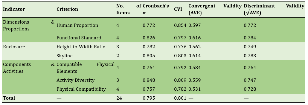
Table 1. Cronbach’s Alpha, convergent and discriminant validity from factor analysis, and scale indicators in Beheshti Street, Karaj
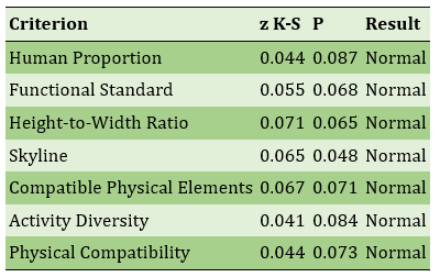
The normality of the distribution of criteria was examined to ensure the applicability of parametric tests, using the Kolmogorov–Smirnov test (Table 2). The z-statistic for all criteria was not significant at the 0.05 level. Based on these findings, the distribution of criteria was considered normal, making parametric tests suitable for the research questions.
Table 2. Kolmogorov–Smirnov test results for normality of scale criteria distribution
After entering the variance–covariance data into LISREL 8.80 software, the effects of the indicators “Dimensions and Proportions,” “Enclosure,” and “Components and Activities” on their respective criteria were extracted. The results of CFA and the factor loadings showed that all factor loadings exceeded the minimum acceptable threshold of 0.50, indicating the adequacy of the measurement model. The explained variance demonstrated the predictive ability of each criterion by its respective items. Composite reliability, average variance extracted (AVE), and Cronbach’s alpha (values above 0.50 considered acceptable) were all within satisfactory ranges.
The statistical population included all individuals present along this street. To maintain consistency in the study and improve accuracy, the street was divided into four sequences (sections). The sample size was calculated using Cochran’s formula with a 95% confidence level and a 5% margin of error, resulting in 384 respondents (in each sequence). Figure 1 shows the map of the studied sequences of Beheshti Street along with the surrounding street network. The five images at the top illustrate the different sequences of Beheshti Street.
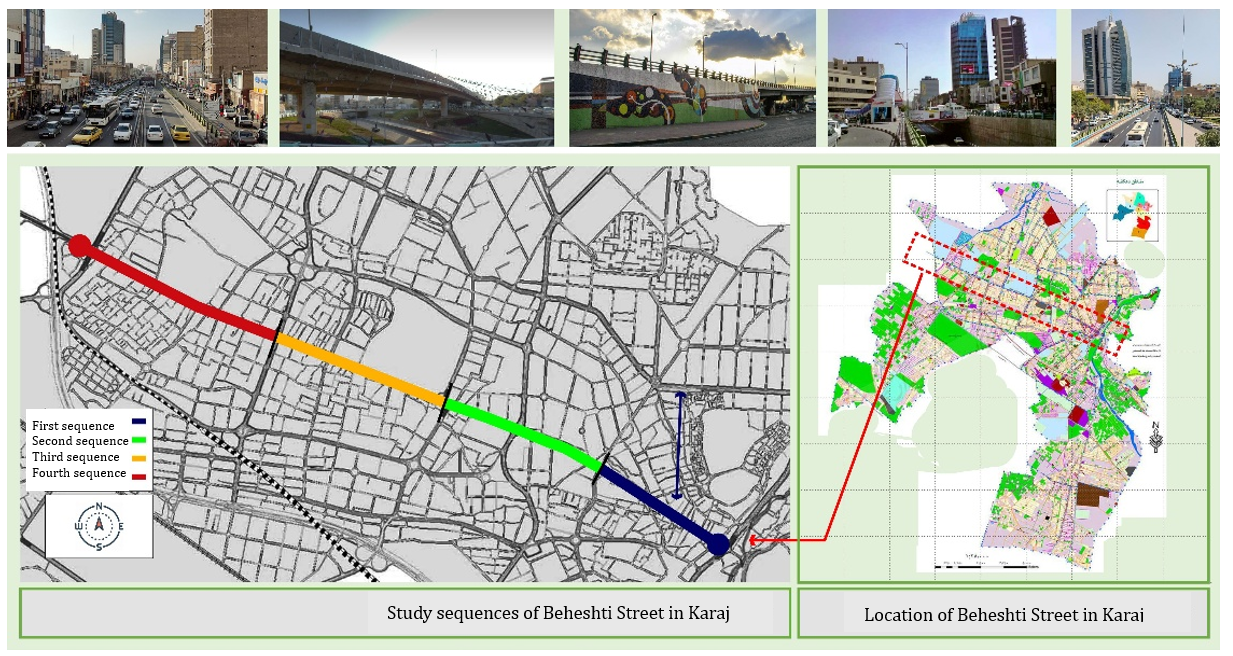
Figure 1. Approximate map of the study area (Beheshti Street) and research sequences
Confirmatory factor analysis was performed using the Partial Least Squares (PLS) method. The ratio of criteria to sample size adequacy was assessed with Bartlett’s test at a confidence level above 95%, and a KMO value below 0.60. The results confirmed satisfactory reliability and convergent validity (Table 1).
Findings
After extracting the data related to the spatial structure, the relationship between the research criteria was analyzed using the factor analysis method. In the research model, there were two main types of criteria: external criteria, which were considered independent, and internal criteria. The relationship of the three main indicators with the criteria was such that the first category pertained, in order, to the impact level of the dimensional and proportionality criteria, including human scale proportion and functional standards (Table 3). The factor loading of each item was also determined in relation to its respective criterion. Based on the beta value (Estimate), the critical ratio (C.R), and the significance level (P), it was determined that there was a significant relationship between these indicators and the scale factor. Within this criterion, sidewalk width had the highest coefficient, while green space area had the lowest.
Table 3) Factor loadings and estimated shared variance of questions on Beheshti Street scale
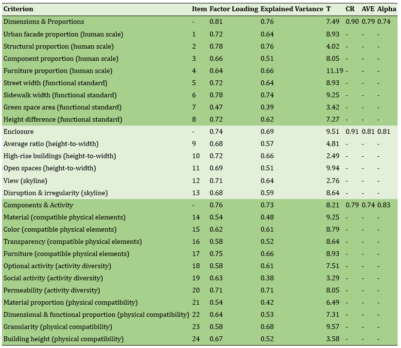
After sidewalk width, furniture had the greatest influence. The range of factor loadings among the eight items of the "dimensions & proportions" index varied between 0.47 and 0.78, indicating the relatively close influence of different factors in "dimensions & proportions." In the "enclosure" factors, the presence of high-rise buildings with a factor loading of 0.72 had the greatest influence. In the "components & activity" category, after furniture, permeability had the highest loading at 0.71. The significance of the relationship between these criteria and the scale was confirmed.
Using the space syntax method, the arrangement of all existing urban spaces in sequence (spatial configuration) was analyzed. The analysis began with the preparation of the axial map, formed from a minimum set of straight lines passing through convex spaces. By drawing the axial map of Karaj, various "space syntax" parameters were extracted. In these maps, each line (pathway) was color-coded from warm tones (brown) to cool tones (dark blue), with warm colors indicating higher values (maximum 10) and cool colors indicating lower values (minimum 0). As evident, the depth was greater in the northern areas, especially older neighborhoods (Figure 2). In Karaj’s urban structure, the highest choice value belonged to Beheshti Street (Qazvin).

Figure 2) a) Integration of the fabric around Beheshti Street; b) Depth of the fabric around Beheshti Street; c) Choice in the fabric around Beheshti Street; d) Connectivity of the fabric around Beheshti Street.
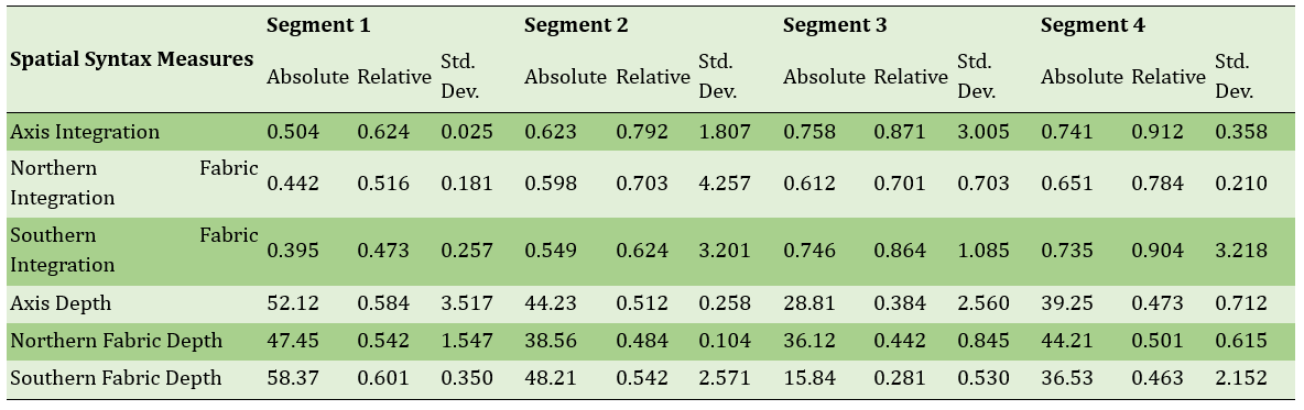
For more precise analysis of the spatial structure of the streets around Beheshti Street, another map was prepared showing the distribution pattern of integration and depth for each segment of Beheshti Street (Figure 3). These maps also measured the integration and depth of the surrounding street network in relation to Beheshti Street. Furthermore, quantitative values of spatial configuration criteria for each segment were presented (Table 4). The absolute value represents the mean output from the software for the urban network, while the relative value ranges from 0 to 1 and is calculated in relation to the streets in the study area.
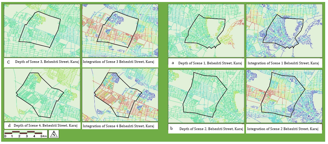
Figure 3) Integration and depth of the four segments of Beheshti Street.
Table 4) Spatial syntax criteria (integration and depth) of Beheshti Street by study segments
To assess the relationship between spatial analysis results and the perceived scale, streets identified by respondents as having undesirable scale were marked on the map. The size of these marks corresponded to the frequency of responses. These marks were then compared with the depth and integration maps. The comparison showed no significant correlation between integration and depth; in other words, streets with similar depth or integration were not always perceived by respondents as having scale errors. Therefore, data matching was performed across each segment, examining the relationship between the three scale indices (dimensions & proportions, enclosure, components & activity) with the integration and depth of Beheshti Street and its northern and southern networks. The correlation coefficients are presented in Table 5.
Table 5) Pearson correlation coefficients between scale criteria and space syntax parameters of Beheshti Street, Karaj.
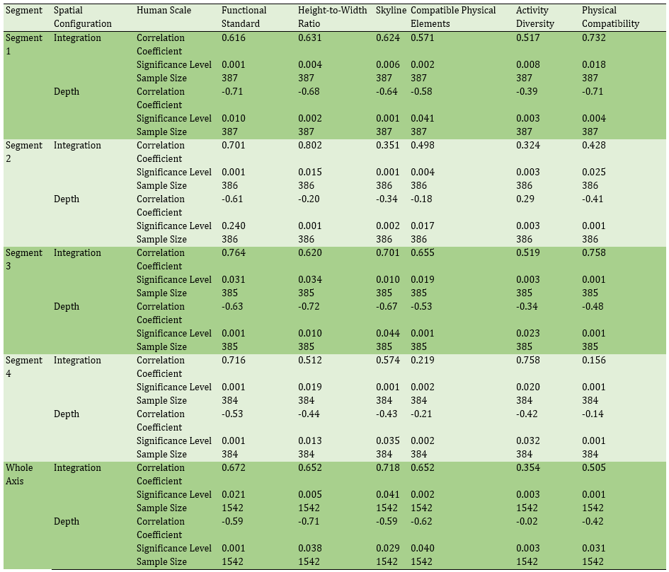
After testing the theoretical research model and confirming the effect of the identified factors on scale perception errors in Beheshti Street, Karaj, the issue of space syntax analysis was examined for predicting the potential impact of urban projects on improving street scale. The extracted correlation coefficients indicated a strong direct relationship between integration and dimensions & proportions, and a strong inverse relationship between depth and dimensions & proportions. These relationships were not observed between the components & activity factors, meaning that increasing integration in Beheshti Street does not necessarily increase components and activities. Among the criteria influencing scale, the environmental liveliness indicators of the street showed a significant relationship with the spatial configuration of the street network. In fact, despite the stronger impact of the dimensions and enclosure criteria on scale perception in Beheshti Street, components did not play a significant role in this perception (Table 5).
Discussion
The aim of this article was to examine the relationship between scale in various perceptual and objective dimensions and spatial structure on Beheshti Street in Karaj. The findings showed that "scale" is not a simple concept. Rather, this concept, besides being divisible into different components, is perceived differently by different individuals, making it hermeneutic and interpretable. Considering this common characteristic of scale and space concepts in urban environments, a model was developed based on previous studies to assess the relationship between these two, and quantitative methods were employed to measure this connection.
After validating the research model and confirming its compatibility with the models by Shahabi Nejad et al. and Ewing & Handy [Ewing & Handy, 2009; Shahabi Nejad et al., 2015], the second application of space syntax analysis was on axial components. The current study’s findings confirmed a significant relationship between the objective dimension of scale and space syntax on Beheshti Street. This result shows relative consistency with Van Der Hoeven and Van Nes, although their study was conducted in an urban metro network. Their results also indicated a meaningful relationship between dimensions (such as height-to-width ratios) and space syntax in urban environments [Van Der Hoeven & Van Nes, 2014].
The present research identified a weak correlation between space syntax metrics and pedestrians' walking inclination, while this relationship was much stronger for physical form indicators. This differs from the findings of Lamíquiz and López, who reported a connection between integration and pedestrian preference. However, the physical form measurement sections of both studies align closely. This discrepancy highlights the need to revisit this subject at the neighborhood level within urban street networks [Lamíquiz & López-Domínguez, 2015].
As noted earlier in this paper, no independent study exactly matching this research approach was available, but parts of it correspond with findings in other studies. For instance, Esposito et al. considered both quantitative and qualitative approaches in analyzing urban streets in Italy to understand their relationships with spatial dimensions such as building heights, recognizing their validity in urban planning [Esposito et al., 2020]. This aligns with the quantitative approach employed in the present study.
However, using space syntax methods in this study, given the two-dimensional nature of the technique, may impose limitations, especially when analyzing three-dimensional aspects like building heights in scale evaluation. This issue was also recognized in the study by Xing and Guo, who used adjusted geographic data and examined the relationship between spatial syntax indices and height proportions in urban spaces [Xing & Guo, 2022].
The importance of adjacent building heights on Beheshti Street was identified in several scale-related criteria, influencing individuals' perception of scale and desirable enclosure. This finding is consistent with studies by Wang et al. and Shen et al. [Wang et al., 2019; Shen et al., 2018]. However, no independent study has found a relationship between this and space syntax indicators. The closest research is by Xing and Guo, which identified wide streets and tall buildings in China as factors reducing environmental perception by citizens [Xing & Guo, 2022]. This is consistent with findings in sequences 3 and 4 of Beheshti Street, where lower enclosure and higher visual clutter due to isolated tall buildings were observed.
This study’s findings also indicate the minor impact of green spaces on scale perception on Beheshti Street and no relationship between integration of the main axis and surroundings with green space indicators. This lack of correlation has not been reported in other studies. Wang et al. identified plants and green spaces as the most important visual factors with an average of 1.01 in their analysis of streets in Binjiang, Hangzhou, East China [Wang et al., 2022]. Jabbari et al. also identified green spaces as highly influential in prioritizing urban streets in Porto, Portugal [Jabbari et al., 2018]. Similar findings were reported by Ye et al. in Singapore and Dharmasthala et al. in Bendigo, Australia [Ye et al., 2019; Dharmasthala et al., 2021]. In Iran, Bahrini et al. confirmed the relationship between green spaces and parks and citizens’ perception across various dimensions [Bahrini et al., 2017].
Therefore, it seems necessary to approach findings related to green spaces on Beheshti Street with more caution. Moreover, among the two existing analytical approaches—qualitative and quantitative—this research solely relied on quantitative data. It appears essential to conduct complementary studies using qualitative or mixed methods to clarify the various dimensions of the scale concept and urban spatial structure.
Conclusion
There is a direct relationship between the indicators of "dimensions and proportions," "enclosure," "components and activities," and the scale of the urban street. Changes in any of these indicators can alter the scale in both its objective and perceptual dimensions. Furthermore, the scale in both objective and perceptual dimensions has a significant relationship with the spatial structure of Shahid Beheshti Street in Karaj. This relationship is direct with the "integration" metric and inverse with the "depth" metric.
Acknowledgments: The authors sincerely thank all those who assisted in the fieldwork of this research.
Ethical Approval: The authors have adhered to ethical principles and scientific standards such as integrity, confidentiality, honesty, and so forth.
Conflict of Interest: This article is derived from the doctoral dissertation of Morteza Shahidi entitled "Hermeneutics of Scale in Built Environments," conducted under the supervision of the second and third authors and advised by the fourth author at Islamic Azad University, Isfahan Branch.
Authors’ Contributions: Shahidi Rizi M (First author): Main researcher /Discussion writer (50%); Irvani H (Second author): Methodologist /Assistant researcher (20%); Jabal Ameli A (Third author): Assistant researcher /Statistical analyst (20%); Piravi Vanak M (Fourth author): Assistant researcher/introduction writer (10%)
Funding: No financial support was reported by the authors.
Scale is one of the most important characteristics of urban spaces, playing a key role in creating a desirable connection between humans and space. The presence of this feature in urban spaces humanizes the environment and facilitates its perception. In the human-made environment, scale is essentially a perception of an object (in this case, the built environment) that relates to surrounding objects and how we perceive them. Therefore, scale is not a one-dimensional concept. Its multiple aspects and dimensions, along with its mental and perceptual nature, introduce the possibility of interpretation—this is where hermeneutics enters the discussion. Hence, the central issue of this article is the hermeneutic analysis of scale in urban spaces.
Hermeneutics of scale is a philosophical approach used in the examination and interpretation of cultural and social phenomena. In the context of urban spaces, hermeneutics of scale is applied as a method to gain a better understanding of the relationship between humans and the urban environment. The purpose of hermeneutical understanding of the environment is not to clarify the meaning of a work for its original audience or creator, but rather to express what this work (in this case, the urban space) means to visitors or residents. This matter is particularly prominent in architecture and urban planning due to the constant interaction with built environments.
Humans perceive and understand space according to their physical and mental perceptual abilities. Among the qualities discussed in urban design, the quality of human scale is one of the most influential factors shaping urban space. Human scale depends on size, texture, the compatibility of physical elements with human dimensions and proportions, and equally on human walking speed [Ahmadnejad et al., 2021]. In the human-made environment, including urban spaces, scale refers to the size and configuration of physical elements in harmony with human dimensions, proportions, and activities. In architecture, this concept emphasizes geometric proportions and the suitability of a building’s dimensions and components for human use [Neufert, 2019]. In addition to compatibility with human dimensions, enclosure is one of the key indicators of spatial scale in urban spaces. It not only reinforces harmony with human dimensions but also enhances the sense of security among citizens [Tibbalds, 2012]. Furthermore, spatial structure plays a crucial role in the scale of urban spaces. Spatial structure is more than just the relationship between elements; it is connected to human perception and citizens’ social behavior. Therefore, this article also explains the relationship between spatial structure and scale in urban spaces.
From a phenomenological perspective, place is a whole composed of real objects and things, with materials, textures, shapes, and colors. Together, these elements define the environmental character. For human intervention in the environment, one must understand the primary character of a place and create environments that align with it [Safian et al., 2012]. Thus, perceptual elements such as scale and space must be compatible in the manifestation of urban place. This compatibility can only be achieved by understanding the relationship between the two and their broader connection to the emergence of urban space.
Watsonville’s research defines and presents criteria such as continuity of street edges and facades, corridors, attention to natural heritage, housing distribution, and others in shaping urban space [Watsonville, 2012]. Ewing and Handy identified size, texture, compatibility of physical elements, human proportion, environmental components, and other factors as influential in the perception of scale [Ewing & Handy, 2009]. Shahabi Nejad et al. categorized a set of criteria into three groups: “proportion between spatial dimensions and human dimensions,” “spatial enclosure,” and “attention to the details of space and its activities” [Shahabi Nejad et al., 2015].
Beyond scale, the spatial structures of cities largely determine their functionality [Lindal & Hartig, 2013]. Inefficient spatial structures lead to increased distances between people, reduced facilities and amenities, and a decline in quality of life. Despite all the civilizational, human, and developmental achievements, cities today are filled with spatial, social, and environmental imbalances that threaten all human and physical activities [Alizadeh & Anbari, 2017]. This issue is particularly evident in urban streets.
Among various types of urban spaces, streets play a highly decisive role in enlivening the urban community. Their role extends from providing necessary access infrastructure to serving as a setting for social interactions, fostering cohesion, and invigorating the urban community [Alipour et al., 2018]. In general, streets are connective spaces that guide, divide, and reinforce the city’s structure [Nikpour & Yarahmadi, 2020]. However, Von Schonfeld and Bertolini noted that contemporary urban streets have created challenges and opportunities, leading to a sharper contrast between the major issues of “streets as traffic corridors” and “streets as public and social spaces” [Von Schonfeld & Bertolini, 2017]. Unfortunately, this issue can be observed in the structure of many Iranian cities’ streets, including those in Karaj. Among the streets of this city, Shahid Beheshti Street—due to its importance in the spatial, physical, social, and historical structure of Karaj—was selected as the study area [Fathi et al., 2023]. Therefore, the aim of this article is to examine the relationship between scale and spatial structure in urban streets as one of the most important types of urban spaces. Considering the diversity of definitions of the concept of scale, this study adopts a hermeneutic approach to interpret the concept.
Methodology
This study is applied in nature and was conducted in the first half of 2022 along Shahid Beheshti Street in Karaj (also known as Qazvin Street). The research analyzed the correlation between quantitative criteria derived from indirect observation, a researcher-made questionnaire, and spatial syntax analysis of the study area. According to studies by Hekmatnia et al. and Bonyadi et al., this axis has the strongest connection with Karaj’s urban network [Hekmatnia et al., 2022; Bonyadi et al., 2023]. In addition, Beheshti Street functions as the backbone of Karaj, linking its various parts. Due to the importance of this street in the city’s spatial, physical, social, and historical structure, it was selected for study. The street was examined based on spatial syntax and scale features in both urban and local contexts. The collected data were then integrated, and the objective and perceptual dimensions of scale were analyzed in relation to spatial syntax.
To obtain spatial data, the axial map of Karaj was produced by the researchers based on maps from Bavand Consulting Engineers in the Karaj detailed plan. The axial map was imported into UCL Depthmap 10 software, and the necessary analyses were extracted in two formats: axial maps and quantitative data tables. The main metrics included Integration, Choice, and Connectivity. In this study, the axial map is a simplified diagram of urban streets, where the “axial line” represents the longest line of sight and access.
The conceptual model of scale was developed based on data collected through the researcher-made questionnaire and validated using confirmatory factor analysis (CFA). The scale questionnaire consisted of 63 items grouped under 3 indicators and 7 criteria. The main indicators were Dimensions and Proportions, Enclosure, and Components and Activities. These indicators were adapted from the models of Shahabi Nejad et al. and Ewing & Handy, and were scored on a 5-point Likert scale [Ewing & Handy, 2009; Shahabi Nejad et al., 2015]. The face and content validity of the questionnaire were confirmed by 11 university lecturers and urban planning experts familiar with the study area. Content validity was assessed using the Content Validity Index (CVI). Items with a CVI above 0.75 were retained; others were removed (Table 1).
Table 1. Cronbach’s Alpha, convergent and discriminant validity from factor analysis, and scale indicators in Beheshti Street, Karaj
The normality of the distribution of criteria was examined to ensure the applicability of parametric tests, using the Kolmogorov–Smirnov test (Table 2). The z-statistic for all criteria was not significant at the 0.05 level. Based on these findings, the distribution of criteria was considered normal, making parametric tests suitable for the research questions.
Table 2. Kolmogorov–Smirnov test results for normality of scale criteria distribution
After entering the variance–covariance data into LISREL 8.80 software, the effects of the indicators “Dimensions and Proportions,” “Enclosure,” and “Components and Activities” on their respective criteria were extracted. The results of CFA and the factor loadings showed that all factor loadings exceeded the minimum acceptable threshold of 0.50, indicating the adequacy of the measurement model. The explained variance demonstrated the predictive ability of each criterion by its respective items. Composite reliability, average variance extracted (AVE), and Cronbach’s alpha (values above 0.50 considered acceptable) were all within satisfactory ranges.
The statistical population included all individuals present along this street. To maintain consistency in the study and improve accuracy, the street was divided into four sequences (sections). The sample size was calculated using Cochran’s formula with a 95% confidence level and a 5% margin of error, resulting in 384 respondents (in each sequence). Figure 1 shows the map of the studied sequences of Beheshti Street along with the surrounding street network. The five images at the top illustrate the different sequences of Beheshti Street.
Figure 1. Approximate map of the study area (Beheshti Street) and research sequences
Confirmatory factor analysis was performed using the Partial Least Squares (PLS) method. The ratio of criteria to sample size adequacy was assessed with Bartlett’s test at a confidence level above 95%, and a KMO value below 0.60. The results confirmed satisfactory reliability and convergent validity (Table 1).
Findings
After extracting the data related to the spatial structure, the relationship between the research criteria was analyzed using the factor analysis method. In the research model, there were two main types of criteria: external criteria, which were considered independent, and internal criteria. The relationship of the three main indicators with the criteria was such that the first category pertained, in order, to the impact level of the dimensional and proportionality criteria, including human scale proportion and functional standards (Table 3). The factor loading of each item was also determined in relation to its respective criterion. Based on the beta value (Estimate), the critical ratio (C.R), and the significance level (P), it was determined that there was a significant relationship between these indicators and the scale factor. Within this criterion, sidewalk width had the highest coefficient, while green space area had the lowest.
Table 3) Factor loadings and estimated shared variance of questions on Beheshti Street scale
After sidewalk width, furniture had the greatest influence. The range of factor loadings among the eight items of the "dimensions & proportions" index varied between 0.47 and 0.78, indicating the relatively close influence of different factors in "dimensions & proportions." In the "enclosure" factors, the presence of high-rise buildings with a factor loading of 0.72 had the greatest influence. In the "components & activity" category, after furniture, permeability had the highest loading at 0.71. The significance of the relationship between these criteria and the scale was confirmed.
Using the space syntax method, the arrangement of all existing urban spaces in sequence (spatial configuration) was analyzed. The analysis began with the preparation of the axial map, formed from a minimum set of straight lines passing through convex spaces. By drawing the axial map of Karaj, various "space syntax" parameters were extracted. In these maps, each line (pathway) was color-coded from warm tones (brown) to cool tones (dark blue), with warm colors indicating higher values (maximum 10) and cool colors indicating lower values (minimum 0). As evident, the depth was greater in the northern areas, especially older neighborhoods (Figure 2). In Karaj’s urban structure, the highest choice value belonged to Beheshti Street (Qazvin).
Figure 2) a) Integration of the fabric around Beheshti Street; b) Depth of the fabric around Beheshti Street; c) Choice in the fabric around Beheshti Street; d) Connectivity of the fabric around Beheshti Street.
For more precise analysis of the spatial structure of the streets around Beheshti Street, another map was prepared showing the distribution pattern of integration and depth for each segment of Beheshti Street (Figure 3). These maps also measured the integration and depth of the surrounding street network in relation to Beheshti Street. Furthermore, quantitative values of spatial configuration criteria for each segment were presented (Table 4). The absolute value represents the mean output from the software for the urban network, while the relative value ranges from 0 to 1 and is calculated in relation to the streets in the study area.
Figure 3) Integration and depth of the four segments of Beheshti Street.
Table 4) Spatial syntax criteria (integration and depth) of Beheshti Street by study segments
To assess the relationship between spatial analysis results and the perceived scale, streets identified by respondents as having undesirable scale were marked on the map. The size of these marks corresponded to the frequency of responses. These marks were then compared with the depth and integration maps. The comparison showed no significant correlation between integration and depth; in other words, streets with similar depth or integration were not always perceived by respondents as having scale errors. Therefore, data matching was performed across each segment, examining the relationship between the three scale indices (dimensions & proportions, enclosure, components & activity) with the integration and depth of Beheshti Street and its northern and southern networks. The correlation coefficients are presented in Table 5.
Table 5) Pearson correlation coefficients between scale criteria and space syntax parameters of Beheshti Street, Karaj.
After testing the theoretical research model and confirming the effect of the identified factors on scale perception errors in Beheshti Street, Karaj, the issue of space syntax analysis was examined for predicting the potential impact of urban projects on improving street scale. The extracted correlation coefficients indicated a strong direct relationship between integration and dimensions & proportions, and a strong inverse relationship between depth and dimensions & proportions. These relationships were not observed between the components & activity factors, meaning that increasing integration in Beheshti Street does not necessarily increase components and activities. Among the criteria influencing scale, the environmental liveliness indicators of the street showed a significant relationship with the spatial configuration of the street network. In fact, despite the stronger impact of the dimensions and enclosure criteria on scale perception in Beheshti Street, components did not play a significant role in this perception (Table 5).
Discussion
The aim of this article was to examine the relationship between scale in various perceptual and objective dimensions and spatial structure on Beheshti Street in Karaj. The findings showed that "scale" is not a simple concept. Rather, this concept, besides being divisible into different components, is perceived differently by different individuals, making it hermeneutic and interpretable. Considering this common characteristic of scale and space concepts in urban environments, a model was developed based on previous studies to assess the relationship between these two, and quantitative methods were employed to measure this connection.
After validating the research model and confirming its compatibility with the models by Shahabi Nejad et al. and Ewing & Handy [Ewing & Handy, 2009; Shahabi Nejad et al., 2015], the second application of space syntax analysis was on axial components. The current study’s findings confirmed a significant relationship between the objective dimension of scale and space syntax on Beheshti Street. This result shows relative consistency with Van Der Hoeven and Van Nes, although their study was conducted in an urban metro network. Their results also indicated a meaningful relationship between dimensions (such as height-to-width ratios) and space syntax in urban environments [Van Der Hoeven & Van Nes, 2014].
The present research identified a weak correlation between space syntax metrics and pedestrians' walking inclination, while this relationship was much stronger for physical form indicators. This differs from the findings of Lamíquiz and López, who reported a connection between integration and pedestrian preference. However, the physical form measurement sections of both studies align closely. This discrepancy highlights the need to revisit this subject at the neighborhood level within urban street networks [Lamíquiz & López-Domínguez, 2015].
As noted earlier in this paper, no independent study exactly matching this research approach was available, but parts of it correspond with findings in other studies. For instance, Esposito et al. considered both quantitative and qualitative approaches in analyzing urban streets in Italy to understand their relationships with spatial dimensions such as building heights, recognizing their validity in urban planning [Esposito et al., 2020]. This aligns with the quantitative approach employed in the present study.
However, using space syntax methods in this study, given the two-dimensional nature of the technique, may impose limitations, especially when analyzing three-dimensional aspects like building heights in scale evaluation. This issue was also recognized in the study by Xing and Guo, who used adjusted geographic data and examined the relationship between spatial syntax indices and height proportions in urban spaces [Xing & Guo, 2022].
The importance of adjacent building heights on Beheshti Street was identified in several scale-related criteria, influencing individuals' perception of scale and desirable enclosure. This finding is consistent with studies by Wang et al. and Shen et al. [Wang et al., 2019; Shen et al., 2018]. However, no independent study has found a relationship between this and space syntax indicators. The closest research is by Xing and Guo, which identified wide streets and tall buildings in China as factors reducing environmental perception by citizens [Xing & Guo, 2022]. This is consistent with findings in sequences 3 and 4 of Beheshti Street, where lower enclosure and higher visual clutter due to isolated tall buildings were observed.
This study’s findings also indicate the minor impact of green spaces on scale perception on Beheshti Street and no relationship between integration of the main axis and surroundings with green space indicators. This lack of correlation has not been reported in other studies. Wang et al. identified plants and green spaces as the most important visual factors with an average of 1.01 in their analysis of streets in Binjiang, Hangzhou, East China [Wang et al., 2022]. Jabbari et al. also identified green spaces as highly influential in prioritizing urban streets in Porto, Portugal [Jabbari et al., 2018]. Similar findings were reported by Ye et al. in Singapore and Dharmasthala et al. in Bendigo, Australia [Ye et al., 2019; Dharmasthala et al., 2021]. In Iran, Bahrini et al. confirmed the relationship between green spaces and parks and citizens’ perception across various dimensions [Bahrini et al., 2017].
Therefore, it seems necessary to approach findings related to green spaces on Beheshti Street with more caution. Moreover, among the two existing analytical approaches—qualitative and quantitative—this research solely relied on quantitative data. It appears essential to conduct complementary studies using qualitative or mixed methods to clarify the various dimensions of the scale concept and urban spatial structure.
Conclusion
There is a direct relationship between the indicators of "dimensions and proportions," "enclosure," "components and activities," and the scale of the urban street. Changes in any of these indicators can alter the scale in both its objective and perceptual dimensions. Furthermore, the scale in both objective and perceptual dimensions has a significant relationship with the spatial structure of Shahid Beheshti Street in Karaj. This relationship is direct with the "integration" metric and inverse with the "depth" metric.
Acknowledgments: The authors sincerely thank all those who assisted in the fieldwork of this research.
Ethical Approval: The authors have adhered to ethical principles and scientific standards such as integrity, confidentiality, honesty, and so forth.
Conflict of Interest: This article is derived from the doctoral dissertation of Morteza Shahidi entitled "Hermeneutics of Scale in Built Environments," conducted under the supervision of the second and third authors and advised by the fourth author at Islamic Azad University, Isfahan Branch.
Authors’ Contributions: Shahidi Rizi M (First author): Main researcher /Discussion writer (50%); Irvani H (Second author): Methodologist /Assistant researcher (20%); Jabal Ameli A (Third author): Assistant researcher /Statistical analyst (20%); Piravi Vanak M (Fourth author): Assistant researcher/introduction writer (10%)
Funding: No financial support was reported by the authors.
Keywords:
References
1. Ahmadnejad F, Adeebkia V, Hassanzadeh M, Rouhani H (2021). Investigation of the human scale in the city's events under study: Urmia city. Urban Design Studies and Urban Research. 4(3):13-26. [Persian] [Link]
2. Alipour Esfahani M, Zamani B, Shahivandi A (2018). Compiling components affecting the quality of social vitality in streets (case study: Historic street of Sepah, Isfahan). Maremat & Me'mari-e Iran. 8(15):119-136. [Persian] [Link]
3. Alizadeh K, Anbari H (2017). The role of urban spaces defenseless in occurrence of crime with an emphasis on Parks District 9 Mashhad. Research and Urban Planning. 8(29):141-160. [Persian] [Link]
4. Bahrini F, Bell S, Mokhtarzadeh S (2017). The relationship between the distribution and use patterns of parks and their spatial accessibility at the city level: A case study from Tehran, Iran. Urban Forestry & Urban Greening. 27:332-342. [Link] [DOI:10.1016/j.ufug.2017.05.018]
5. Bonyadi N, Fathi M, Jahdi N (2023). Evaluation of urban plans based on security improvement in deteriorated area using space syntax (case study: Qalamestan Karaj). Research and Urban Planning. 14(53):151-168. [Persian] [Link]
6. Dharmasthala S, Sun Q, Langenheim N (2021). Are high distributed streetscapes also located in the high social interaction streets? A space syntax approach on street liveability assessment. Proceedings of the 2021 28th International Conference on Geoinformatics. Nanchang, China: IEEE. p. 1-7. [Link] [DOI:10.1109/IEEECONF54055.2021.9687512]
7. Esposito D, Santoro S, Camarda D (2020). Agent-based analysis of urban spaces using space syntax and spatial cognition approaches: A case study in Bari, Italy. Sustainability. 12(11):4625. [Link] [DOI:10.3390/su12114625]
8. Ewing R, Handy S (2009). Measuring the unmeasurable: Urban design qualities related to walkability. Journal of Urban Design. 14(1):65-84. [Link] [DOI:10.1080/13574800802451155]
9. Fathi M, Sajjadzadeh H, Moini SM (2023). Effect of physical and spatial factors of high-rise official buildings in Karaj City, Iran, on employee productivity. Geografical Researches. 38(1):55-64. [Persian] [Link]
10. Hekmatnia H, Nasiri Hendeh Khaleh E, Esmaeili F, Nezafat Takleh B, Fattahi D, Mogadam D (2022). Investigating and evaluating the resilience of Karaj communication network (case study: Shahid Beheshti and Azadi Streets). Journal of Geography and Environmental Hazards. 10(4):151-173. [Persian] [Link]
11. Jabbari M, Fonseca F, Ramos R (2018). Combining multi-criteria and space syntax analysis to assess a pedestrian network: The case of Oporto. Journal of Urban Design. 23(1):23-41. [Link] [DOI:10.1080/13574809.2017.1343087]
12. Lamíquiz PJ, López-Domínguez J (2015). Effects of built environment on walking at the neighbourhood scale. A new role for street networks by modelling their configurational accessibility?. Transportation Research Part A: Policy and Practice. 74:148-163. [Link] [DOI:10.1016/j.tra.2015.02.003]
13. Lindal PJ, Hartig T (2013). Architectural variation, building height, and the restorative quality of urban residential streetscapes. Journal of Environmental Psychology. 33:26-36. [Link] [DOI:10.1016/j.jenvp.2012.09.003]
14. Neufert E (2019). Architects' data. 5th ed. Hoboken: John Wiley & Sons. [Link]
15. Nikpour A, Yarahmadi M (2020). Recognizing the components of street vitality as promoting the quality of social life in small urban spaces case study: Chamran Street, Shiraz. Journal Sustainable City. 3(1):41-54. [Persian] [Link]
16. Safian MJ, Ansari M, Ghafari A, Masood M (2012). Hermeneutical phenomenology survey of relation between place and architecture. Journal of Philosophical Investigations. 5(8):93-129. [Persian] [Link]
17. Shahabi Nejad A, Aboie R, Ghalenoei M, Mozafar F (2015). Human scale in Naghshe-Jahan square. Maremat & Me'mari-e Iran. 4(8):1-18. [Persian] [Link]
18. Shen Q, Zeng W, Ye Y, Arisona SM, Schubiger S, Burkhard R, et al (2018). StreetVizor: Visual exploration of human-scale urban forms based on street views. IEEE Transactions on Visualization and Computer Graphics. 24(1):1004-1013. [Link] [DOI:10.1109/TVCG.2017.2744159]
19. Tibbalds F, editor (2012). Making people-friendly towns: Improving the public environment in towns and cities. London: Taylor & Francis. [Link] [DOI:10.4324/9780203469521]
20. Van Der Hoeven F, Van Nes A (2014). Improving the design of urban underground space in metro stations using the space syntax methodology. Tunnelling and Underground Space Technology. 40:64-74. [Link] [DOI:10.1016/j.tust.2013.09.007]
21. Von Schonfeld KC, Bertolini L (2017). Urban streets: Epitomes of planning challenges and opportunities at the interface of public space and mobility. Cities. 68:48-55. [Link] [DOI:10.1016/j.cities.2017.04.012]
22. Wang L, Han X, He J, Jung T (2022). Measuring residents' perceptions of city streets to inform better street planning through deep learning and space syntax. ISPRS Journal of Photogrammetry and Remote Sensing. 190:215-230. [Link] [DOI:10.1016/j.isprsjprs.2022.06.011]
23. Wang R, Lu Y, Zhang J, Liu P, Yao Y, Liu Y (2019). The relationship between visual enclosure for neighbourhood street walkability and elders' mental health in China: Using street view images. Journal of Transport & Health. 13:90-102. [Link] [DOI:10.1016/j.jth.2019.02.009]
24. Watsonville (2012). General plan, chapter 4: Urban design and human scale. [Link]
25. Xing Z, Guo W (2022). A new urban space analysis method based on space syntax and geographic information system using multisource data. ISPRS International Journal of Geo-Information. 11(5):297. [Link] [DOI:10.3390/ijgi11050297]
26. Ye Y, Richards D, Lu Y, Song X, Zhuang Y, Zeng W, et al (2019). Measuring daily accessed street greenery: A human-scale approach for informing better urban planning practices. Landscape and Urban Planning. 191:103434. [Link] [DOI:10.1016/j.landurbplan.2018.08.028]