
Bilingual
En/Fa
Geographical Research is Published in both Persian and English Full-text.
Volume 40, Issue 3 (2025)
GeoRes 2025, 40(3): 221-230 |
Back to browse issues page
Article Type:
Subject:


History
Received: 2025/07/29 | Accepted: 2025/09/2 | Published: 2025/09/7
Received: 2025/07/29 | Accepted: 2025/09/2 | Published: 2025/09/7
How to cite this article
Soltani-Samet M, Soltani H, Galoie M. Land Subsidence Due to Groundwater Depletion in Qazvin Plain-Buein Zahra Using Interferometric Synthetic Aperture Radar Method. GeoRes 2025; 40 (3) :221-230
URL: http://georesearch.ir/article-1-1831-en.html
URL: http://georesearch.ir/article-1-1831-en.html
Download citation:
BibTeX | RIS | EndNote | Medlars | ProCite | Reference Manager | RefWorks
Send citation to:


Rights and permissions
BibTeX | RIS | EndNote | Medlars | ProCite | Reference Manager | RefWorks
Send citation to:

1- Department of Civil Engineering, Buein Zahra Technical University, Buein Zahra, Iran
2- Department of Civil Engineering, Faculty of Technical and Engineering, Imam Khomeini International University, Qazvin, Iran
2- Department of Civil Engineering, Faculty of Technical and Engineering, Imam Khomeini International University, Qazvin, Iran
Full-Text (HTML) (301 Views)
Background
The global water scarcity crisis and the overexploitation of groundwater resources in arid regions, particularly in Iran, have led to the widespread occurrence of land subsidence. The Buein Zahra plain in Qazvin Province represents one of the critical areas, experiencing severe subsidence along with extensive environmental and infrastructural consequences.
Previous Studies
Previous studies have extensively examined the relationship between excessive groundwater extraction and the occurrence of land subsidence. Galloway and Burbey (2011) have identified subsidence as a direct result of reduced pressure in alluvial aquifers due to overextraction. Faso et al. (2020), in a United Nations report, highlight unsustainable groundwater withdrawal and climate change as key accelerators of global subsidence. In Iran, multiple studies, including Motagh et al. (2008) and Hosseini-Moghari et al. (2020), emphasize the role of declining water tables and improper aquifer exploitation in increasing subsidence rates across the country’s plains. Shadfar et al. (2016) have reported the impact of unsustainable extraction on sinkhole formation, while Pourghasemi et al. (2018), through subsidence hazard zoning in Buin Zahra, have identified a substantial portion of the city at high risk. Additionally, Galoie and Motamedi (2022) have investigated runoff management strategies aimed at restoring groundwater levels in this province.
Aim(s)
The aim of the present study was to investigate the impact of excessive groundwater extraction on the rate of land subsidence.
Research Type
The present study was applied research.
Research Society, Place and Time
This study was an applied research conducted in 2025. The research population comprised satellite data related to the Qazvin Plain, particularly the Buin Zahra area in the southern part of Qazvin Province. The study area is classified climatically as a relatively hot and dry region with an average annual rainfall of about 220 mm. The data used included 16 Sentinel-1 satellite images from 2019 to 2022.
Sampling Method and Number
In this study, purposeful sampling was employed to select satellite data with high quality and adequate spatial coverage. The samples consisted of 16 Sentinel-1 satellite images with VV polarization of the GUNW (Geocoded Unwrapped Interferogram) type. These images, spanning 2019 to 2022, were chosen to accurately capture the spatial and temporal variations of land subsidence. The data were obtained from the Alaska Satellite Facility and NASA’s ARIA project.
Used Devices & Materials
In this study, remote sensing data and tools were used to analyze land subsidence. The primary materials and equipment included Sentinel-1 satellite images with VV polarization of the GUNW type (Geocoded Unwrapped products). These data were obtained from the Alaska Satellite Facility (ASF) and NASA’s ARIA project. For data processing and analysis, JPL ISCE2 software (version 2.3.2) was used to extract SAR data, and ESA SNAP was employed for geometric correction and calculation of vertical ground displacements. Additionally, geotechnical logs and quantitative groundwater level data were utilized to validate the results. Interferometric Synthetic Aperture Radar (InSAR) was applied as the main analytical method to determine the rate and spatial extent of subsidence in the study area.
Findings
The SNAP software outputs (version 11.0.0) were imported into ArcGIS (version 10.8.2) to produce maps of land subsidence rates and spatial distribution (Figure 1). Results indicated that the highest subsidence occurred in the northern and western parts of the Buein-Zahra region, with a cumulative maximum deformation of 695 mm between 2019 and 2022 and an average annual rate of approximately 200 mm. The deformation range varied between +616 mm and −695 mm, indicating both uplift and sinking movements.
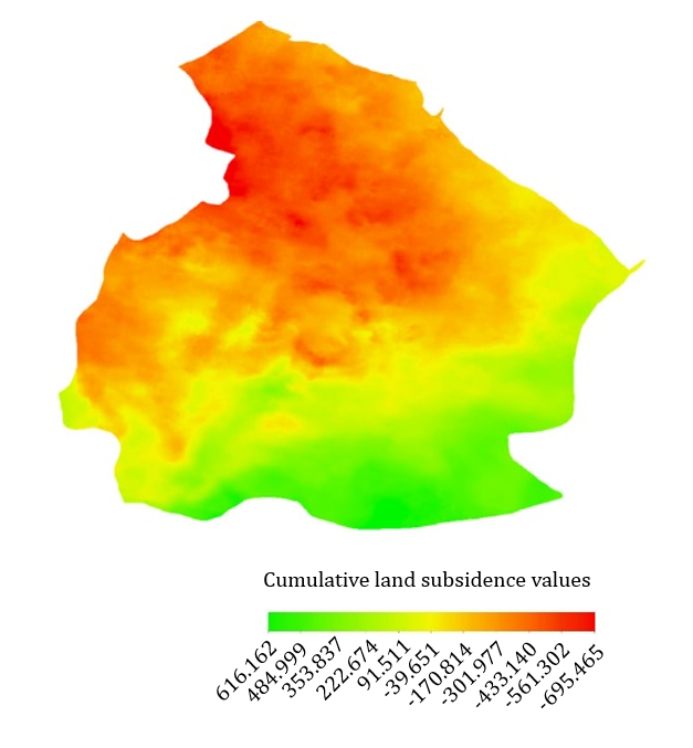
Figure 1) Cumulative land subsidence values calculated in the Bouin-Zahra region, expressed in millimeters (2019–2022).
To examine the relationship between subsidence and groundwater level decline, data from 156 wells during 2019–2024 were analyzed (Figure 2). Interpolation results (Figures 3 and 4) showed that the western part experienced the greatest water table drop, with an average decline of 6 m in the central area and 10.65 m in the west, representing a 77.5% higher decrease in the western region.
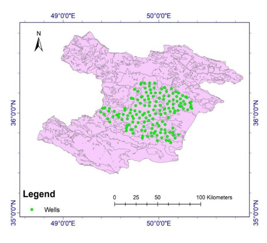
Figure 2) Location of existing wells in the study area and their spatial distribution
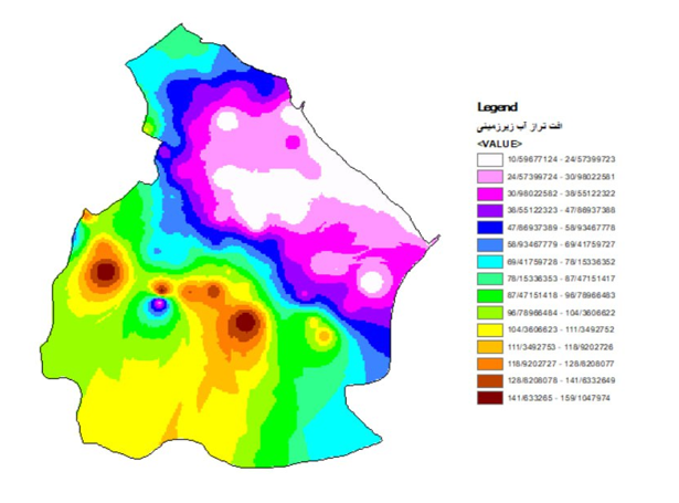
Figure 3) Interpolated groundwater table levels during 2019–2024
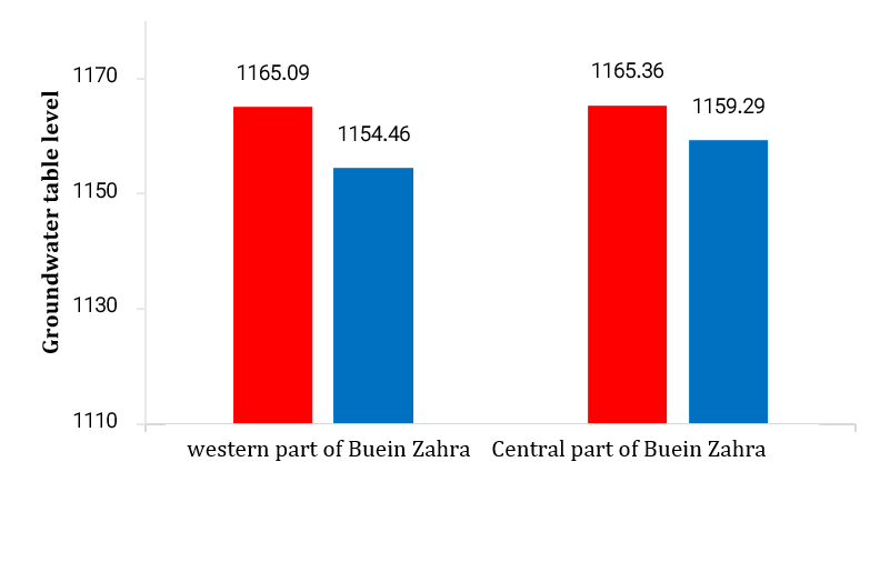
Figure 4) Groundwater table levels in the study area during 2019–2024
Fault mapping (Figure 5) revealed high fault density in the southern and southwestern parts of the plain, which may exacerbate subsidence due to reduced mechanical resistance and increased hydraulic conductivity. Land-use analysis (Figure 6) indicated that northern areas are primarily agricultural and experienced the highest subsidence, whereas southern residential areas, located near faults, face elevated risk of ground movement damage.
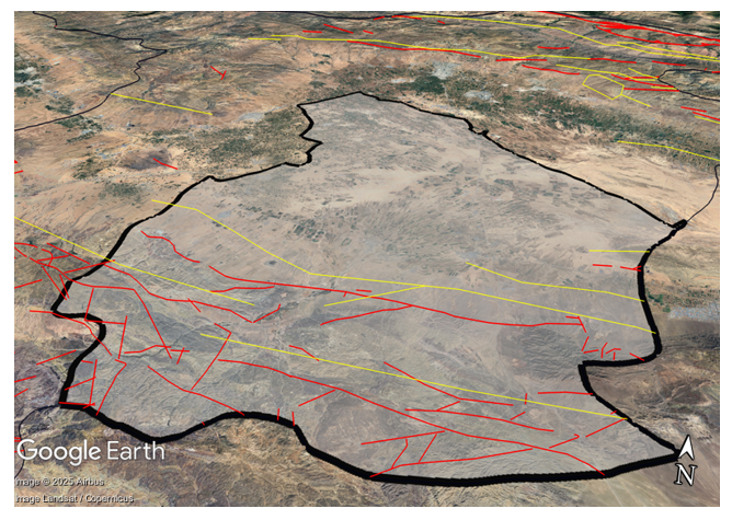
Figure 5) Map of existing faults within the study area
The global water scarcity crisis and the overexploitation of groundwater resources in arid regions, particularly in Iran, have led to the widespread occurrence of land subsidence. The Buein Zahra plain in Qazvin Province represents one of the critical areas, experiencing severe subsidence along with extensive environmental and infrastructural consequences.
Previous Studies
Previous studies have extensively examined the relationship between excessive groundwater extraction and the occurrence of land subsidence. Galloway and Burbey (2011) have identified subsidence as a direct result of reduced pressure in alluvial aquifers due to overextraction. Faso et al. (2020), in a United Nations report, highlight unsustainable groundwater withdrawal and climate change as key accelerators of global subsidence. In Iran, multiple studies, including Motagh et al. (2008) and Hosseini-Moghari et al. (2020), emphasize the role of declining water tables and improper aquifer exploitation in increasing subsidence rates across the country’s plains. Shadfar et al. (2016) have reported the impact of unsustainable extraction on sinkhole formation, while Pourghasemi et al. (2018), through subsidence hazard zoning in Buin Zahra, have identified a substantial portion of the city at high risk. Additionally, Galoie and Motamedi (2022) have investigated runoff management strategies aimed at restoring groundwater levels in this province.
Aim(s)
The aim of the present study was to investigate the impact of excessive groundwater extraction on the rate of land subsidence.
Research Type
The present study was applied research.
Research Society, Place and Time
This study was an applied research conducted in 2025. The research population comprised satellite data related to the Qazvin Plain, particularly the Buin Zahra area in the southern part of Qazvin Province. The study area is classified climatically as a relatively hot and dry region with an average annual rainfall of about 220 mm. The data used included 16 Sentinel-1 satellite images from 2019 to 2022.
Sampling Method and Number
In this study, purposeful sampling was employed to select satellite data with high quality and adequate spatial coverage. The samples consisted of 16 Sentinel-1 satellite images with VV polarization of the GUNW (Geocoded Unwrapped Interferogram) type. These images, spanning 2019 to 2022, were chosen to accurately capture the spatial and temporal variations of land subsidence. The data were obtained from the Alaska Satellite Facility and NASA’s ARIA project.
Used Devices & Materials
In this study, remote sensing data and tools were used to analyze land subsidence. The primary materials and equipment included Sentinel-1 satellite images with VV polarization of the GUNW type (Geocoded Unwrapped products). These data were obtained from the Alaska Satellite Facility (ASF) and NASA’s ARIA project. For data processing and analysis, JPL ISCE2 software (version 2.3.2) was used to extract SAR data, and ESA SNAP was employed for geometric correction and calculation of vertical ground displacements. Additionally, geotechnical logs and quantitative groundwater level data were utilized to validate the results. Interferometric Synthetic Aperture Radar (InSAR) was applied as the main analytical method to determine the rate and spatial extent of subsidence in the study area.
Findings
The SNAP software outputs (version 11.0.0) were imported into ArcGIS (version 10.8.2) to produce maps of land subsidence rates and spatial distribution (Figure 1). Results indicated that the highest subsidence occurred in the northern and western parts of the Buein-Zahra region, with a cumulative maximum deformation of 695 mm between 2019 and 2022 and an average annual rate of approximately 200 mm. The deformation range varied between +616 mm and −695 mm, indicating both uplift and sinking movements.
Figure 1) Cumulative land subsidence values calculated in the Bouin-Zahra region, expressed in millimeters (2019–2022).
To examine the relationship between subsidence and groundwater level decline, data from 156 wells during 2019–2024 were analyzed (Figure 2). Interpolation results (Figures 3 and 4) showed that the western part experienced the greatest water table drop, with an average decline of 6 m in the central area and 10.65 m in the west, representing a 77.5% higher decrease in the western region.
Figure 2) Location of existing wells in the study area and their spatial distribution
Figure 3) Interpolated groundwater table levels during 2019–2024
Figure 4) Groundwater table levels in the study area during 2019–2024
Fault mapping (Figure 5) revealed high fault density in the southern and southwestern parts of the plain, which may exacerbate subsidence due to reduced mechanical resistance and increased hydraulic conductivity. Land-use analysis (Figure 6) indicated that northern areas are primarily agricultural and experienced the highest subsidence, whereas southern residential areas, located near faults, face elevated risk of ground movement damage.
Figure 5) Map of existing faults within the study area
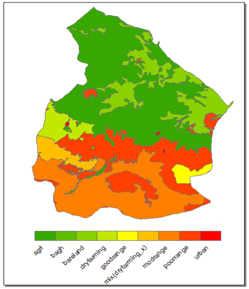
Figure 6) Land use map of the study plain (green in the north: agricultural; red in the south: urban)
Main Comparisons to Similar Studies
The findings of this study are largely consistent with previous research and confirm the increasing trend of land subsidence in the Qazvin Plain. Specifically, Babaee et al. (2020) have reported an average subsidence rate of 40–65 mm per year, whereas the present study indicated a rate of approximately 200 mm per year in recent years, reflecting a significant intensification of the phenomenon. Nouri Qeydari (2014) also reports a maximum subsidence of around 83.4 mm per year, emphasizing the role of fine-grained soils and groundwater table decline. More recent studies, including Janbaz Fotamy et al. (2023) with a rate of 470 mm per year and Farshbaf et al. (2024) with 132 mm per year, further confirm the acceleration of subsidence. Likewise, Moghaddam & Kholghi (2025) have documented a groundwater level decline of over 18 meters over the past two decades. Collectively, these comparisons strongly indicate a close correlation between excessive groundwater extraction and the accelerated rate of subsidence in the Qazvin region.
Suggestions
Effective monitoring and control of groundwater extraction, particularly in subsidence-prone areas, is essential to prevent unauthorized or excessive withdrawals from wells. Additionally, careful and continuous planning to restrict construction in areas with high subsidence rates and to optimize the use of groundwater resources constitutes a key measure to prevent damage to infrastructure and avert crises resulting from this phenomenon.
Conclusion
Groundwater levels in the western parts of the Buein-Zahra region have declined more than in the central areas. Additionally, the highest land subsidence occurs in the northern and western sections, which is directly associated with the decrease in groundwater levels in these areas.
Acknowledgments: To analyze groundwater fluctuations, long-term well data from the Bouin Zahra region were utilized. The authors wish to express their sincere gratitude to the research team, especially the esteemed Dr. Artemis Mo’tamedi, for her continuous support which played a pivotal role in completing this study, and to the Qazvin Regional Water Authority for providing the necessary data and information.
Ethical Permission: This article has not been published in any domestic or international journals.
Conflict of Interest: The authors declare no conflicts of interest with any organizations or individuals. The purpose of this paper is solely to present practical methods in the field of Geographic Information Systems (GIS) and their effective application in environmental hazard analysis.
Author Contributions: Soltani Samet MM (first author), Methodologist/Principal Researcher (35%); Soltani H (second author), Introduction Writer/Assistant Researcher/Statistical Analyst (35%); Galoie M (third author), Methodologist / Discussion Writer (30%)
Funding: This study was conducted based on the research activities of two undergraduate students at the Buein Zahra Technical and Engineering Center and their personal interest. No formal financial support was provided by any official organizations or executive bodies.
Keywords:
References
1. Angornai S, Memarian H, Shariat Panahi M, Bolourchi MJ (2016). Dynamic modeling of land subsidence in Tehran plain. Scientific Quarterly Journal of GeoScience. 25(97):211-220. [Persian] [Link]
2. Azarakhsh Z, Azadbakht M, Matkan A (2022). Estimation, modeling, and prediction of land subsidence using Sentinel-1 time series in Tehran-Shahriar plain: A machine learning-based investigation. Remote Sensing Applications: Society and Environment. 25:100691. [Link] [DOI:10.1016/j.rsase.2021.100691]
3. Babaee S, Mousavi Z, Masoumi Z, Hojati Malekshah A, Roostaei M, Aflaki M (2020). Land subsidence from interferometric SAR and groundwater patterns in the Qazvin plain, Iran. International Journal of Remote Sensing. 41(12):4780-4798. [Link] [DOI:10.1080/01431161.2020.1724345]
4. Buzzanga B, Bekaert DP, Hamlington BD, Sangha SS (2020). Toward sustained monitoring of subsidence at the coast using InSAR and GPS: An application in Hampton Roads, Virginia. Geophysical Research Letters. 47(18):e2020GL090013. [Link] [DOI:10.1029/2020GL090013]
5. Costantini M (2002). A novel phase unwrapping method based on network programming. IEEE Transactions on Geoscience and Remote Sensing. 36(3):813-821. [Link] [DOI:10.1109/36.673674]
6. Dai K, Liu G, Li Z, Li T, Yu B, Wang X, et al (2015). Extracting vertical displacement rates in Shanghai (China) with multi-platform SAR images. Remote Sensing. 7(8):9542-9562. [Link] [DOI:10.3390/rs70809542]
7. Farshbaf A, Mousavi MN, Shahnazi S (2024). Vulnerability assessment of power transmission towers affected by land subsidence via interferometric synthetic aperture radar technique and finite element method analysis: A case study of Zanjan and Qazvin provinces. Environment, Development and Sustainability. 26(4):10845-10864. [Link] [DOI:10.1007/s10668-023-03127-x]
8. Faso B, Verde C, Rica C, Salvador E, Islands M, Guinea PN, et al (2020). Midterm comprehensive review of the implementation of the international decade for action, "water for sustainable development", 2018-2028. New York: United Nations. [Link]
9. Galloway DL, Burbey TJ (2011). Regional land subsidence accompanying groundwater extraction. Hydrogeology Journal. 19(8):1459-1486. [Link] [DOI:10.1007/s10040-011-0775-5]
10. Galoie M, Motamedi A (2022). Modeling infiltration management in a watershed using SWAT software and investigating the impact of groundwater levels: Qazvin province. Report of Shared Project between Vice presidency of Iran and Science Ministry of China. [Link]
11. Gholamian F, Mousavi Z (2016). Assessment of decreasing rate of groundwater and earth surface subsidence by using GRACE satellite and InSAR data (Qazvin plain). Proceedings of the 17th Iranian Geophysical conference; 2016 May 10-12; Tehran, Iran. Tehran: Shahid Beheshti press. [persian] [Link]
12. Haghshenas Haghighi M, Motagh M (2024). Uncovering the impacts of depleting aquifers: A remote sensing analysis of land subsidence in Iran. Science Advances. 10(19). [Link] [DOI:10.1126/sciadv.adk3039]
13. Hanssen RF (2001). Radar interferometry: Data interpretation and error analysis. Dordrecht: Springer. [Link] [DOI:10.1007/0-306-47633-9]
14. Hosseini-Moghari SM, Araghinejad S, Tourian MJ, Ebrahimi K, Döll P (2020). Quantifying the impacts of human water use and climate variations on recent drying of Lake Urmia basin: The value of different sets of spaceborne and in situ data for calibrating a global hydrological model. Hydrology and Earth System Sciences. 24(4):1939-1956. [Link] [DOI:10.5194/hess-24-1939-2020]
15. ILNA News Agency (2022). Reports in "subsidence in Qazvin plain" [Internet]. Tehran: Iranian Labour News Agency [cited 2021 July 24th]. Available from: https://www.ilna.ir/. [Persian] [Link]
16. Iran Ministry of Energy (2022). Report on the status of forbidden and free plains of Iran. Water Resources Management Company, Tehran. [Link]
17. Janbaz Fotamy M, Kholghi M, Abdeh Kolahchi A, Roostaei M (2020). Land subsidence assessment due to groundwater exploration by using differential radar interferometry technique, case study: Qazvin province. Iran-Water Resources Research. 16(3):133-147. [Persian] [Link]
18. Janbaz Fotamy M, Kholghi M, Abdeh Kolahchi A, Roostaei M (2023). The performance of the evidence weighting in GIS for determining the effective factors on the land subsidence in Qazvin Plain. Iran-Water Resources Research. 19(3):118-135. [Persian] [Link]
19. Kaplan G, Fine L, Lukyanov V, Manivasagam VS, Tanny J, Rozenstein O (2021). Normalizing the local incidence angle in sentinel-1 imagery to improve leaf area index, vegetation height, and crop coefficient estimations. Land. 10(7):680. [Link] [DOI:10.3390/land10070680]
20. Moghaddam N, Kholghi M (2025). Analysis of groundwater table decline and salinity intensification in the Qazvin Plain: Implications from a water resources governance perspective. Iranian Journal of Irrigation & Drainage. 19(3):469-487. [Persian] [Link]
21. Motagh M, Walter TR, Sharifi MA, Fielding E, Schenk A, Anderssohn J, et al (2008). Land subsidence in Iran caused by widespread water reservoir overexploitation. Geophysical Research Letters. 35(16). [Link] [DOI:10.1029/2008GL033814]
22. Nouri Qeydari R (2014). Study of land subsidence and its prediction in the Qazvin Plain [dissertation]. Damghan: University of Science & Basic Research Damghan. [Persian] [Link]
23. Pourghasemi HR, Mohseni Saravi M (2018). Land-subsidence spatial modeling using generalized additive model data mining technique. Watershed Management Research. 30(4):20-34. [Persian] [Link]
24. Rosen PA, Gurrola E, Sacco GF, Zebker H (2012). The InSAR scientific computing environment. Proceedings of the 9th European Conference on Synthetic Aperture Radar. Nuremberg: VDE. p. 730-733. [Link]
25. Shadfar S, Nasiri E, Chitgar S, Ahmadi A (2016). Hazard zonation of land subsidence using analytical hierarchy process (AHP) case study (city of Buin Zahra). Geographical Journal of Territory. 12(48):101-116. [Persian] [Link]
26. Tatar M, Jackson J, Hatzfeld D, Bergman E (2007). The 2004 May 28 Baladeh earthquake (M w 6.2) in the Alborz, Iran: Overthrusting the South Caspian Basin margin, partitioning of oblique convergence and the seismic hazard of Tehran. Geophysical Journal International. 170(1):249-261. [Link] [DOI:10.1111/j.1365-246X.2007.03386.x]
27. Xu Y, Wu Z, Zhang H, Liu J, Jing Z (2023). Land subsidence monitoring and building risk assessment using InSAR and machine learning in a Loess Plateau City-A case study of Lanzhou, China. Remote Sensing. 15(11):2851. [Link] [DOI:10.3390/rs15112851]
28. Yuan M, Li M, Liu H, Lv P, Li B, Zheng W (2021). Subsidence monitoring base on SBAS-InSAR and slope stability analysis method for damage analysis in mountainous mining subsidence regions. Remote Sensing. 13(16):3107. [Link] [DOI:10.3390/rs13163107]