
Bilingual
En/Fa
Geographical Research is Published in both Persian and English Full-text.
Volume 40, Issue 1 (2025)
GeoRes 2025, 40(1): 73-83 |
Back to browse issues page
Article Type:
Subject:


History
Received: 2025/02/1 | Accepted: 2025/03/10 | Published: 2025/03/15
Received: 2025/02/1 | Accepted: 2025/03/10 | Published: 2025/03/15
How to cite this article
Aryanpooya M, Pazhouhan I. Environmental Capability Assessment of the Arasbaran Forests for Ecotourism Development Using the Multi-Criteria Evaluation Model. GeoRes 2025; 40 (1) :73-83
URL: http://georesearch.ir/article-1-1710-en.html
URL: http://georesearch.ir/article-1-1710-en.html
Download citation:
BibTeX | RIS | EndNote | Medlars | ProCite | Reference Manager | RefWorks
Send citation to:


Rights and permissions
BibTeX | RIS | EndNote | Medlars | ProCite | Reference Manager | RefWorks
Send citation to:

Authors
M. Aryanpooya1, I. Pazhouhan *1
1- Department of Nature Engineering, Faculty of Natural Resources and Environment, Malayer University, Malayer, Iran
Full-Text (HTML) (277 Views)
Background
The increasing human pressure on natural resources and the degradation of ecosystems have highlighted the necessity of sustainable utilization of these resources. In this context, ecotourism has emerged as an effective strategy for sustainable development and environmental conservation. However, in high-value areas such as the Arasbaran forests, a comprehensive scientific assessment of ecotourism potential has not yet been thoroughly conducted.
Previous Studies
Previous studies have shown that integrating Multi-Criteria Evaluation (MCE) models with Geographic Information Systems (GIS) provides an effective tool for identifying areas suitable for ecotourism. For example, Qureshi and colleagues used the AHP model and GIS in northern India to analyze ecotourism site selection based on indicators such as topography, vegetation cover, and accessibility [Sahani, 2020]. Cengiz and colleagues, in the coastal regions of Turkey, applied a fuzzy AHP model and emphasized the importance of environmental and human factors [Cengiz et al., 2020]. Likewise, Yasin and Woldemariam in Ethiopia, and Chandel and colleagues in Ghana, used the MCE and GIS approach to identify and prioritize potential ecotourism areas [Yasin & Woldemariam, 2023; Chandel et al., 2023]. In Iran, several studies have also been conducted in this field; however, regarding the Arasbaran forests, few studies have specifically focused on ecotourism evaluation using multi-criteria decision-making models [Ahmadi Sani et al., 2011; Yekani et al., 2016].
Aim(s)
The present study was conducted with the aim of assessing the environmental capacity of the Arasbaran forests from an ecotourism perspective, utilizing a Multi-Criteria Evaluation (MCE) model within a GIS environment. By simultaneously analyzing physical, environmental, and infrastructural factors, the study sought to provide an accurate map of areas suitable for ecotourism development.
Research Type
The present study was applied research.
Research Society, Place and Time
This study was conducted in 2023 (year 1402 in the Iranian calendar) in the Arasbaran Forest region, located in northwest Iran and registered on the UNESCO Biosphere Reserves list. The study population included areas with ecotourism potential in this region, characterized by high biodiversity, stunning natural landscapes, and significant cultural and historical values.
Sampling Method and Number
Nothing is mentioned in the article.
Used Devices & Materials
In this study, GIS software version 10.7 was used for spatial analysis and modeling of the ecotourism capacity of the Arasbaran region, enabling the processing, integration, and analysis of various information layers. The digital layers utilized included topographic maps, land use, vegetation cover, distance from roads and villages, protected areas, tourist attractions, fault lines, and water resources, collected from sources such as the National Cartographic Center, the East Azerbaijan Environmental Protection Agency, and the Forests and Rangelands Organization. Additionally, climatic data such as average rainfall and temperature were obtained through secondary and library sources. For developing the multi-criteria decision-making model, the Fuzzy AHP and WLC methods were employed. Pairwise comparison data were collected via specialized questionnaires distributed among 14 experts. In the criterion standardization phase, fuzzy membership functions were applied to normalize data within the range of 0 to 1.
Findings by Text
In this study, various sub-criteria related to ecotourism development were first standardized using fuzzy logic so that all values ranged between 0 and 1; values closer to 1 indicated higher suitability for ecotourism development. The results showed that among the physical criteria, indicators such as slope, distance to rivers, and soil texture generally had higher suitability in the central and southern parts of the region. For biological criteria, vegetation density and proximity to protected areas were more prominent in the eastern and northern zones. Regarding infrastructural criteria, areas adjacent to roads and tourist attractions received higher scores (Figure 3).
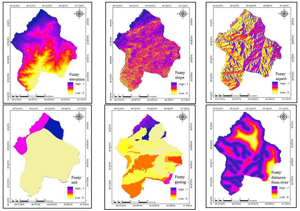
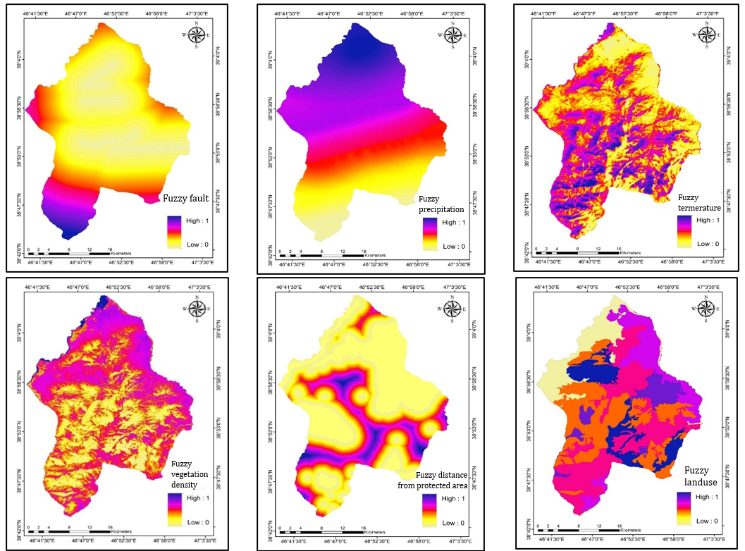
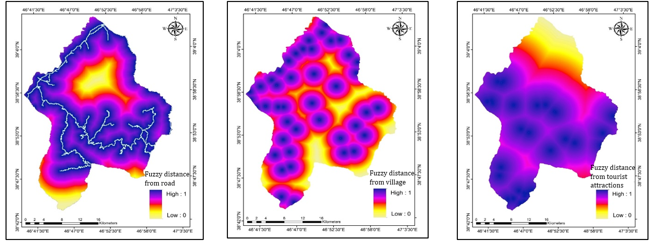
Figure 3. Standardized (Fuzzy) map of the research sub-criteria
Next, using the Fuzzy Analytic Hierarchy Process (FAHP), the weights of the main criteria3-physical environment, biological environment, and infrastructure-were calculated. The physical environment criterion had the highest importance for assessing the ecological capacity for ecotourism development with a normalized weight of 0.579. This was followed by the biological environment (0.251) and infrastructural environment (0.168) (Figure 4).
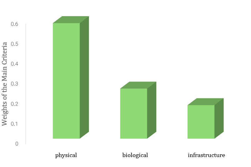
Figure 4. Fuzzy weights of the main (environmental) criteria in the ecological capability assessment of the region with an ecotourism approach
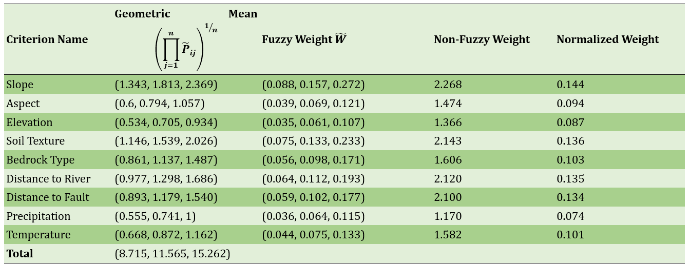
For the physical sub-criteria, slope had the greatest influence with a normalized weight of 0.144. Following slope, soil texture, distance to rivers, and distance to fault lines had significant weights of 0.136, 0.135, and 0.134, respectively. In contrast, precipitation and elevation had the lowest weights (Table 1).
Table 1. Fuzzy and non-fuzzy weights of physical sub-criteria
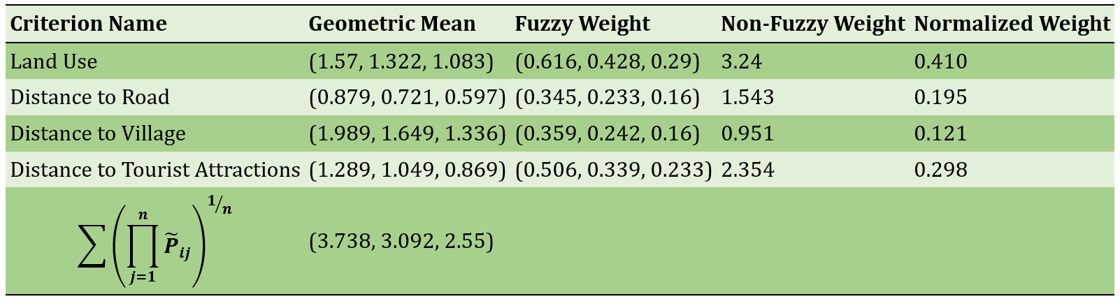
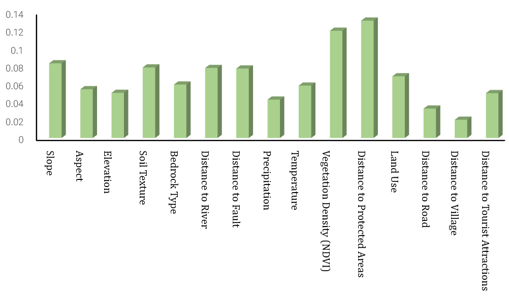
In the biological category, distance to protected areas (0.522) was more important than vegetation density (0.477) (Table 2). Among infrastructural sub-criteria (Table 3), land use had the highest weight (0.410), while distance to villages had the lowest importance (0.121). The final weight of each sub-criterion was calculated by multiplying the main criterion weight by the normalized weight of the sub-criterion (Figure 5).
Table 2. Fuzzy and non-fuzzy weights of the biological sub-criteria
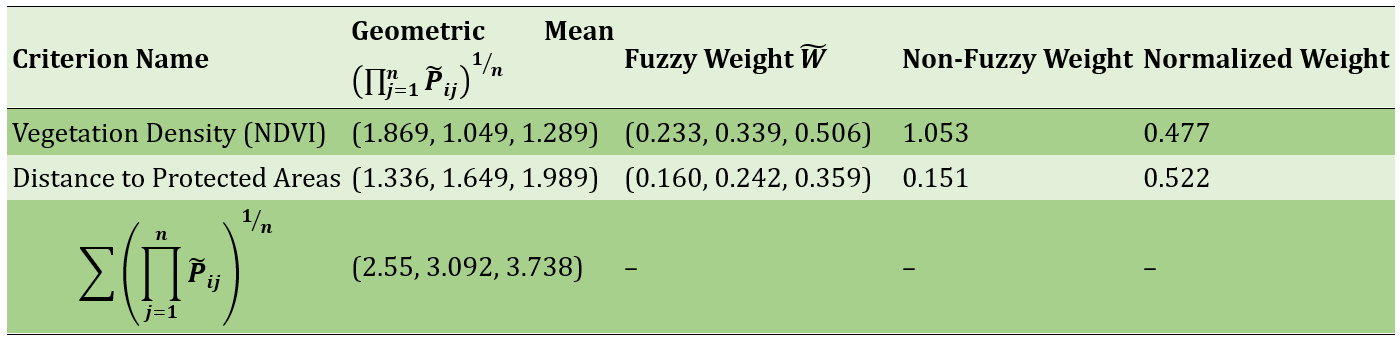
Table 3. Fuzzy and non-fuzzy weights of infrastructure sub-criteria
To identify areas with limitations for ecotourism development, Boolean maps were prepared. Restriction maps were created only for slope, rivers, protected areas, and faults layers, which were then integrated using the AND operator in GIS. The outcome, shown in Figure 6-a, indicates that 444.05 km² (about 59.97%) of the area has development restrictions, while only 296.7 km² (40.02%) is unrestricted.
In the final step, using the Weighted Linear Combination (WLC) model based on the fuzzified layers, the final ecotourism capacity map of the region was produced (Figure 6-b) and classified into four categories: unsuitable, restricted, moderately suitable, and fully suitable (Figure 6-c). Combining this map with the Boolean restriction map resulted in the final ecotourism zoning map (Figure 6-d). The results revealed that about 63% of the region lacks suitable capacity for ecotourism, 23% falls into the moderately suitable category, and only 14% is fully suitable for ecotourism development.
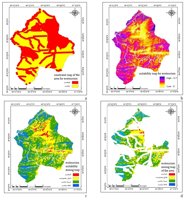
Figure 6) a) Final constraint map of the area for ecotourism, b) Final fuzzy suitability map for ecotourism in the study area, c) Final ecotourism suitability zoning map of the study area, and d) Final ecotourism zoning map of the area with unsuitable zones excluded.
Main Comparisons to Similar Studies
The findings of the present study, indicating that only about 14% of the land in the Arasbaran protected area is fully suitable for ecotourism, align with the results of similar studies, including those by Zarabi and SafarAbadi (2014) and Abdollahi et al. (2012), which also have reported limited proportions of land suitable for ecotourism (ranging from 6% to 17%). Furthermore, a large portion of the area, approximately 63%, has severe limitations or lacks the capacity for ecotourism development, which is consistent with the findings of Amiri et al. (2015) and Khalili et al. (2014). From an international perspective, the proportion of suitable land reported in this study is lower than that reported by Ferrel & Marion (2001) for the forests of Costa Rica (around 40%), a difference likely attributable to variations in physiographic, climatic, and infrastructural conditions. Nevertheless, in line with studies such as Bhuiyan et al. (2011) and Hernandez et al. (2018), the present research also emphasizes the importance of sustainable management, environmental education, and ecological capacity assessment for successful ecotourism development.
Suggestions
o promote sustainable ecotourism, the region requires detailed biophysical studies, environmental education for locals and tourists, community-based ecotourism models, a prioritized development-conservation zoning plan, and post-evaluation mechanisms to monitor tourism impacts.
Conclusion
Only a small portion of the Arasbaran forests is classified as "highly suitable" for ecotourism development, while more than half of the area lacks ecotourism potential. Physical and biological environmental criteria had the greatest influence on the region’s ecotourism suitability assessment.
Acknowledgments: The authors express their sincere gratitude to the East Azerbaijan Province Department of Forests and Rangelands for their cooperation and for providing the necessary data.
Ethical Permission: None reported by the authors.
Conflict of Interest: None reported by the authors.
Authors’ Contributions: Aryanpooya M (First author), Main Researcher, Discussion Writer (50%); Pazhouhan I (Second author), Assisstant Researcher/ Methodologist (50%).
Funding: None reported by the authors.
The increasing human pressure on natural resources and the degradation of ecosystems have highlighted the necessity of sustainable utilization of these resources. In this context, ecotourism has emerged as an effective strategy for sustainable development and environmental conservation. However, in high-value areas such as the Arasbaran forests, a comprehensive scientific assessment of ecotourism potential has not yet been thoroughly conducted.
Previous Studies
Previous studies have shown that integrating Multi-Criteria Evaluation (MCE) models with Geographic Information Systems (GIS) provides an effective tool for identifying areas suitable for ecotourism. For example, Qureshi and colleagues used the AHP model and GIS in northern India to analyze ecotourism site selection based on indicators such as topography, vegetation cover, and accessibility [Sahani, 2020]. Cengiz and colleagues, in the coastal regions of Turkey, applied a fuzzy AHP model and emphasized the importance of environmental and human factors [Cengiz et al., 2020]. Likewise, Yasin and Woldemariam in Ethiopia, and Chandel and colleagues in Ghana, used the MCE and GIS approach to identify and prioritize potential ecotourism areas [Yasin & Woldemariam, 2023; Chandel et al., 2023]. In Iran, several studies have also been conducted in this field; however, regarding the Arasbaran forests, few studies have specifically focused on ecotourism evaluation using multi-criteria decision-making models [Ahmadi Sani et al., 2011; Yekani et al., 2016].
Aim(s)
The present study was conducted with the aim of assessing the environmental capacity of the Arasbaran forests from an ecotourism perspective, utilizing a Multi-Criteria Evaluation (MCE) model within a GIS environment. By simultaneously analyzing physical, environmental, and infrastructural factors, the study sought to provide an accurate map of areas suitable for ecotourism development.
Research Type
The present study was applied research.
Research Society, Place and Time
This study was conducted in 2023 (year 1402 in the Iranian calendar) in the Arasbaran Forest region, located in northwest Iran and registered on the UNESCO Biosphere Reserves list. The study population included areas with ecotourism potential in this region, characterized by high biodiversity, stunning natural landscapes, and significant cultural and historical values.
Sampling Method and Number
Nothing is mentioned in the article.
Used Devices & Materials
In this study, GIS software version 10.7 was used for spatial analysis and modeling of the ecotourism capacity of the Arasbaran region, enabling the processing, integration, and analysis of various information layers. The digital layers utilized included topographic maps, land use, vegetation cover, distance from roads and villages, protected areas, tourist attractions, fault lines, and water resources, collected from sources such as the National Cartographic Center, the East Azerbaijan Environmental Protection Agency, and the Forests and Rangelands Organization. Additionally, climatic data such as average rainfall and temperature were obtained through secondary and library sources. For developing the multi-criteria decision-making model, the Fuzzy AHP and WLC methods were employed. Pairwise comparison data were collected via specialized questionnaires distributed among 14 experts. In the criterion standardization phase, fuzzy membership functions were applied to normalize data within the range of 0 to 1.
Findings by Text
In this study, various sub-criteria related to ecotourism development were first standardized using fuzzy logic so that all values ranged between 0 and 1; values closer to 1 indicated higher suitability for ecotourism development. The results showed that among the physical criteria, indicators such as slope, distance to rivers, and soil texture generally had higher suitability in the central and southern parts of the region. For biological criteria, vegetation density and proximity to protected areas were more prominent in the eastern and northern zones. Regarding infrastructural criteria, areas adjacent to roads and tourist attractions received higher scores (Figure 3).
Figure 3. Standardized (Fuzzy) map of the research sub-criteria
Next, using the Fuzzy Analytic Hierarchy Process (FAHP), the weights of the main criteria3-physical environment, biological environment, and infrastructure-were calculated. The physical environment criterion had the highest importance for assessing the ecological capacity for ecotourism development with a normalized weight of 0.579. This was followed by the biological environment (0.251) and infrastructural environment (0.168) (Figure 4).
Figure 4. Fuzzy weights of the main (environmental) criteria in the ecological capability assessment of the region with an ecotourism approach
For the physical sub-criteria, slope had the greatest influence with a normalized weight of 0.144. Following slope, soil texture, distance to rivers, and distance to fault lines had significant weights of 0.136, 0.135, and 0.134, respectively. In contrast, precipitation and elevation had the lowest weights (Table 1).
Table 1. Fuzzy and non-fuzzy weights of physical sub-criteria
In the biological category, distance to protected areas (0.522) was more important than vegetation density (0.477) (Table 2). Among infrastructural sub-criteria (Table 3), land use had the highest weight (0.410), while distance to villages had the lowest importance (0.121). The final weight of each sub-criterion was calculated by multiplying the main criterion weight by the normalized weight of the sub-criterion (Figure 5).
Table 2. Fuzzy and non-fuzzy weights of the biological sub-criteria
Table 3. Fuzzy and non-fuzzy weights of infrastructure sub-criteria
To identify areas with limitations for ecotourism development, Boolean maps were prepared. Restriction maps were created only for slope, rivers, protected areas, and faults layers, which were then integrated using the AND operator in GIS. The outcome, shown in Figure 6-a, indicates that 444.05 km² (about 59.97%) of the area has development restrictions, while only 296.7 km² (40.02%) is unrestricted.
In the final step, using the Weighted Linear Combination (WLC) model based on the fuzzified layers, the final ecotourism capacity map of the region was produced (Figure 6-b) and classified into four categories: unsuitable, restricted, moderately suitable, and fully suitable (Figure 6-c). Combining this map with the Boolean restriction map resulted in the final ecotourism zoning map (Figure 6-d). The results revealed that about 63% of the region lacks suitable capacity for ecotourism, 23% falls into the moderately suitable category, and only 14% is fully suitable for ecotourism development.
Figure 6) a) Final constraint map of the area for ecotourism, b) Final fuzzy suitability map for ecotourism in the study area, c) Final ecotourism suitability zoning map of the study area, and d) Final ecotourism zoning map of the area with unsuitable zones excluded.
Main Comparisons to Similar Studies
The findings of the present study, indicating that only about 14% of the land in the Arasbaran protected area is fully suitable for ecotourism, align with the results of similar studies, including those by Zarabi and SafarAbadi (2014) and Abdollahi et al. (2012), which also have reported limited proportions of land suitable for ecotourism (ranging from 6% to 17%). Furthermore, a large portion of the area, approximately 63%, has severe limitations or lacks the capacity for ecotourism development, which is consistent with the findings of Amiri et al. (2015) and Khalili et al. (2014). From an international perspective, the proportion of suitable land reported in this study is lower than that reported by Ferrel & Marion (2001) for the forests of Costa Rica (around 40%), a difference likely attributable to variations in physiographic, climatic, and infrastructural conditions. Nevertheless, in line with studies such as Bhuiyan et al. (2011) and Hernandez et al. (2018), the present research also emphasizes the importance of sustainable management, environmental education, and ecological capacity assessment for successful ecotourism development.
Suggestions
o promote sustainable ecotourism, the region requires detailed biophysical studies, environmental education for locals and tourists, community-based ecotourism models, a prioritized development-conservation zoning plan, and post-evaluation mechanisms to monitor tourism impacts.
Conclusion
Only a small portion of the Arasbaran forests is classified as "highly suitable" for ecotourism development, while more than half of the area lacks ecotourism potential. Physical and biological environmental criteria had the greatest influence on the region’s ecotourism suitability assessment.
Acknowledgments: The authors express their sincere gratitude to the East Azerbaijan Province Department of Forests and Rangelands for their cooperation and for providing the necessary data.
Ethical Permission: None reported by the authors.
Conflict of Interest: None reported by the authors.
Authors’ Contributions: Aryanpooya M (First author), Main Researcher, Discussion Writer (50%); Pazhouhan I (Second author), Assisstant Researcher/ Methodologist (50%).
Funding: None reported by the authors.