
Bilingual
En/Fa
Geographical Research is Published in both Persian and English Full-text.
Volume 39, Issue 3 (2024)
GeoRes 2024, 39(3): 387-398 |
Back to browse issues page
Article Type:
Subject:


History
Received: 2024/08/22 | Accepted: 2024/10/26 | Published: 2024/11/26
Received: 2024/08/22 | Accepted: 2024/10/26 | Published: 2024/11/26
How to cite this article
Rezaeeparto K. Vulnerability of the Southern Areas of Tehran City to Earthquake Using Layer Overlay System. GeoRes 2024; 39 (3) :387-398
URL: http://georesearch.ir/article-1-1639-en.html
URL: http://georesearch.ir/article-1-1639-en.html
Download citation:
BibTeX | RIS | EndNote | Medlars | ProCite | Reference Manager | RefWorks
Send citation to:


Rights and permissions
BibTeX | RIS | EndNote | Medlars | ProCite | Reference Manager | RefWorks
Send citation to:

Authors
K. Rezaeeparto *
Earth Science Research Division, Research Institute of Petroleum Industry, Tehran, Iran
Full-Text (HTML) (1365 Views)
Background
With the expansion of urbanization and the concentration of population and human activities in urban areas, cities have become highly vulnerable to natural disasters, especially earthquakes. Unplanned urban growth, unstable constructions, and high population density have increased the level of risk. Tehran, due to its location on active fault lines, is considered one of the highly seismic regions, and the need for physical planning to reduce its vulnerability is of critical importance.
Previous Studies
Previous studies have highlighted the role of information and communication technology (ICT) in urban management and enhancing resilience against hazards (Deakin & Allwinkle, 2007; Gil-García & Pardo, 2005). Some research has emphasized the importance of identifying factors contributing to urban vulnerability as a fundamental step in reducing earthquake-related damages (UNDP-BCPR, 2015; Liang et al., 2019). Additionally, studies such as those conducted by JICA and the Tehran Earthquake Studies Center have assessed the vulnerability of Tehran to earthquake scenarios and have predicted widespread potential damages for the city (Ehsani & Bahmanpour, 2018). Furthermore, certain studies have provided conceptual analyses of vulnerability from structural and social perspectives within urban spaces (Cao & Laflamme, 2017; Ahadnejad et al., 2021). Historical reviews of earthquakes and the risks posed by active faults in the Tehran region have also been documented by numerous researchers (Shieh et al., 2020; Fahim Danesh et al., 2017).
Aim(s)
The aim of the present study was to assess the level of vulnerability of the southern districts of Tehran to the occurrence of earthquakes.
Research Type
The present study was applied in nature.
Research Society, Place and Time
This study was conducted with a developmental approach in the city of Tehran. The target population included the southern districts of Tehran (Districts 9 to 20), which are of high importance due to their proximity to active seismic faults such as the North Tehran, Mosha, Eivank, Rey, and Kahrizak faults [Ehsani & Bahmanpour, 2018; Shieh et al., 2020]. The total area of identified seismic faults within and around Tehran is 80 square kilometers, of which 47 square kilometers are located within the city itself. The primary data for this study were based on spatial-geographic analyses and expert interviews conducted with both domestic and international specialists using the Delphi technique over a 54-day period.
Sampling Method and Number
In this study, purposive sampling was used. The sample consisted of 17 experts, including a combination of 11 domestic specialists and 6 international specialists.
Used Devices & Materials
In this study, a set of specialized tools and resources was used to identify, weight, and analyze the indicators affecting the physical vulnerability of Tehran city to earthquakes. In the first phase, to extract the initial indicators and criteria, written sources, upstream documents, national and international regulations and standards were systematically reviewed and analyzed [Fahim Danesh et al., 2017; Ahadnejad et al., 2021; Behrouzi et al., 2022]. Then, to assess the validity and assign weights to these indicators, a researcher-designed questionnaire with a five-point Likert scale was developed and distributed via a smart webmail system to 17 domestic and international experts. For spatial analysis, preparation of informational layers of the indicators, and production of vulnerability maps, ArcGIS software version 9.2 was used. In the final step, MATLAB software was employed for modeling optimization scenarios and quantitative vulnerability analysis, utilizing an algorithm to examine and adjust indicator values. Additionally, a fuzzy Delphi method involving expert participation was applied to determine the relative importance of the indicators during the weighting process. Together, these tools and methods provided a comprehensive analytical framework for assessing the physical vulnerability of urban areas to earthquake hazards.
Findings by Text
In this study, following the Delphi process with expert participation, 21 key indicators were identified and finalized to assess earthquake-induced vulnerability. These indicators were then weighted using the fuzzy analysis method (Table 1). According to this weighting, indicators such as Peak Ground Acceleration (PGA), building quality, and distance from fault lines held the highest importance in determining the region's vulnerability, while indicators like topography, number of floors, and distance from fire stations had the least impact (Table 1).
Table 1. Fuzzification of factors affecting earthquake vulnerability and their weights
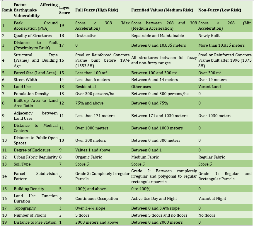
Three fuzzy levels (full fuzzy, medium fuzzy, and non-fuzzy) for each indicator were defined (Table 1). For example, in the Peak Ground Acceleration indicator, scores above 308 were classified as highest risk (full fuzzy), and scores below 268 as lowest risk (non-fuzzy). Alongside the numerical analysis, thematic maps were prepared based on some key indicators to spatially represent the distribution of vulnerability. The vulnerability map based on distance from the fault indicates the highest risk within less than 700 meters from the fault. Areas with high population density exhibit greater vulnerability. Streets narrower than 6 meters pose more hazards. Among land uses, residential areas show the highest vulnerability, while green spaces have the lowest. Distances exceeding 300 meters from public open spaces increase vulnerability, and similarly, greater distances from medical centers correspond to higher vulnerability. Finally, locations more than 2000 meters away from fire stations are classified at the highest vulnerability level (Figure 1).
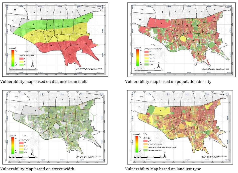
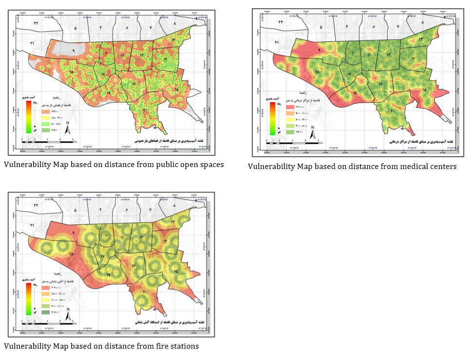
Figure 1. Vulnerability map of the study area based on the examined indicators
Finally, by overlaying the informational layers related to these indicators, the final earthquake vulnerability map of the area was created (Figure 2). This map illustrates that parts of the study area with old buildings, high density, close proximity to faults, narrow streets, and greater distances from emergency centers and open spaces exhibit the highest levels of vulnerability.
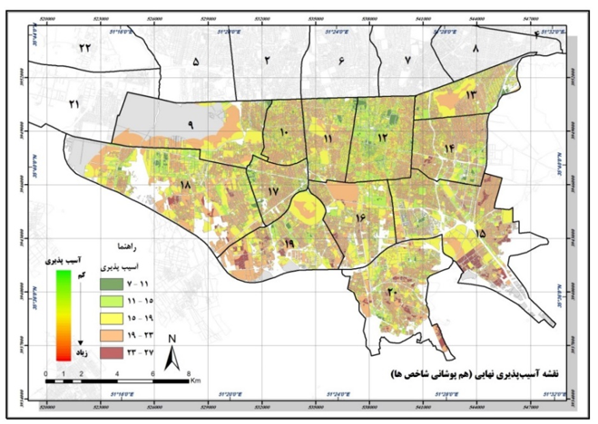
Figure 2. Final vulnerability map of the study area against earthquakes
Main Comparisons to Similar Studies
The findings of this study show significant alignment with the results of previous research. For example, the importance of communication infrastructure in reducing human casualties during crises was also emphasized by Alinia and Khatib (2021). Similarly, the present study, like the research by Cao and Laflamme (2017), highlighted the crucial role of street width, pathway design, and access to open spaces in facilitating rescue and relief operations. Additionally, the findings regarding the adverse effects of small urban plots and fragmentation of open spaces are consistent with those of Habibi et al. (2017) and Mirhosseini et al. (2020). On the other hand, the importance of building materials and the age of structures in increasing vulnerability was noted in the study by Gil-García and Pardo (2005). Furthermore, the negative impacts of high-rise density and tall buildings during earthquakes were also observed in the research by Lotfi et al. (2022). These consistencies enhance the validity and coherence of the present study’s results with the existing literature.
Suggestions
It is recommended that, based on the results derived from this study, actions be taken to eliminate or reduce the negative influencing factors in order to decrease the potential earthquake damages in this part of the city. Additionally, the continuous monitoring of the study area can be implemented through the design of an intelligent system.
Conclusion
The areas examined in this study, due to their diverse and numerous land uses, presence of worn-out and dense urban fabric, and other influencing factors, possess a high potential vulnerability to earthquakes.
Acknowledgments: Special thanks are due to Dr. Mehran Ehsani for his collaboration and expert consultation in the preparation of this article. I also express my sincere gratitude to the Tehran Urban Management Studies Center for providing the geographical layers of Tehran.
Ethical Permission: No ethical code was required for this study.
Conflict of Interest: None reported by the authors.
Authors’ Contributions: Rezaeeparto K (First author), Main Researcher/Introduction Writer/Discussion Writer/Methodologist/Statistical Analyst (100%)
Funding: All expenses were personally covered by the author, with no financial sponsor involved.
With the expansion of urbanization and the concentration of population and human activities in urban areas, cities have become highly vulnerable to natural disasters, especially earthquakes. Unplanned urban growth, unstable constructions, and high population density have increased the level of risk. Tehran, due to its location on active fault lines, is considered one of the highly seismic regions, and the need for physical planning to reduce its vulnerability is of critical importance.
Previous Studies
Previous studies have highlighted the role of information and communication technology (ICT) in urban management and enhancing resilience against hazards (Deakin & Allwinkle, 2007; Gil-García & Pardo, 2005). Some research has emphasized the importance of identifying factors contributing to urban vulnerability as a fundamental step in reducing earthquake-related damages (UNDP-BCPR, 2015; Liang et al., 2019). Additionally, studies such as those conducted by JICA and the Tehran Earthquake Studies Center have assessed the vulnerability of Tehran to earthquake scenarios and have predicted widespread potential damages for the city (Ehsani & Bahmanpour, 2018). Furthermore, certain studies have provided conceptual analyses of vulnerability from structural and social perspectives within urban spaces (Cao & Laflamme, 2017; Ahadnejad et al., 2021). Historical reviews of earthquakes and the risks posed by active faults in the Tehran region have also been documented by numerous researchers (Shieh et al., 2020; Fahim Danesh et al., 2017).
Aim(s)
The aim of the present study was to assess the level of vulnerability of the southern districts of Tehran to the occurrence of earthquakes.
Research Type
The present study was applied in nature.
Research Society, Place and Time
This study was conducted with a developmental approach in the city of Tehran. The target population included the southern districts of Tehran (Districts 9 to 20), which are of high importance due to their proximity to active seismic faults such as the North Tehran, Mosha, Eivank, Rey, and Kahrizak faults [Ehsani & Bahmanpour, 2018; Shieh et al., 2020]. The total area of identified seismic faults within and around Tehran is 80 square kilometers, of which 47 square kilometers are located within the city itself. The primary data for this study were based on spatial-geographic analyses and expert interviews conducted with both domestic and international specialists using the Delphi technique over a 54-day period.
Sampling Method and Number
In this study, purposive sampling was used. The sample consisted of 17 experts, including a combination of 11 domestic specialists and 6 international specialists.
Used Devices & Materials
In this study, a set of specialized tools and resources was used to identify, weight, and analyze the indicators affecting the physical vulnerability of Tehran city to earthquakes. In the first phase, to extract the initial indicators and criteria, written sources, upstream documents, national and international regulations and standards were systematically reviewed and analyzed [Fahim Danesh et al., 2017; Ahadnejad et al., 2021; Behrouzi et al., 2022]. Then, to assess the validity and assign weights to these indicators, a researcher-designed questionnaire with a five-point Likert scale was developed and distributed via a smart webmail system to 17 domestic and international experts. For spatial analysis, preparation of informational layers of the indicators, and production of vulnerability maps, ArcGIS software version 9.2 was used. In the final step, MATLAB software was employed for modeling optimization scenarios and quantitative vulnerability analysis, utilizing an algorithm to examine and adjust indicator values. Additionally, a fuzzy Delphi method involving expert participation was applied to determine the relative importance of the indicators during the weighting process. Together, these tools and methods provided a comprehensive analytical framework for assessing the physical vulnerability of urban areas to earthquake hazards.
Findings by Text
In this study, following the Delphi process with expert participation, 21 key indicators were identified and finalized to assess earthquake-induced vulnerability. These indicators were then weighted using the fuzzy analysis method (Table 1). According to this weighting, indicators such as Peak Ground Acceleration (PGA), building quality, and distance from fault lines held the highest importance in determining the region's vulnerability, while indicators like topography, number of floors, and distance from fire stations had the least impact (Table 1).
Table 1. Fuzzification of factors affecting earthquake vulnerability and their weights
Three fuzzy levels (full fuzzy, medium fuzzy, and non-fuzzy) for each indicator were defined (Table 1). For example, in the Peak Ground Acceleration indicator, scores above 308 were classified as highest risk (full fuzzy), and scores below 268 as lowest risk (non-fuzzy). Alongside the numerical analysis, thematic maps were prepared based on some key indicators to spatially represent the distribution of vulnerability. The vulnerability map based on distance from the fault indicates the highest risk within less than 700 meters from the fault. Areas with high population density exhibit greater vulnerability. Streets narrower than 6 meters pose more hazards. Among land uses, residential areas show the highest vulnerability, while green spaces have the lowest. Distances exceeding 300 meters from public open spaces increase vulnerability, and similarly, greater distances from medical centers correspond to higher vulnerability. Finally, locations more than 2000 meters away from fire stations are classified at the highest vulnerability level (Figure 1).
Figure 1. Vulnerability map of the study area based on the examined indicators
Finally, by overlaying the informational layers related to these indicators, the final earthquake vulnerability map of the area was created (Figure 2). This map illustrates that parts of the study area with old buildings, high density, close proximity to faults, narrow streets, and greater distances from emergency centers and open spaces exhibit the highest levels of vulnerability.
Figure 2. Final vulnerability map of the study area against earthquakes
Main Comparisons to Similar Studies
The findings of this study show significant alignment with the results of previous research. For example, the importance of communication infrastructure in reducing human casualties during crises was also emphasized by Alinia and Khatib (2021). Similarly, the present study, like the research by Cao and Laflamme (2017), highlighted the crucial role of street width, pathway design, and access to open spaces in facilitating rescue and relief operations. Additionally, the findings regarding the adverse effects of small urban plots and fragmentation of open spaces are consistent with those of Habibi et al. (2017) and Mirhosseini et al. (2020). On the other hand, the importance of building materials and the age of structures in increasing vulnerability was noted in the study by Gil-García and Pardo (2005). Furthermore, the negative impacts of high-rise density and tall buildings during earthquakes were also observed in the research by Lotfi et al. (2022). These consistencies enhance the validity and coherence of the present study’s results with the existing literature.
Suggestions
It is recommended that, based on the results derived from this study, actions be taken to eliminate or reduce the negative influencing factors in order to decrease the potential earthquake damages in this part of the city. Additionally, the continuous monitoring of the study area can be implemented through the design of an intelligent system.
Conclusion
The areas examined in this study, due to their diverse and numerous land uses, presence of worn-out and dense urban fabric, and other influencing factors, possess a high potential vulnerability to earthquakes.
Acknowledgments: Special thanks are due to Dr. Mehran Ehsani for his collaboration and expert consultation in the preparation of this article. I also express my sincere gratitude to the Tehran Urban Management Studies Center for providing the geographical layers of Tehran.
Ethical Permission: No ethical code was required for this study.
Conflict of Interest: None reported by the authors.
Authors’ Contributions: Rezaeeparto K (First author), Main Researcher/Introduction Writer/Discussion Writer/Methodologist/Statistical Analyst (100%)
Funding: All expenses were personally covered by the author, with no financial sponsor involved.
Keywords:
References
1. Ahadnejad M, Tahmasebi Moghaddam H, Heydari MT, Teymouri A (2021). An analysis of the metamorphosis spatial organization of the urban system of Zanjan province. Journal of Regional Planning. 11(42):63-80. [Persian] [Link]
2. Akhani M, Kashani AR, Mousavi M, Gandomi AH (2019). A hybrid computational intelligence approach to predict spectral acceleration. Measurement. 138:578-589. [Link] [DOI:10.1016/j.measurement.2019.02.054]
3. Alinia H, Khatib MM (2021). Investigation of seismic parameters, calculation of seismic moment and geologic moment Kopeh-Dagh zone in Northeast of Iran. Journal of Natural Environment Hazards. 10(27):177-196. [Persian] [Link]
4. Azim MT, Islam MM (2016). Earthquake preparedness of households in Jeddah, Saudi Arabia: AS perceptual study. Environmental Hazards. 15(3):189-208. [Link] [DOI:10.1080/17477891.2016.1173006]
5. Behrouzi H, Zand Moghadam MR, Kamyabi S (2022). Modeling the resilience of the city against natural hazards with emphasis on landslide (case study: Ghaemshahr city). Geographical Research. 37(3):339-349. [Persian] [Link]
6. Borja J (2007). Counterpoint: Intelligent cities and innovative cities. Barcelona: UOC Open University of Catalonia; 5. [Link]
7. Burton HV, Sreekumar S, Sharma M, Sun H (2017). Estimating aftershock collapse vulnerability using mainshock intensity, structural response and physical damage indicators. Structural Safety. 68:85-96. [Link] [DOI:10.1016/j.strusafe.2017.05.009]
8. Cao L, Laflamme S (2017). Real-time variable multidelay controller for multihazard mitigation. Journal of Engineering Mechanic. 144(2). [Link] [DOI:10.1061/(ASCE)EM.1943-7889.0001406]
9. Chelidze T, Zhukova N, Matcharashvili T (2018). Phase space portraits of earthquake time series of caucasus: Signatures of strong earthquake preparation. In: Complexity of seismic time series: Measurement and application. Amsterdam: Elsevier. p. 419-436. [Link] [DOI:10.1016/B978-0-12-813138-1.00012-2]
10. Deakin M (2013). From intelligent to smart cities. In: Smart cities: Governing, modelling and analysing the transition. London: Routledge. [Link] [DOI:10.4324/9780203076224]
11. Deakin M, Allwinkle S (2007). Urban regeneration and sustainable communities: The role of networks, innovation and creativity in building successful partnerships. Journal of Urban Technology. 14(1):77-91. [Link] [DOI:10.1080/10630730701260118]
12. Dutta V (2012). War on the dream-How land use dynamics and peri-urban growth characteristics of a sprawling city devour the master plan and urban suitability? A fuzzy multi-criteria decision making approach. Proceeded of the 13th Global Development Conference. Budapest: Global Development Network. [Link] [DOI:10.1177/0975425312473226]
13. Ehsani M, Bahmanpour H (2018). Underground transportation system risk assessment to mitigate vulnerability against natural disasters through intelligent urban management. International Journal of Human Capital in Urban Management. 3(3):179-192. [Link]
14. Fahim Danesh S, Hafezi M, Sadeghi H, Ghafori M (2017). Investigation of earthquake and earthquake hazard in buildings of Tehran city in a probabilistic way. Urban Management. 16(3):99-106. [Persian] [Link]
15. Folke C, Carpenter S, Elmqvist T, Gunderson L, Holling CS, Walker B (2002). Resilience and sustainable development: Building adaptive capacity in a world of transformations. Ambio. 31(5):437-440. [Link] [DOI:10.1579/0044-7447-31.5.437]
16. Gil-García J, Pardo TA (2005). E-government success factors: Mapping practical tools to theoretical foundations. Government Information Quarterly. 22(2):187-216. [Link] [DOI:10.1016/j.giq.2005.02.001]
17. Goltz JD, Bourque LB (2017). Earthquakes and human behavior: A sociological perspective. International Journal of Disaster Risk Reduction. 21:251-265. [Link] [DOI:10.1016/j.ijdrr.2016.12.007]
18. Habibi K, Ezzati M, Torabi K, Ezatpanah B (2017). Investigating the urban vulnerability against earthquake using MIHWP model-case study: 10th zone of Tabriz. Journal of Geography and Planning. 20(58):101-118. [Persian] [Link]
19. Habibi K, Rahimi A (2013). Asseeement of land use ecological footprint in an Iranian small city. ARMANSHAHR. 5(10):191-200. [Persian] [Link]
20. Habibi SM, Hosseinzadeh M (2021). Social and cultural challenges of managing vulnerable urban textures (case study: Hasir Foroushan neighborhood from the old texture of Babol). HOVIATESHAHR. 15(46):45-58. [Persian] [Link]
21. Hollands RG (2008). Will the real smart city please stand up?. City. 12(3):303-320. [Link] [DOI:10.1080/13604810802479126]
22. Houshyar H, Ramazantash Dehgorje H (2022). The status QUO analysis of the buildings vulnerability in the city of Oshnavieh to earthquake. Geographical Research. 37(2):189-199. [Persian] [Link]
23. Jahankhah M, Delavar MR, Moshiri B, Zare M (2012). Tehran seismic vulnerability assessment due to the north city fault by a multi attribute decision making approach based on evidential reasoning. Geosciences. 22(85):159-166. [Persian] [Link]
24. Janssena MA, Schoon ML, Ke W, Börner K (2006). Scholarly network on resilience vulnerability and adaption within the human dimensions of global environment change. Global Environmental Change. 16(3):240-252. [Link] [DOI:10.1016/j.gloenvcha.2006.04.001]
25. León J, March A (2014). Urban morphology as a tool for supporting tsunami rapid resilience: A case study of Talcahuano, Chile. Habitat International. 43:250-262. [Link] [DOI:10.1016/j.habitatint.2014.04.006]
26. Liang Y, Cheng J, Ruzek JI, Liu Z (2019). Posttraumatic stress disorder following the 2008 Wenchuan earthquake: A 10-year systematic review among highly exposed populations in China. Journal of Affective Disorders. 243:327-339. [Link] [DOI:10.1016/j.jad.2018.09.047]
27. Lotfi H, Noori Kermani A, Ziari K (2022). Spatial analysis of physical resilience components of Ilam City against earthquake with a futuristic approach. Geographical Research. 37(1):141-153. [Persian] [Link]
28. Mirhosseini SF, Hajebrahim Zargar A, Motavaf S (2020). An assessment of the vulnerability of Tehran's Farahzad district in a possible earthquake. SOFFEH. 30(90):95-112. [Persian] [Link] [DOI:10.29252/soffeh.30.3.95]
29. Moehle J, Barkley C, Boniwitz D, Karlinsky S, Maffei J, Polland C (2009). The resilient city-A way of thinking about preparedness, mitigation, and rebuilding. Proceedings of the NZSEE Conference. Wellington: New Zealand Society for Earthquake Engineering. [Link]
30. Moradi Tayebi F, Motaghed S, Dastanian R (2020). Nature evaluation and time series prediction of Tehran earthquakes. Quranic Knowledge Research. 20(3):147-160. [Persian] [Link]
31. Shieh E, Habibi K, Ehsani M (2020). Risk assessment of Tehran subway stations during earthquakes with an approach to reduce physical vulnerability through intelligent urban management (case study: Tajrish, Darvazeh Shemiran, and Navab subway stations). Iranian Architechture and urbanism. 11(19):209-229. [Persian] [Link]
32. UN HABITAT (2003). The challenge of slums-global report on human settlements. Nairobi: United Nations Human Settlements Programme. [Link]
33. UNDP-BCPR (2015). Reducing disaster risk: A challenge for development. New York: United Nations Development Programme Bureau for Crisis Prevention and Recovery. [Link]
34. Zheng YG, Huang J, Sun YH, Sun JQ (2018). Building vibration control by active mass damper with delayed acceleration feedback: Multi-objective optimal design and experimental validation. Journal of Vibration and Acoustics. 140(4):041002. [Link] [DOI:10.1115/1.4038955]