
Bilingual
En/Fa
Geographical Research is Published in both Persian and English Full-text.
Volume 39, Issue 3 (2024)
GeoRes 2024, 39(3): 259-267 |
Back to browse issues page
Article Type:
Subject:


Research code: ART-1599
History
Received: 2024/03/13 | Accepted: 2024/06/28 | Published: 2024/07/15
Received: 2024/03/13 | Accepted: 2024/06/28 | Published: 2024/07/15
How to cite this article
Behrawan H, Sharifi F. Preparation and Integration of Maps and Digital Data Related to Water Capacities. GeoRes 2024; 39 (3) :259-267
URL: http://georesearch.ir/article-1-1599-en.html
URL: http://georesearch.ir/article-1-1599-en.html
Download citation:
BibTeX | RIS | EndNote | Medlars | ProCite | Reference Manager | RefWorks
Send citation to:


Rights and permissions
BibTeX | RIS | EndNote | Medlars | ProCite | Reference Manager | RefWorks
Send citation to:


1- Department of Soil Conservation and Watershed Management, East Azarbaijan Agricultural and Natural Resources Research and Education Center, Tabriz, Iran
2- Department of Hydrology and Water Resources Development, Soil Conservation and Watershed Management Research Institute, Tehran, Iran
2- Department of Hydrology and Water Resources Development, Soil Conservation and Watershed Management Research Institute, Tehran, Iran
Full-Text (HTML) (231 Views)
Background
Effective water resource management is critical in regions prone to natural disasters such as floods and droughts. Accurate knowledge of water capacities, including rainfall, evaporation, transpiration, and runoff parameters, is essential for sustainable development, preventing environmental damage, and aligning supply and demand. However, current data on water capacities are fragmented, hindering efficient decision-making and planning.
Previous Studies
Past research highlights the importance of integrated water resource management for sustainable utilization. Pahl-Wostl (2007) emphasizes adaptive strategies to account for hydrological changes. McMillan et al. (2016) and Gleick (2003) have underscored the need for comprehensive spatial databases integrating diverse hydrological data for better decision-making. In Iran, Alizadeh & Keshavarz (2005) note the critical role of water capacity assessments for urban and agricultural planning. Globally, GIS and remote sensing technologies have proven effective in water resource mapping (Tehrany et al., 2013).
Aim(s)
This study aims to extract and analyze physical parameters, convert point rainfall data into regional datasets, evaluate evaporation and transpiration rates, and develop a spatial database for integrating water capacity maps. These objectives support enhanced decision-making for sustainable watershed management.
Research Type
This is an applied quantitative study focusing on spatial and temporal data analysis to address water resource challenges in Hamedan Province.
Research Society, Place and Time
The study investigated seven-grade watersheds in Hamedan Province, representing a mix of humid and semi-humid climate zones. The research was conducted in Hamedan Province, a mountainous region in western Iran, during 2024. This area features significant elevation variations, influencing precipitation and water dynamics.
Sampling Method and Number
Data collection included geological, physiographic, rainfall, evaporation, and discharge datasets from 12 representative watersheds. These watersheds were chosen to provide a comprehensive understanding of water capacity across the province.
Used Devices & Materials
The study utilized GIS tools for mapping, SPSS 20.0 software for statistical analysis, and AWBM and SFBM hydrological models to simulate water flow and storage dynamics. Data were sourced from hydrometric stations and remote sensing imagery, with precipitation indices calculated using established equations.
Findings by Text
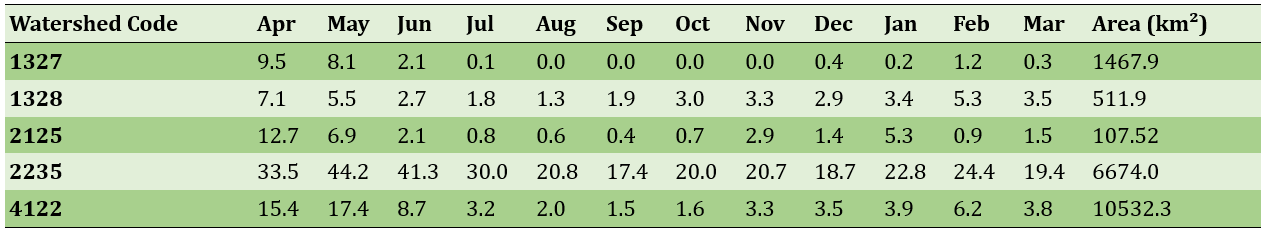
Hamedan Province, located in a humid and semi-humid climate zone, exhibits substantial variability in its hydrological behavior due to topographic and climatic diversity. The region’s watersheds generally showed lower runoff thresholds compared to arid regions, due to reduced rainfall losses and higher soil permeability, leading to consistent base flow throughout the year. Monthly runoff in most rivers flowed throughout the entire year (Table 1).
Table 1. Monthly runoff and watershed areas in Hamedan Province (Cubic meters per second and square kilometers)
The runoff onset threshold had the highest correlation with rainfall depth (Figure 1).
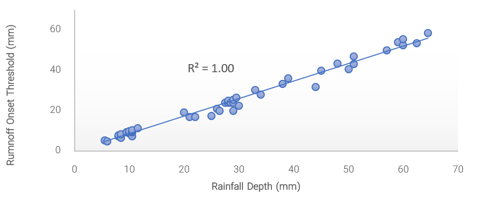
Figure 1. Relationship between rainfall depth and runoff onset threshold
Base flow index (BFI) values ranged from 45.9 to 59.5 across watersheds. Watershed No. 1327 displayed the highest BFI, indicating stable groundwater contributions, while the recession constant (K) values ranged from 1.81 to 3.94, with the highest observed in watershed No. 2235 (Figure 2).
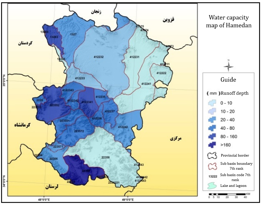
Figure 2. Water capacity map of Hamedan province
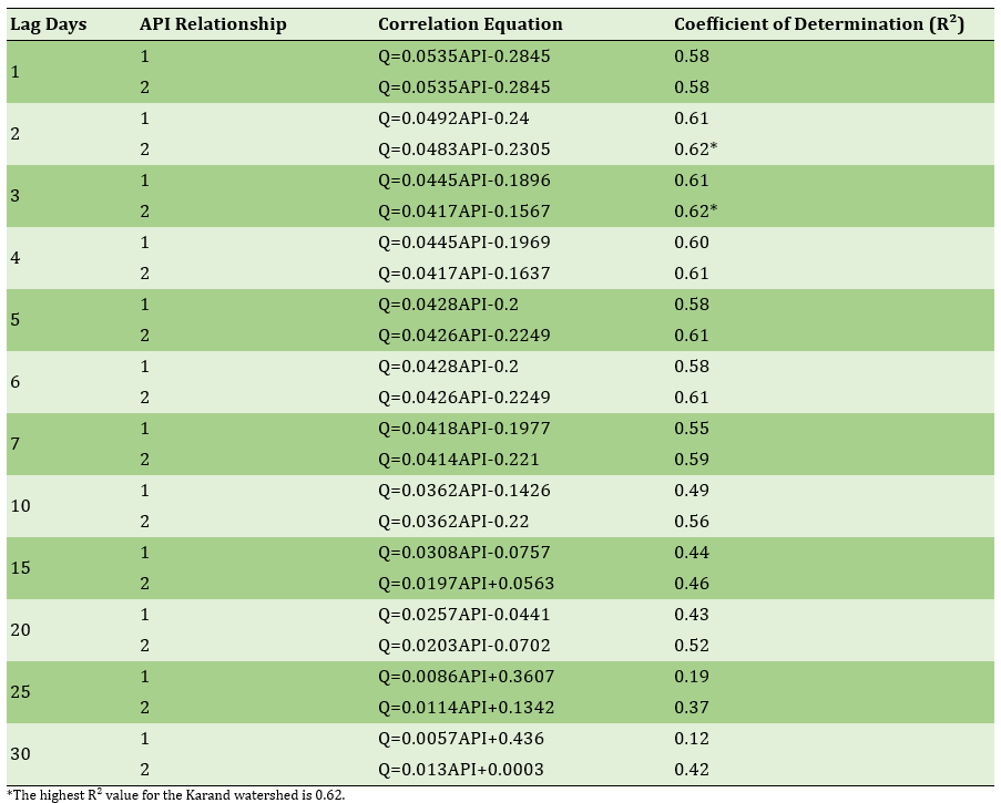
Runoff onset was highly correlated with rainfall depth, followed by runoff depth and rainfall intensity. According to the relationship between antecedent precipitation indices (API) and runoff for different lag days, where the highest R² value (0.62) was observed for a 30-day API.
Table 2. Correlation between Antecedent Precipitation Index (API) and runoff in Karand watershed
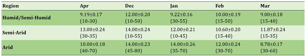
Furthermore, optimized CN values for watersheds were calculated using weighted averages (Table 3).
Table 3) Mean and standard deviation (values in parentheses are minimum and maximum) of the three regions in different months for 1098 basins of the country
The results emphasized the need for tailored watershed management practices to account for diverse hydrological behaviors, optimizing water use and preventing resource depletion.
Main Comparisons to Similar Studies
The findings align with global studies emphasizing the importance of local hydrological characteristics. For example, Smith et al. (2002) identify rainfall depth as a critical determinant of runoff in semi-humid regions, corroborating this study’s results. Similarly, Arnold et al. (2000) highlight the role of watershed attributes in shaping base flow indices, a key focus of this research. However, this study’s integration of spatial and temporal datasets into a unified database offers a novel approach for regional water resource management in Iran.
Suggestions
Effective water resource management is critical in regions prone to natural disasters such as floods and droughts. Accurate knowledge of water capacities, including rainfall, evaporation, transpiration, and runoff parameters, is essential for sustainable development, preventing environmental damage, and aligning supply and demand. However, current data on water capacities are fragmented, hindering efficient decision-making and planning.
Previous Studies
Past research highlights the importance of integrated water resource management for sustainable utilization. Pahl-Wostl (2007) emphasizes adaptive strategies to account for hydrological changes. McMillan et al. (2016) and Gleick (2003) have underscored the need for comprehensive spatial databases integrating diverse hydrological data for better decision-making. In Iran, Alizadeh & Keshavarz (2005) note the critical role of water capacity assessments for urban and agricultural planning. Globally, GIS and remote sensing technologies have proven effective in water resource mapping (Tehrany et al., 2013).
Aim(s)
This study aims to extract and analyze physical parameters, convert point rainfall data into regional datasets, evaluate evaporation and transpiration rates, and develop a spatial database for integrating water capacity maps. These objectives support enhanced decision-making for sustainable watershed management.
Research Type
This is an applied quantitative study focusing on spatial and temporal data analysis to address water resource challenges in Hamedan Province.
Research Society, Place and Time
The study investigated seven-grade watersheds in Hamedan Province, representing a mix of humid and semi-humid climate zones. The research was conducted in Hamedan Province, a mountainous region in western Iran, during 2024. This area features significant elevation variations, influencing precipitation and water dynamics.
Sampling Method and Number
Data collection included geological, physiographic, rainfall, evaporation, and discharge datasets from 12 representative watersheds. These watersheds were chosen to provide a comprehensive understanding of water capacity across the province.
Used Devices & Materials
The study utilized GIS tools for mapping, SPSS 20.0 software for statistical analysis, and AWBM and SFBM hydrological models to simulate water flow and storage dynamics. Data were sourced from hydrometric stations and remote sensing imagery, with precipitation indices calculated using established equations.
Findings by Text
Hamedan Province, located in a humid and semi-humid climate zone, exhibits substantial variability in its hydrological behavior due to topographic and climatic diversity. The region’s watersheds generally showed lower runoff thresholds compared to arid regions, due to reduced rainfall losses and higher soil permeability, leading to consistent base flow throughout the year. Monthly runoff in most rivers flowed throughout the entire year (Table 1).
Table 1. Monthly runoff and watershed areas in Hamedan Province (Cubic meters per second and square kilometers)
The runoff onset threshold had the highest correlation with rainfall depth (Figure 1).
Figure 1. Relationship between rainfall depth and runoff onset threshold
Base flow index (BFI) values ranged from 45.9 to 59.5 across watersheds. Watershed No. 1327 displayed the highest BFI, indicating stable groundwater contributions, while the recession constant (K) values ranged from 1.81 to 3.94, with the highest observed in watershed No. 2235 (Figure 2).
Figure 2. Water capacity map of Hamedan province
Runoff onset was highly correlated with rainfall depth, followed by runoff depth and rainfall intensity. According to the relationship between antecedent precipitation indices (API) and runoff for different lag days, where the highest R² value (0.62) was observed for a 30-day API.
Table 2. Correlation between Antecedent Precipitation Index (API) and runoff in Karand watershed
Furthermore, optimized CN values for watersheds were calculated using weighted averages (Table 3).
Table 3) Mean and standard deviation (values in parentheses are minimum and maximum) of the three regions in different months for 1098 basins of the country
The results emphasized the need for tailored watershed management practices to account for diverse hydrological behaviors, optimizing water use and preventing resource depletion.
Main Comparisons to Similar Studies
The findings align with global studies emphasizing the importance of local hydrological characteristics. For example, Smith et al. (2002) identify rainfall depth as a critical determinant of runoff in semi-humid regions, corroborating this study’s results. Similarly, Arnold et al. (2000) highlight the role of watershed attributes in shaping base flow indices, a key focus of this research. However, this study’s integration of spatial and temporal datasets into a unified database offers a novel approach for regional water resource management in Iran.
Suggestions
- Develop a centralized spatial database to integrate diverse hydrological datasets.
- Implement advanced hydrological models, such as SFBM, for improved runoff predictions.
- Enhance groundwater recharge strategies by leveraging snowline data.
- Establish flood monitoring systems in high-runoff watersheds like No. 2235.
- Promote land-use planning initiatives to optimize water retention.
Conclusion
In humid and semi-humid regions, rainfall depth plays a decisive role in the onset of runoff. Additionally, the analysis of the base flow index and antecedent precipitation index highlights the impact of local watershed characteristics on hydrological patterns. The positive correlation between runoff onset thresholds and rainfall intensity, along with the negative correlation with other parameters such as rainfall depth, clay percentage, and slope, confirms that specific regional features play a significant role in shaping hydrological responses.
Acknowledgments: This article is derived from the "National Project for Preparing and Integrating Maps and Digital Data of Seven-Grade Watersheds in the Country and Developing Related Spatial-Temporal and Thematic Databases for Water Capacity." The authors sincerely thank the Soil Conservation and Watershed Management Research Institute and the responsible project manager for their material and moral support.
Ethical Approval: No ethical concerns were reported by the authors.
Conflict of Interest: The authors declare no conflicts of interest regarding the writing and publication of this article and its findings.
Author Contributions: Behrawan H (First Author), Statistical Analyst, Main Researcher/Discussion Writer (60%); Sharifi F (Second Author), Introduction Writer/Methodologist (40%).
Funding: No financial support was received for this research.
Keywords:
References
1. Akhavan S, Shahverdi M, Zare Abianeh H (2018). Modeling spatial changes of blue water and green water (case study: Hamadan province). Proceedings of the 1st National Conference on Water Resource Management Strategies and Environmental Challenges, Sari. [Persian] [Link]
2. Alizadeh A, Keshavarz A (2005). Status of agricultural water use in Iran. In: Water conservation, reuse, and recycling: Proceedings of an Iranian-American workshop. Washington, D.C.: The National Academies Press. [Link]
3. Arnold JG, Muttiah RS, Srinivasan R, Allen PM (2000). Regional estimation of base flow and groundwater recharge in the Upper Mississippi river basin. Journal of Hydrology. 227(1-4):21-40. [Link] [DOI:10.1016/S0022-1694(99)00139-0]
4. Chiew FHS, Mcmahon TA (2003). El Niño/Southern Oscillation and Australian rainfall and streamflow. Australasian Journal of Water Resources. 6(2):115-129. [Link] [DOI:10.1080/13241583.2003.11465216]
5. Gleick P (2003). Global freshwater resources: Soft-path solutions for the 21st century. Science. 302(5650):1524-1528. [Link] [DOI:10.1126/science.1089967]
6. Hao G, Li J, Song L, Li H, Li Z (2018). Comparison between the TOPMODEL and the Xin'anjiang model and their application to rainfall runoff simulation in semi-humid regions. Environmental Earth Sciences. 77:279. [Link] [DOI:10.1007/s12665-018-7477-4]
7. Helsel DR, Hirsch RM, Ryberg KR, Archfield SA, Gilroy EJ (2002). Statistical methods in water resources. Reston: U.S. Geological Survey. [Link]
8. McMillan H, Montanari A, Cudennec C, Savenije H, Kreibich H, Krueger T, et al (2016). Panta Rhei 2013-2015: Global perspectives on hydrology, society and change. Hydrological Sciences Journal. 61(7):1174-1191. [Link] [DOI:10.1080/02626667.2016.1159308]
9. Mishra SK, Singh VP (2004). Long-term hydrological simulation based on the soil conservation service curve number. Hydrological Processes. 18(7):1291-1313. [Link] [DOI:10.1002/hyp.1344]
10. Mohammadi T, Dastoorani MT (2017). Assessment of basin stability using watershed stability index method. Hydrogeomorphology. 4(10):41-64. [Persian] [Link]
11. Pahl-Wostl C (2007). Transitions towards adaptive management of water facing climate and global change. Water Resources Management. 21(1):49-62. [Link] [DOI:10.1007/s11269-006-9040-4]
12. Rasooli M, Tahmasbi Pour N (2014). Investigation and importance of water resources management in Hamadan province (main basins). Proceedings of the National Conference on Climate Change and Sustainable Agriculture, Hamedan. [Persian] [Link]
13. Sheikh Gudarzi M, Jabarian Amiri B, Azarnivand H (2018). Investigating performance of the conceptual models in river hydrologic simulation. Journal of Natural Environment. 71(4):509-521. [Persian] [Link]
14. Shi P, Yang T, Xu CY, Yong B, Huang CS, Li Z, et al (2019). Rainfall-runoff processes and modelling in regions characterized by deficiency in soil water storage. Water. 11(9):1858. [Link] [DOI:10.3390/w11091858]
15. Simmers I (2003). Understanding water in a dry environment: Hydrological processes in arid and semi-arid zones. Cape Town: A.A. Balkema. [Link] [DOI:10.1201/9780203971307]
16. Smith RE, Smettem K, Broadbridge P, Woolhiser DA (2002). Infiltration theory for hydrologic applications. Washington, D.C.: American Geophysical :union:. [Link] [DOI:10.1029/WM015]
17. Tehrany M, Pradhan B, Jebur M (2013). Spatial prediction of flood susceptible areas using rule based decision tree (DT) and a novel ensemble bivariate and multivariate statistical models in GIS. Journal of Hydrology. 504:69-79. [Link] [DOI:10.1016/j.jhydrol.2013.09.034]
18. Vörösmarty CJ, McIntyre PB, Gessner MO, Dudgeon D, Proussevitch A, Green P, et al (2010). Global threats to human water security and river biodiversity. Nature. 468:334. [Link] [DOI:10.1038/nature09549]
19. Wei W, Jia F, Yang L, Chen L, Zhang H, Yu Y (2014). Effects of surficial condition and rainfall intensity on runoff in a loess hilly area, China. Journal of Hydrology. 513:115-126. [Link] [DOI:10.1016/j.jhydrol.2014.03.022]
20. Wunderle S, Droz M, Kleindienst H (2002). Spatial and temporal analysis of the snow line in the Alps: Based on NOAA-AVHRR data. Geographica Helvetica. 57:170-183. [Link] [DOI:10.5194/gh-57-170-2002]
21. Yari A, Ardalan A, Ostadtaghizadeh A, Zarezadeh Y, Boubakran MS, Bidarpoor F, et al (2019). Underlying factors affecting death due to flood in Iran: A qualitative content analysis. International Journal of Disaster Risk Reduction. 40:101258. [Link] [DOI:10.1016/j.ijdrr.2019.101258]
22. Yazdani V, Behjati E, Arfa A (2015). Flood warning system established by the integrated management of hydrological and hydraulic modeling. Natural Ecosystems of Iran. 5(4):109-122. [Persian] [Link]
23. Zand M, Samai R (2017). Investigation on amount and intensity of rainfalls in flood generation in Khorramabad basin. Nivar. 41(96):1-8. [Persian] [Link]
24. Zhang X, Xu YP, Fu G (2014). Uncertainties in SWAT extreme flow simulation under climate change. Journal of Hydrology. 515:205-222. [Link] [DOI:10.1016/j.jhydrol.2014.04.064]