
Bilingual
En/Fa
Geographical Research is Published in both Persian and English Full-text.
Volume 39, Issue 2 (2024)
GeoRes 2024, 39(2): 139-148 |
Back to browse issues page
Article Type:
Subject:


History
Received: 2023/10/14 | Accepted: 2024/04/22 | Published: 2024/05/25
Received: 2023/10/14 | Accepted: 2024/04/22 | Published: 2024/05/25
How to cite this article
Morsousi N, Nasiri Hendehkhaleh E, Hosseini M. An Integrated Management Model of Spatial Data Infrastructure with a Smart City Approach in District 20 of Tehran. GeoRes 2024; 39 (2) :139-148
URL: http://georesearch.ir/article-1-1538-en.html
URL: http://georesearch.ir/article-1-1538-en.html
Download citation:
BibTeX | RIS | EndNote | Medlars | ProCite | Reference Manager | RefWorks
Send citation to:


Rights and permissions
BibTeX | RIS | EndNote | Medlars | ProCite | Reference Manager | RefWorks
Send citation to:

1- Department of Geography and Urban Planning, Payam-e Noor University, Tehran, Iran
2- Department of Urban Planning, Faculty of Art and Architecture, University of Guilan, Rasht, Iran
2- Department of Urban Planning, Faculty of Art and Architecture, University of Guilan, Rasht, Iran
Full-Text (HTML) (427 Views)
Background
By 2050, most people will live in cities, making smart cities essential. Smart cities rely on spatial data infrastructure (SDI) to provide accurate, timely data for better urban management. Tehran faces challenges due to weak SDI and poor coordination. Building a strong SDI is vital for smart city progress and effective governance.
Previous Studies
Previous studies emphasize the crucial role of spatial data infrastructure (SDI) in smart city development. Anejionu et al. (2019) have proposed an urban spatial data system in the UK using cloud-based big data analytics to support socio-economic urban management. Chaturvedi et al. (2019) highlight the importance of securing SDI for integrating diverse IoT devices and stakeholders in smart cities. Dangermond and Goodchild (2020) call for a new vision for SDI focusing on open access, big data, AI, and web interactions. Alshuwaikhat et al. (2022) emphasize government commitment and investment in advanced technologies as key drivers for smart city sustainability in Saudi Arabia. In Iran, Modarreszadeh Barzoki et al. (2023) identify obstacles to SDI implementation in Tehran and suggested geoportal deployment and improved data management strategies. Habibi and Ghanezadeh (2022) note that SDI could transform urban management by improving access to spatial data. Studies by Monafi and Sarai (2021) and Ghaderi and Sadeghi Arj (2019) stress the importance of integrated SDI for unified urban governance and crisis management.
Aim(s)
The aim of this study is to develop a model for integrated management of spatial data infrastructure with a smart city approach in District 20 of Tehran.
Research Type
This study was of a survey type.
Research Society, Place and Time
The present survey study was conducted in 2023 in Tehran in two qualitative and quantitative phases. The research society included subject-matter experts such as university faculty members specializing in urban development, urban planning, and management, as well as managers and specialists from Tehran’s District 20 municipality, the Spatial Information Department, the Information and Communications Technology Organization of Tehran Municipality (FAVA), and the National Cartographic Center’s Spatial Data Infrastructure Organization.
Sampling Method and Number
16 participants were purposefully selected based on their direct research or practical experience related to the study topic.
Used Devices & Materials
The data collection tools included semi-structured interviews and a questionnaire with 12 questions. In the qualitative phase, key components of integrated spatial data infrastructure management for smart cities were identified and refined based on expert feedback. In the quantitative phase, Structural Equation Modeling (SEM) was used to analyze relationships and test the components. Data analysis, including the formation and processing of Structural Self-Interaction Matrices (SSIM) and reachability matrices, was conducted using Microsoft Excel 2016. Experts involved in the study were selected purposively from academic and municipal staff with relevant experience in urban development, GIS, and spatial data management.
Findings by Text
In the first step of Interpretive Structural Modeling (ISM), by reviewing previous studies and interviewing experts, 12 components related to the integrated management of spatial data infrastructure for the smart city were identified (Table 1). These components were compared by experts using the Structural Self-Interaction Matrix (SSIM), and based on the frequency of opinions, the final matrix was prepared. Then, this matrix was converted into the initial reachability matrix, and after checking internal consistency, the final reachability matrix was extracted, in which 14 corrected entries are marked with *1 (Table 2). The findings showed that the components of “experts’ familiarity and access,” “formulation of policies and standards,” and “existence of geospatial systems” had the greatest influence, while the components of “interaction and cooperation with other data-producing departments” and “cooperation of the municipality with other departments as data users” exhibited the highest dependence.
Table 1. Identified factors influencing the integrated management of spatial data infrastructure in a smart city (as Identified by Experts)
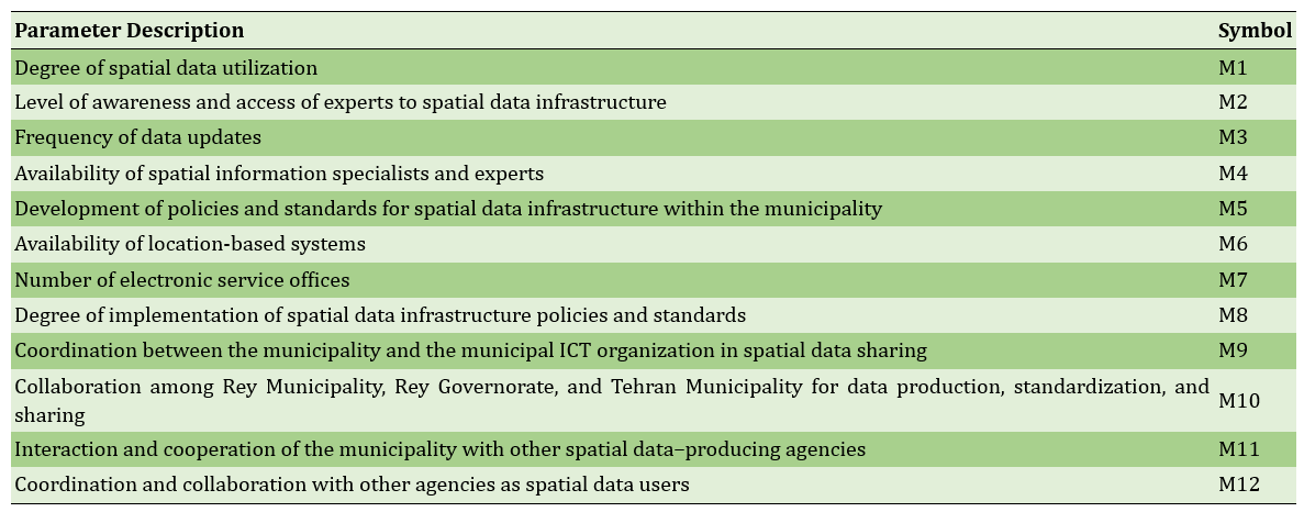
Table 2. Final reachabAility matrix
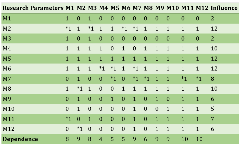
Then, using the final reachability matrix, the components were classified into five levels of the model; the first level included 5 components with the highest dependence, and the fifth level included the component “formulation of SDI policies and standards in the municipality” with the greatest influence. The final research model was presented with these 12 components arranged in five levels.
Main Comparisons to Similar Studies
The present study proposed a model for integrated management of spatial data infrastructure (SDI) with a smart city approach in District 20 of Tehran Municipality. In this model, the "development of policies and standards for spatial data infrastructure" was identified as a key component with the greatest influence and no dependency on other components. This finding aligns with the studies of Modarreszadeh Barzoki et al. (2023) and Pourahmad et al. (2018), which emphasize the importance of unified policy and standards development in smart governance to reduce costs and redundancies. The presence of specialized personnel as an executive factor at the fourth level and its critical role in the success of spatial data management is also consistent with the findings of Modarreszadeh Barzoki et al. (2016) and Monafi and Sarai (2021). Moreover, interaction and coordination between the municipality and other data-producing entities which was confirmed by Modarreszadeh Barzoki et al. (2023), Monafi and Sarai (2021), and Modarreszadeh et al. (2016) are vital for developing the spatial data infrastructure. These collaborations facilitate the creation of standardized databases and data sharing, thereby supporting smart urban management and enhancing efficiency. Additionally, the importance of coordination between the municipality and higher-level institutions, as well as inter-organizational cooperation, is supported by the findings of Mehrnezhad and Shahbinezhad (2013).
Suggestions
It is essential that data infrastructure follows approved international and national standards with strict supervision in the municipality. Coordination among departments is needed to build proper data systems. The role of managers and decision-makers in District 20 municipality is vital, especially in creating and enforcing policies and standardizing spatial data processes.
Conclusion
The existence of defined policies and standards for spatial data infrastructure has the greatest impact on other components. Therefore, developing these policies and standards can create a systematic framework that supports the implementation of other smart spatial data management elements, including data collection, organization, sharing, and effective use.
Acknowledgments: The authors sincerely thank the managers , teachers and specialists for responding to the questionnaire .
Ethical Permission: None reported by the authors.
Conflict of Interest: None reported by the authors.
Authors’ Contributions: Marsousi N (First author), Introduction Writer/Discussion Writer (30%); Nasiri Hendehkhaleh E (Second author), Introduction Writer/Discussion Writer (30%); Hosseini MR (Third author), Introduction Writer/Discussion Writer Methodologist (40%).
Funding: None reported by the authors.
By 2050, most people will live in cities, making smart cities essential. Smart cities rely on spatial data infrastructure (SDI) to provide accurate, timely data for better urban management. Tehran faces challenges due to weak SDI and poor coordination. Building a strong SDI is vital for smart city progress and effective governance.
Previous Studies
Previous studies emphasize the crucial role of spatial data infrastructure (SDI) in smart city development. Anejionu et al. (2019) have proposed an urban spatial data system in the UK using cloud-based big data analytics to support socio-economic urban management. Chaturvedi et al. (2019) highlight the importance of securing SDI for integrating diverse IoT devices and stakeholders in smart cities. Dangermond and Goodchild (2020) call for a new vision for SDI focusing on open access, big data, AI, and web interactions. Alshuwaikhat et al. (2022) emphasize government commitment and investment in advanced technologies as key drivers for smart city sustainability in Saudi Arabia. In Iran, Modarreszadeh Barzoki et al. (2023) identify obstacles to SDI implementation in Tehran and suggested geoportal deployment and improved data management strategies. Habibi and Ghanezadeh (2022) note that SDI could transform urban management by improving access to spatial data. Studies by Monafi and Sarai (2021) and Ghaderi and Sadeghi Arj (2019) stress the importance of integrated SDI for unified urban governance and crisis management.
Aim(s)
The aim of this study is to develop a model for integrated management of spatial data infrastructure with a smart city approach in District 20 of Tehran.
Research Type
This study was of a survey type.
Research Society, Place and Time
The present survey study was conducted in 2023 in Tehran in two qualitative and quantitative phases. The research society included subject-matter experts such as university faculty members specializing in urban development, urban planning, and management, as well as managers and specialists from Tehran’s District 20 municipality, the Spatial Information Department, the Information and Communications Technology Organization of Tehran Municipality (FAVA), and the National Cartographic Center’s Spatial Data Infrastructure Organization.
Sampling Method and Number
16 participants were purposefully selected based on their direct research or practical experience related to the study topic.
Used Devices & Materials
The data collection tools included semi-structured interviews and a questionnaire with 12 questions. In the qualitative phase, key components of integrated spatial data infrastructure management for smart cities were identified and refined based on expert feedback. In the quantitative phase, Structural Equation Modeling (SEM) was used to analyze relationships and test the components. Data analysis, including the formation and processing of Structural Self-Interaction Matrices (SSIM) and reachability matrices, was conducted using Microsoft Excel 2016. Experts involved in the study were selected purposively from academic and municipal staff with relevant experience in urban development, GIS, and spatial data management.
Findings by Text
In the first step of Interpretive Structural Modeling (ISM), by reviewing previous studies and interviewing experts, 12 components related to the integrated management of spatial data infrastructure for the smart city were identified (Table 1). These components were compared by experts using the Structural Self-Interaction Matrix (SSIM), and based on the frequency of opinions, the final matrix was prepared. Then, this matrix was converted into the initial reachability matrix, and after checking internal consistency, the final reachability matrix was extracted, in which 14 corrected entries are marked with *1 (Table 2). The findings showed that the components of “experts’ familiarity and access,” “formulation of policies and standards,” and “existence of geospatial systems” had the greatest influence, while the components of “interaction and cooperation with other data-producing departments” and “cooperation of the municipality with other departments as data users” exhibited the highest dependence.
Table 1. Identified factors influencing the integrated management of spatial data infrastructure in a smart city (as Identified by Experts)
Table 2. Final reachabAility matrix
Then, using the final reachability matrix, the components were classified into five levels of the model; the first level included 5 components with the highest dependence, and the fifth level included the component “formulation of SDI policies and standards in the municipality” with the greatest influence. The final research model was presented with these 12 components arranged in five levels.
Main Comparisons to Similar Studies
The present study proposed a model for integrated management of spatial data infrastructure (SDI) with a smart city approach in District 20 of Tehran Municipality. In this model, the "development of policies and standards for spatial data infrastructure" was identified as a key component with the greatest influence and no dependency on other components. This finding aligns with the studies of Modarreszadeh Barzoki et al. (2023) and Pourahmad et al. (2018), which emphasize the importance of unified policy and standards development in smart governance to reduce costs and redundancies. The presence of specialized personnel as an executive factor at the fourth level and its critical role in the success of spatial data management is also consistent with the findings of Modarreszadeh Barzoki et al. (2016) and Monafi and Sarai (2021). Moreover, interaction and coordination between the municipality and other data-producing entities which was confirmed by Modarreszadeh Barzoki et al. (2023), Monafi and Sarai (2021), and Modarreszadeh et al. (2016) are vital for developing the spatial data infrastructure. These collaborations facilitate the creation of standardized databases and data sharing, thereby supporting smart urban management and enhancing efficiency. Additionally, the importance of coordination between the municipality and higher-level institutions, as well as inter-organizational cooperation, is supported by the findings of Mehrnezhad and Shahbinezhad (2013).
Suggestions
It is essential that data infrastructure follows approved international and national standards with strict supervision in the municipality. Coordination among departments is needed to build proper data systems. The role of managers and decision-makers in District 20 municipality is vital, especially in creating and enforcing policies and standardizing spatial data processes.
Conclusion
The existence of defined policies and standards for spatial data infrastructure has the greatest impact on other components. Therefore, developing these policies and standards can create a systematic framework that supports the implementation of other smart spatial data management elements, including data collection, organization, sharing, and effective use.
Acknowledgments: The authors sincerely thank the managers , teachers and specialists for responding to the questionnaire .
Ethical Permission: None reported by the authors.
Conflict of Interest: None reported by the authors.
Authors’ Contributions: Marsousi N (First author), Introduction Writer/Discussion Writer (30%); Nasiri Hendehkhaleh E (Second author), Introduction Writer/Discussion Writer (30%); Hosseini MR (Third author), Introduction Writer/Discussion Writer Methodologist (40%).
Funding: None reported by the authors.
References
1. Ahmad T, Zhang D (2021). Using the internet of things in smart energy systems and networks. Sustainable Cities and Society. 68:102783. [Link] [DOI:10.1016/j.scs.2021.102783]
2. Alshuwaikhat HM, Aina YA, Binsaedan L (2022). Analysis of the implementation of urban computing in smart cities: A framework for the transformation of Saudi cities. Heliyon. 8(10):e11138. [Link] [DOI:10.1016/j.heliyon.2022.e11138]
3. Anejionu OCD, Thakuriah P, McHugh A, Sun Y, McArthur D, Mason P, et al (2019). Spatial urban data system: A cloud-enabled big data infrastructure for social and economic urban analytics. Future Generation Computer Systems. 98:456-473. [Link] [DOI:10.1016/j.future.2019.03.052]
4. Chaturvedi K, Matheus A, Nguyen SH, Kolbe TH (2019). Securing spatial data infrastructures for distributed smart city applications and services. Future Generation Computer Systems. 101:723-736. [Link] [DOI:10.1016/j.future.2019.07.002]
5. Cheng C, Dou J, Zheng Z (2022). Energy-efficient SDN for Internet of Things in smart city. Internet of Things and Cyber-Physical Systems. 2:145-158. [Link] [DOI:10.1016/j.iotcps.2022.07.003]
6. Dangermond J, Goodchild MF (2020). Building geospatial infrastructure. Geo-Spatial Information Science. 23(1):1-9. [Link] [DOI:10.1080/10095020.2019.1698274]
7. Daryabeigi Zand A, Vaezi Heir A (2020). Emerging challenges in urban waste management in Tehran, Iran during the COVID-19 pandemic. Resources, Conservation and Recycling. 162:105051. [Link] [DOI:10.1016/j.resconrec.2020.105051]
8. Ghaderi M, Sadeghi Arj M (2019). Explaining a solution to achieve integrated urban management by using spatial information infrastructure (SDI) (emphasizing the importance of the issue in the urban management structure of Iran). Proceedings of the 2nd International Conference on Civil Engineering, Architecture and Urban Development Management in Iran. Tehran: University of Tehran. [Persian] [Link]
9. Habibi K, Ghanezadeh SM (2022). Pathology of integrated urban management with emphasis on the role of spatial data infrastructure The case study Sanandaj city. Geographical Urban Planning Research. 10(1):207-226. [Persian] [Link]
10. Hajduk S (2016). The concept of a smart city in urban management. Business, Management and Economics Engineering. 14(1):34-49. [Link] [DOI:10.3846/bme.2016.319]
11. Hu Y, Li W (2017). Spatial data infrastructures. The Geographic Information Science & Technology Body of Knowledge. [Link] [DOI:10.22224/gistbok/2017.2.1]
12. Hussein NH, Yaw CT, Koh SP, Tiong SK, Chong KH (2022). A comprehensive survey on vehicular networking: Communications, applications, challenges, and upcoming research directions. IEEE Access. 10:86127-86180. [Link] [DOI:10.1109/ACCESS.2022.3198656]
13. Kirimtat A, Krejcar O, Kertesz A, Tasgetiren MF (2020). Future trends and current state of smart city concepts: A survey. IEEE Access. 8:86448-86467. [Link] [DOI:10.1109/ACCESS.2020.2992441]
14. Laufs J, Borrion H, Bradford B (2020). Security and the smart city: A systematic review. Sustainable Cities and Society. 55:102023. [Link] [DOI:10.1016/j.scs.2020.102023]
15. Mahdizadeh M (2019). Investigating the relationship between the smart city and sustainable development and the challenges of achieving a sustainable smart city. Shabak. 5(7):119-128. [Persian] [Link]
16. Mattingly M (1995). Urban management in less developed countries. London: The Bartlett Development Planning Unit. Working Paper. No 72. [Link]
17. Mehrnezhad P, Shahbi Nezhad S (2013). Integrated management of urban development based on spatial data infrastructure (SDI). Proceedings of the First National Conference on Urban Development Over Time. Qazvin: Imam Khomeini International University. [Persian] [Link]
18. Modareszadeh Barzoki A, Banaie V, Mesgari MS, Sarvar R (2016). Explaining the spatial data infrastructure (SDI) approach in the information management of urban facilities in Tehran. National Geomatics Conference. [Persian] [Link]
19. Modarreszadeh Barzoki A, Sarvar R, Asadian F (2023). Pathology of the fulfillment of SDI establishment requirements and its strategies in Tehran Metropolitan Peri-Urban. Journal of Program and Development Research. 4(2):7-34. [Persian] [Link]
20. Monafi S, Sarai MH (2021). Assess integrated crisis management with a spatial data infrastructure approach. Urban Economics & Planning. 2(1):10-18. [Persian] [Link]
21. Mu R, Haershan M, Wu P (2022). What organizational conditions, in combination, drive technology enactment in government-led smart city projects?. Technological Forecasting and Social Change. 174:121220. [Link] [DOI:10.1016/j.techfore.2021.121220]
22. Pourahmad A, Ziyari K, Hataminejad H, Parsa S (2018). Smart city: Explaining the needs and requirements of Tehran city for smartness. New Perspectives in Human Geography (Human Geography). 10(2):1-22. [Persian] [Link]
23. Powner DA, Phillips C, Businsky CG, Epperson KL, Eyler R, Mingus J, et al (2015). Geospatial data: Progress needed on identifying expenditures, building and utilizing a data infrastructure, and reducing duplicative efforts. Washington, DC: U.S. Government Accountability Office. [Link]
24. Rieke M, Bigagli L, Herle S, Jirka S, Kotsev A, Liebig T, et al (2018). Geospatial IoT-The need for event-driven architectures in contemporary spatial data infrastructures. ISPRS International Journal of Geo-Information. 7(10):385. [Link] [DOI:10.3390/ijgi7100385]
25. Rui Y, Ban Y (2011). Urban growth modeling with road network expansion and land use development. In: Advances in cartography and GIScience. Heidelberg: Springer. 2:399-412. [Link] [DOI:10.1007/978-3-642-19214-2_27]
26. Schade S, Granell C, Vancauwenberghe G, Keßler C, Vandenbroucke D, Masser I, et al (2020). Geospatial information infrastructures. In: Guo H, Goodchild MF, Annoni A, editors. Manual of Digital Earth. Heidelberg: Springer. p. 161-190. [Link] [DOI:10.1007/978-981-32-9915-3_5]
27. Simões P, Neto MC, Sarmento P, Barriguinha A (2023). Oeste smart region. Mapping. 32(211):50-61. [Link] [DOI:10.59192/mapping.395]
28. Statistical Center of Iran (2023). Statistical yearbook of Tehran province. Tehran: Statistical Information System of Tehran Province. [Persain] [Link]
29. Zanella A, Bui N, Castellani A, Vangelista L, Zorzi M (2014). Internet of things for smart cities. IEEE Internet of Things Journal. 1(1):22-32. [Link] [DOI:10.1109/JIOT.2014.2306328]