
Bilingual
En/Fa
Geographical Research is Published in both Persian and English Full-text.
Volume 39, Issue 2 (2024)
GeoRes 2024, 39(2): 117-127 |
Back to browse issues page
Article Type:
Subject:


History
Received: 2024/01/14 | Accepted: 2024/03/14 | Published: 2024/06/5
Received: 2024/01/14 | Accepted: 2024/03/14 | Published: 2024/06/5
How to cite this article
Mobasheri M, Miri G, Sharifinia Z. Strategies for Mitigating Vulnerability of Critical Urban Arteries to Flooding within Bojnurd City. GeoRes 2024; 39 (2) :117-127
URL: http://georesearch.ir/article-1-1573-en.html
URL: http://georesearch.ir/article-1-1573-en.html
Download citation:
BibTeX | RIS | EndNote | Medlars | ProCite | Reference Manager | RefWorks
Send citation to:


Rights and permissions
BibTeX | RIS | EndNote | Medlars | ProCite | Reference Manager | RefWorks
Send citation to:

1- Department of Geography and Urban Planning, Zahedan Branch, Islamic Azad University, Zahedan, Iran
2- Department of Geography and Tourism Planning, Sari Branch, Islamic Azad University, Sari, Iran
2- Department of Geography and Tourism Planning, Sari Branch, Islamic Azad University, Sari, Iran
Full-Text (HTML) (594 Views)
Background
Natural hazards, in their various forms and extents, have always posed a significant threat to human life and property. These hazards are recurring and destructive phenomena that can lead to substantial loss of life and economic damage. They result in long-term and sometimes irreversible consequences for affected communities. Natural hazards often cause environmental changes that disrupt normal life and impact settlements, leading to widespread economic, social, and environmental damage [Poortaheri, 2010; Blaikie et al., 2010]. In particular, floods, which are among the most devastating natural hazards, have become a growing threat to rural development and well-being. Floods are associated with geomorphological, hydrological, and atmospheric processes [Bostani & Javani, 2013].
Previous Studies
Various studies have highlighted the significant impact of floods. For instance, Poortaheri et al. [2014] note that natural hazards increasingly threaten rural communities. Studies such as those by Sowmya et al. [2015] and Abedini & Khoshkhovi Delshad [2016] identified key factors affecting flood vulnerability, such as slope, permeability, and erosion. Cheraghi Ghalehsari et al. [2020] found that support vector machines effectively identify flood-prone areas. Omidvarfar et al. [2021] and Fleischmann et al. [2021] demonstrated the impact of various environmental parameters on flood risk in different regions. Ahmad et al. [2022] and Mabrouk et al. [2024] emphasized the utility of advanced neural networks and urban planning strategies to manage flood risks. Other studies, such as those by Sanaifard et al. [2023] and Wang et al. [2024], focused on the alignment of flood control infrastructure and the role of vegetation in flood resilience.
Aim(s)
The primary aim of this study was to identify the pathways of surface water entry into the city, assess the vulnerability of the city to flooding using Random Forest (RF) models, and identify critical infrastructures vulnerable to flooding.
Research Type
This study was applied research focusing on flood vulnerability assessment and infrastructure analysis using computational models.
Research Society
The study focused on the city of Bojnurd in North Khorasan Province, Iran.
Place and Time
The research was conducted in Bojnurd, a city with an area of 100 square kilometers in North Khorasan Province, Iran, during 2023-2024 (Figure 1).
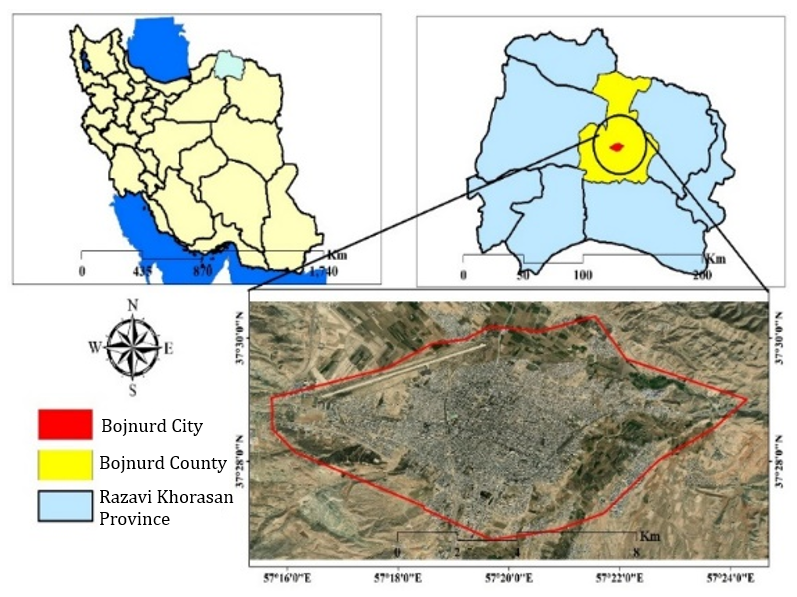
Figure 1. studied area
Sampling Method and Number
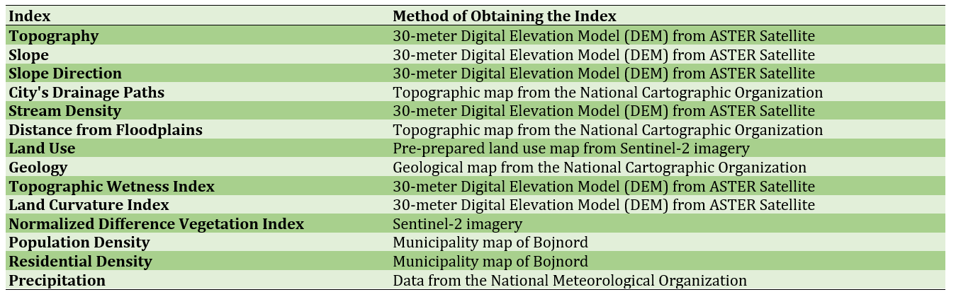
Data was collected through library and documentary research. Fourteen indicators were used to assess flood vulnerability. Additionally, 200 high-resolution satellite images and field observation data were used to develop the RF model, with data equally divided between flood-prone and non-flood-prone areas.
Used Devices & Materials
The study utilized various data sources including:
Findings by Text
The analysis revealed that the elevation, precipitation, and land use were the most influential factors in flood vulnerability (Figure 2). High-risk areas were found in the southern and central parts of Bojnurd, where elevations are lower and vegetation is sparse (Figure 3). The RF model's output indicated high-risk zones, with approximately 13.73% of the area at highest risk and 50% of residential areas in high-risk zones (Figure 4).
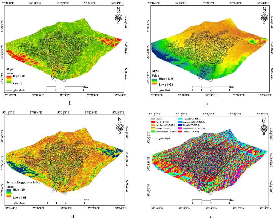
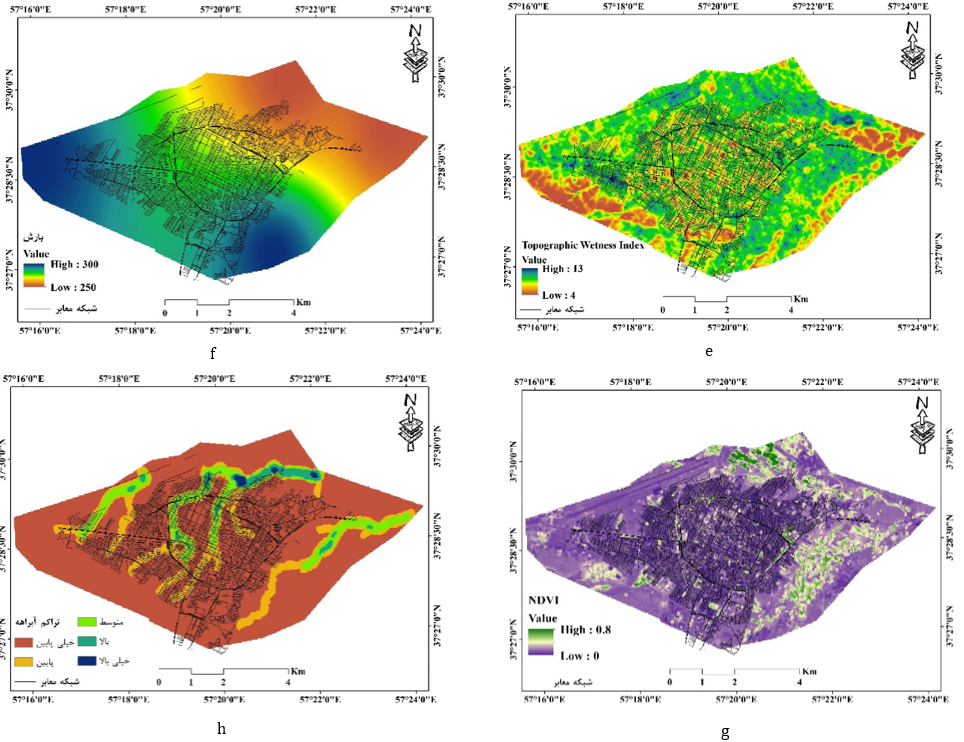
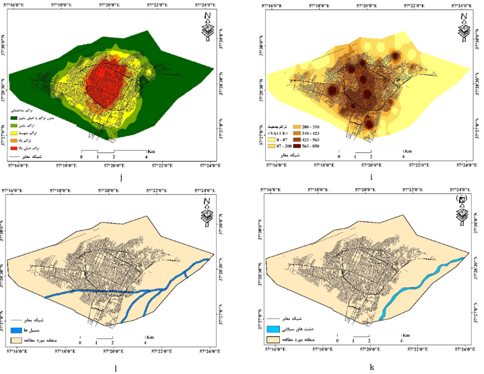
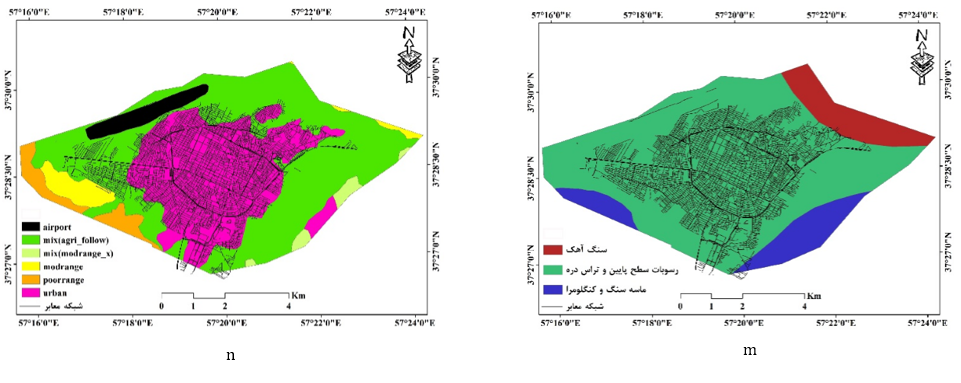
Figure 2. Factors Influencing Flooding (a: Elevation Classes; b: Slope; c: Direction; d: Land Curvature; e: Topographic Wetness; f: Precipitation; g: Vegetation Cover; h: Stream Density; i: Population Density; j: Residential Density; k: Floodplains; l: Drainage Path Wetness; m: Geology; n: Land Use)
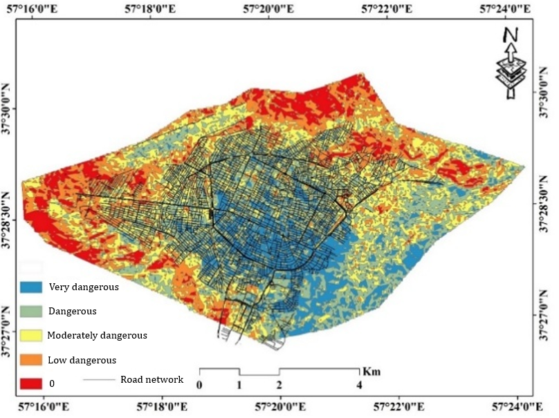
Figure 3. Flood hazard map
Figure 4. high to low risk lands proportion
Most of the region's area, particularly residential areas, was at risk of flooding, with critical infrastructure, especially in the southern areas, also at flood risk, while some were in no-risk or medium-risk zones (Figure 5).
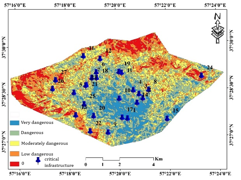
Figure 5. The map of flood risk in critical infrastructure
Main Comparisons to Similar Studies
This study aligns with findings from previous research, which also identified elevation and precipitation as critical factors in flood risk assessment [Sowmya et al., 2015; Abedini & Khoshkhovi Delshad, 2016]. The use of RF models for flood risk mapping is consistent with the successful application of similar techniques in other regions [Cheraghi Ghalehsari et al., 2020; Ahmad et al., 2022].
Suggestions
Based on the findings, it is suggested that Bojnurd should enhance flood resilience by:
Elevation, precipitation, and land use have a significant impact on flood occurrence in the city of Bojnord. Most areas with residential land use are at high risk of flooding.
Acknowledgments: Nothing is declared by the authors.
Ethical Permission: Nothing is declared by the authors.
Conflict of Interest: Nothing is declared by the authors.
Authors' Contributions: Mahdi Mobasheri (first author), Methodologist/Discussion Writer/Statistical Analyst (35%); Gholamreza Miri (second author), Introduction Writer/Discussion Writer/Methodologist (35%); Zahra Sharifinia (third author), Discussion Writer/Statistical Analyst (30%).
Funding: This research was conducted using personal funds.
Natural hazards, in their various forms and extents, have always posed a significant threat to human life and property. These hazards are recurring and destructive phenomena that can lead to substantial loss of life and economic damage. They result in long-term and sometimes irreversible consequences for affected communities. Natural hazards often cause environmental changes that disrupt normal life and impact settlements, leading to widespread economic, social, and environmental damage [Poortaheri, 2010; Blaikie et al., 2010]. In particular, floods, which are among the most devastating natural hazards, have become a growing threat to rural development and well-being. Floods are associated with geomorphological, hydrological, and atmospheric processes [Bostani & Javani, 2013].
Previous Studies
Various studies have highlighted the significant impact of floods. For instance, Poortaheri et al. [2014] note that natural hazards increasingly threaten rural communities. Studies such as those by Sowmya et al. [2015] and Abedini & Khoshkhovi Delshad [2016] identified key factors affecting flood vulnerability, such as slope, permeability, and erosion. Cheraghi Ghalehsari et al. [2020] found that support vector machines effectively identify flood-prone areas. Omidvarfar et al. [2021] and Fleischmann et al. [2021] demonstrated the impact of various environmental parameters on flood risk in different regions. Ahmad et al. [2022] and Mabrouk et al. [2024] emphasized the utility of advanced neural networks and urban planning strategies to manage flood risks. Other studies, such as those by Sanaifard et al. [2023] and Wang et al. [2024], focused on the alignment of flood control infrastructure and the role of vegetation in flood resilience.
Aim(s)
The primary aim of this study was to identify the pathways of surface water entry into the city, assess the vulnerability of the city to flooding using Random Forest (RF) models, and identify critical infrastructures vulnerable to flooding.
Research Type
This study was applied research focusing on flood vulnerability assessment and infrastructure analysis using computational models.
Research Society
The study focused on the city of Bojnurd in North Khorasan Province, Iran.
Place and Time
The research was conducted in Bojnurd, a city with an area of 100 square kilometers in North Khorasan Province, Iran, during 2023-2024 (Figure 1).
Figure 1. studied area
Sampling Method and Number
Data was collected through library and documentary research. Fourteen indicators were used to assess flood vulnerability. Additionally, 200 high-resolution satellite images and field observation data were used to develop the RF model, with data equally divided between flood-prone and non-flood-prone areas.
Used Devices & Materials
The study utilized various data sources including:
Findings by Text
The analysis revealed that the elevation, precipitation, and land use were the most influential factors in flood vulnerability (Figure 2). High-risk areas were found in the southern and central parts of Bojnurd, where elevations are lower and vegetation is sparse (Figure 3). The RF model's output indicated high-risk zones, with approximately 13.73% of the area at highest risk and 50% of residential areas in high-risk zones (Figure 4).
Figure 2. Factors Influencing Flooding (a: Elevation Classes; b: Slope; c: Direction; d: Land Curvature; e: Topographic Wetness; f: Precipitation; g: Vegetation Cover; h: Stream Density; i: Population Density; j: Residential Density; k: Floodplains; l: Drainage Path Wetness; m: Geology; n: Land Use)
Figure 3. Flood hazard map
Figure 4. high to low risk lands proportion
Most of the region's area, particularly residential areas, was at risk of flooding, with critical infrastructure, especially in the southern areas, also at flood risk, while some were in no-risk or medium-risk zones (Figure 5).
Figure 5. The map of flood risk in critical infrastructure
Main Comparisons to Similar Studies
This study aligns with findings from previous research, which also identified elevation and precipitation as critical factors in flood risk assessment [Sowmya et al., 2015; Abedini & Khoshkhovi Delshad, 2016]. The use of RF models for flood risk mapping is consistent with the successful application of similar techniques in other regions [Cheraghi Ghalehsari et al., 2020; Ahmad et al., 2022].
Suggestions
Based on the findings, it is suggested that Bojnurd should enhance flood resilience by:
- Improving flood management infrastructure in high-risk areas.
- Implementing better land use planning and vegetation strategies.
- Regularly updating flood risk maps using advanced modeling techniques.
Elevation, precipitation, and land use have a significant impact on flood occurrence in the city of Bojnord. Most areas with residential land use are at high risk of flooding.
Acknowledgments: Nothing is declared by the authors.
Ethical Permission: Nothing is declared by the authors.
Conflict of Interest: Nothing is declared by the authors.
Authors' Contributions: Mahdi Mobasheri (first author), Methodologist/Discussion Writer/Statistical Analyst (35%); Gholamreza Miri (second author), Introduction Writer/Discussion Writer/Methodologist (35%); Zahra Sharifinia (third author), Discussion Writer/Statistical Analyst (30%).
Funding: This research was conducted using personal funds.
Keywords:
References
1. Abedini M, Khoshkhovi Delshad A (2016). Investigating the factors affecting the occurrence of floods in the Hawaiq basin using the ANP model. Proceedings of the 1st International Conference on Iranian Natural Hazards and Environmental Crises, Strategies and Challenges. Ardabil: University of Mohaghegh Ardabili. [Persian] [Link]
2. Ahmed N, Hoque MAA, Arabameri A, Pal SC, Chakrabortty R, Jui J (2022). Flood susceptibility mapping in Brahmaputra floodplain of Bangladesh using deep boost, deep learning neural network, and artificial neural network. Geocarto International. 37(25):8770-8791. [Link] [DOI:10.1080/10106049.2021.2005698]
3. Blaikie P, Cannon T, Davis I, Wisner B (2010). At risk: Natural hazards, people's vulnerability and disasters. 2nd edition. London: Routledge. [Link]
4. Bostani A, Javani Kh (2013). Investigation and recognition of natural hazards (earthquake and flood) and its effects on the vulnerability of villages (case study of villages in Darab city). Proceedings of the second International Conference on Environmental Hazards. Tehran: Kharazmi University. [Persian] [Link]
5. Chen W, Zhai G, Fan C, Jin W, Xie Y (2017). A planning framework based on system theory and GIS for urban emergency shelter system: A case of Guangzhou, China. Human and Ecological Risk Assessment: An International Journal. 23(3):441-456. [Link] [DOI:10.1080/10807039.2016.1185692]
6. Cheraghi Ghalehsari A, Habibnejad Roshan M, Roshun SH (2020). Flood susceptibility mapping using a Support Vector Machine models (SVM) and Geographic Information System (GIS). Journal of Natural Environment Hazards. 9(25):61-80. [Persian] [Link]
7. Fleischmann AS, Fialho Brêda JP, Rudorff C, Dias de Paiva RC, Collischonn W, Papa F, et al (2021). River flood modeling and remote sensing across scales: Lessons from Brazil. In: Schumann GJP, editor. Earth observation for flood applications: Progress and perspectives. Amsterdam: Elsevier. p. 61-103. [Link] [DOI:10.1016/B978-0-12-819412-6.00004-3]
8. Ghobadi F, Khodashenas SR, Mosaedi A (2019). Comparison of uniform rainfall method and alternative block method in estimating runoff collecting system in order to control flood in urban areas with ASSA software (case study: Chehel Bazeh Golestan Basin). Iranian Journal of Irrigation and Drainage. 13(5):1491-1503. [Persian] [Link]
9. Hosseini FS, Choubin B, Mosavi A, Nabipour N, Shamshirband S, Darabi H, et al (2020). Flash-flood hazard assessment using ensembles and Bayesian-based machine learning models: Application of the simulated annealing feature selection method. Science of the Total Environment. 711:135161. [Link] [DOI:10.1016/j.scitotenv.2019.135161]
10. Lee S, Kim JC, Jung HS, Lee MJ, Lee S (2017). Spatial prediction of flood susceptibility using random-forest and boosted-tree models in Seoul metropolitan city, Korea. Geomatics, Natural Hazards and Risk. 8(2):1185-1203. [Link] [DOI:10.1080/19475705.2017.1308971]
11. Leta BM, Adugna D, Wondim AA (2024). Comprehensive investigation of flood-resilient neighborhoods: The case of Adama City, Ethiopia. Applied Water Science. 14(2):14. [Link] [DOI:10.1007/s13201-023-02053-7]
12. Mabrouk M, Han H, Abdrabo KI, Mahran MGN, AbouKorin SAA, Nasrallah S, et al (2024). Spatial congruency or discrepancy? Exploring the spatiotemporal dynamics of built-up expansion patterns and flood risk. Science of the Total Environment. 915:170019. [Link] [DOI:10.1016/j.scitotenv.2024.170019]
13. Omidvarfar S, Hosseini L, Fakhari Z, Ghanbari S (2021). Zoning and flood risk assessment in Tabriz city using Fuzzy AHP model. Proceedings of the 2nd International Conference and 5th National Conference on Natural Resources and Environment. Ardabil: University of Mohaghegh Ardabili. [Persian] [Link]
14. Pahlavan Rad MR, Toomanian N, Khormali F, Brungard CW, Komaki CB, Bogaert P (2014). Updating soil survey maps using random forest and conditioned Latin hypercube sampling in the loess derived soils of northern Iran. Geoderma. 232-234:97-106. [Link] [DOI:10.1016/j.geoderma.2014.04.036]
15. Poortaheri M (2010). Application of multi attribute decision making methods in geography. 1st edition. Tehran: SAMT Publications. [Persian] [Link]
16. Poortaheri M, Hajinejad A, Fatahi A, Nemati R (2014) Physical vulnerability assessment of rural habitats against natural hazards (earthquakes) with a decision model (KOPRS) (case study Chalan Cholan villages, Dorud Township). The Journal of Spatial Planning. 18(3):29-52. [Persian] [Link]
17. Saffari A, Ahmadabadi A, Sedighifar Z (2020). Flood risk analysis based on the WMS model in urban catchments (case study: Damand basins, Golabdareh and Saadabad, Tehran metropolitan area). Journal of Applied Research in Geographical Sciences. 20(57):317-334. [Persian] [Link] [DOI:10.29252/jgs.20.57.317]
18. Salvo G, Karakikes I, Papaioannou G, Polydoropoulou A, Sanfilippo L, Brignone A (2024). Enhancing urban resilience: Managing flood-induced disruptions in road networks. [Link] [DOI:10.21203/rs.3.rs-3908598/v1]
19. Sanaifard A, Amirahmadi A, Zanganeh Y (2023). Reducing the vulnerability of vital arteries to flood (case study: Sabzevar County). Research and Urban Planning. 14(52):1-16. [Persian] [Link]
20. Sowmya K, John CM, Shrivasthava NK (2015). Urban flood vulnerability zoning of Cochin City, southwest coast of India, using remote sensing and GIS. Natural Hazards. 75(2):1271-1286. [Link] [DOI:10.1007/s11069-014-1372-4]
21. Statistical Yearbook of Bojnurd Governorate (2022). Bojnurd: North Khorasan Standard General Administration. [Persian] [Link]
22. Taherkhani M, Sojasi Qeydari H, Sadeghloo T (2012). Comparative assessment of ranking methods for natural disasters in rural regions (case study: Zanjan Province). Journal of Rural Research. 2(7):31-54. [Persian] [Link]
23. Tehrany MS, Jones S, Shabani F (2019). Identifying the essential flood conditioning factors for flood prone area mapping using machine learning techniques. CATENA. 175:174-192. [Link] [DOI:10.1016/j.catena.2018.12.011]
24. UNDRR (2015). The human cost of weather-related disasters 1995-2015. Geneva: United Nations Office for Disaster Risk Reduction. [Link]
25. Wang Z, Li Z, Wang Y, Zheng X, Deng X (2024). Building green infrastructure for mitigating urban flood risk in Beijing, China. Urban Forestry & Urban Greening. 93:128218. [Link] [DOI:10.1016/j.ufug.2024.128218]