
Bilingual
En/Fa
Geographical Research is Published in both Persian and English Full-text.
Volume 37, Issue 2 (2022)
GeoRes 2022, 37(2): 189-199 |
Back to browse issues page
Article Type:
Subject:


History
Received: 2021/12/18 | Accepted: 2022/02/24 | Published: 2022/04/8
Received: 2021/12/18 | Accepted: 2022/02/24 | Published: 2022/04/8
How to cite this article
Houshyar H, Ramazantash Dehgorje H. The Status QUO Analysis of the Buildings Vulnerability in the City of Oshnavieh to Earthquake. GeoRes 2022; 37 (2) :189-199
URL: http://georesearch.ir/article-1-1274-en.html
URL: http://georesearch.ir/article-1-1274-en.html
Download citation:
BibTeX | RIS | EndNote | Medlars | ProCite | Reference Manager | RefWorks
Send citation to:


Rights and permissions
BibTeX | RIS | EndNote | Medlars | ProCite | Reference Manager | RefWorks
Send citation to:

Authors
H. Houshyar *1, H. Ramazantash Dehgorje1
1- Department of Geography, Payame Noor University, Tehran, Iran
Full-Text (HTML) (143 Views)
Introduction
Natural hazards have caused approximately three million fatalities worldwide over the past 25 years and have resulted in nearly USD 23 billion in economic losses [Modiri et al., 2018]. Today, the vulnerability of human settlements to natural hazards has emerged as a major challenge to global development [Ratiranjan & Biswajeet, 2020]. In most parts of the world, due to factors such as inappropriate physical development, non-compliance with urban planning principles and regulations, excessive concentration of population and buildings in earthquake-prone areas, and improper site selection, settlements are continuously exposed to risks associated with natural disasters [Federico et al., 2021]. Therefore, in order to reduce natural hazards, the standardization of construction materials and the enhancement of safety and reliability in new developments should be prioritized [Sadeghi et al., 2018].
Earthquakes are natural phenomena whose neglect leads to irreparable damage [Amini et al., 2015]. During the twentieth century, more than 1,100 destructive earthquakes occurred worldwide, resulting in over 1.5 million fatalities [Hatamine Nejad et al., 2018]; approximately 90% of these deaths were caused by the collapse of buildings that lacked adequate engineering and safety standards [Lantada et al., 2009]. The seismic hazard zonation map of Iran indicates that most urban and non-urban areas are located in zones of high relative seismic risk [Ghaffari et al., 2018]. According to previous studies, nearly 70% of Iran’s territory lies within the world’s seismically active regions, and earthquakes account for the highest proportion of casualties and damages; on average, one major earthquake causing human losses has occurred every ten years over the past millennium [Eshgi Chaharborj et al., 2017]. Moreover, official statistics indicate that over the past 25 years, approximately 6% of human fatalities in Iran have been attributed to earthquakes, with an average occurrence of one magnitude 6 earthquake annually and one magnitude 7 earthquake every ten years [Iranmanesh & Eshraghi, 2006]. An examination of major historical earthquakes in West Azerbaijan Province (such as the Salmas earthquake in June 1837, the Khoy earthquake in 1843, and others) clearly demonstrates that the study area is highly seismically active from a tectonic perspective [Abedini & Sarmasti, 2017]. One of the major faults in the Azerbaijan region is the Oshnavieh Fault [Ahamadi et al., 2019], which extends at least 20 km, passes northwest of Oshnavieh City, and forms the boundary between the mountainous and plain areas. Over the past decade, the occurrence of seven earthquakes and aftershocks with magnitudes ranging from 4.5 to 5.6 has been reported in association with the activity of the Oshnavieh Fault.
Numerous studies have been conducted on earthquake vulnerability and related hazards, some of which have significantly contributed to the theoretical foundation of the present research. Abo El et al. have employed seismic fragility functions to assess earthquake-induced damage in Quebec City, Canada. Their findings indicate that approximately 61% of the considered buildings can withstand a certain degree of damage [Abo El et al., 2015]. In this study, the effect of uncertainty in earthquake prediction on damage estimation was also evaluated. Sarris et al. investigate seismic vulnerability and seismic risk assessment in high-seismicity areas of Chania City on the island of Crete, Greece, using a geographic information system (GIS). Their results suggest that the proposed hazard map and applied model can serve as effective tools for mitigating future earthquake-related crises [Sarris et al., 2009]. In his doctoral dissertation entitled Geographic Information for Measuring Urban Vulnerability to Earthquakes, Botero examines the role of geographic information and spatial data in studies measuring urban vulnerability to earthquakes and, based on spatial data infrastructure, conducted social and physical vulnerability zonation for the city of Medellín, Colombia [Botero, 2009]. In a study entitled Estimation of Earthquake Damage Using the Radius Model and GIS (Case Study: Ashkezar County), researchers have concluded that earthquake-induced damage under two probable seismic scenarios in the study area would be negligible; in the southwest fault scenario, minor damage would occur, whereas in the eastern fault scenario, no damage was expected [Kamranzad et al., 2020]. Sadeghi et al., in a study entitled Analysis and Estimation of Urban Housing Vulnerability to Earthquakes (Case Study: Gorgan City), assess the vulnerability of buildings in Gorgan City. Their results show that approximately 300 ha, equivalent to 17.33% of the total area of Gorgan City, fall within the highly vulnerable zone. Furthermore, the classification of vulnerability levels indicates that residential areas constructed in accordance with the Iranian Seismic Code (Standard No. 2800) are classified as having negligible vulnerability and account for 25.58% of the city’s total built-up areas [Sadeghi et al., 2018]. Alavi et al., in a study entitled Assessment of Urban Fabric Vulnerability Using Network Analysis and GIS (Case Study: Semirom City), have evaluated the urban fabric of Semirom from a vulnerability perspective. By examining indicators such as building quality, land slope, distance from fault lines, and open and green spaces, they have found that vulnerability levels in the northern and central parts of Semirom are higher than in other areas due to proximity to fault lines and the deteriorated condition of buildings [Alavi et al., 2017]. Zare et al. have assessed the vulnerability of deteriorated urban fabrics in Marvdasht City to earthquakes by defining nine indicators, including structural type, building age, construction quality, street width, and population density. The weights of these indicators are determined using the Analytic Hierarchy Process (AHP). The results indicate that areas with high vulnerability comprise approximately 32% of the urban fabric, while areas with moderate vulnerability account for about 31% [Zare et al., 2016]. Meshkini et al., in a study entitled Analysis of Urban Fabric Vulnerability to Earthquakes (Study Area: District 2 of Tehran Municipality), have applied network analysis and fuzzy operators and have concluded that the urban fabric of District 2 of Tehran exhibits moderate to relatively high vulnerability, particularly in the eastern and southern parts of the district [Meshkini et al., 2015].
Given that several earthquakes occur annually in Oshnavieh City and that no prior research has been conducted on this area, a precise understanding of the potential vulnerability of the city’s physical components can play an effective and constructive role in reducing earthquake-induced losses. In this study, the vulnerability status of buildings in Oshnavieh City was analyzed and evaluated based on physical–environmental components using GIS-based multi-criteria decision analysis techniques [Jafari Azar et al., 2018]. Furthermore, to achieve a more accurate assessment of potential damage to urban buildings, several earthquake scenarios with different intensity levels were proposed. Accordingly, the primary objective of the present study was to analyze the buildings of Oshnavieh City from a vulnerability-oriented perspective with an emphasis on earthquake hazards.
Methodology
The present applied research was conducted in 2021–2022 using a quantitative–analytical approach. Oshnavieh City, the administrative center of Oshnavieh County, comprises four rural districts (Northern Oshnavieh, Dasht-e Bil, Southern Oshnavieh, and Heq) and is located 72 km from the capital of West Azerbaijan Province, Urmia. The required data were collected through documentary and library-based reviews, while the base GIS maps used in this study were obtained through field visits to the Technical Office of Oshnavieh Municipality.
To assess and evaluate the vulnerability of buildings in Oshnavieh City, the effective indicators and factors influencing vulnerability in the study area were first identified. Based on an assessment of the existing conditions of Oshnavieh City and data availability, eight key criteria relevant to the research topic were selected, including structural type, building age, building quality, number of stories, parcel area, land use, population density, river buffer, and slope. Subsequently, to determine the weights and relative importance of each criterion, the pairwise comparison method within the framework of the Analytic Hierarchy Process (AHP) was employed. After determining the weights of the selected criteria, criterion maps were prepared in the GIS environment. The VIKOR (VIseKriterijumska Optimizacija I Kompromisno Resenje) technique was then applied to analyze and prioritize the overall vulnerability status of buildings in Oshnavieh City.
Finally, in order to provide a more realistic assessment of urban vulnerability, the urban structures modeled using the VIKOR technique in the ArcGIS 10.2 environment were fuzzified to implement earthquake scenarios with different intensity levels. After converting and standardizing the data to a common scale through fuzzification, earthquake scenarios with varying intensities were designed in the subsequent stage to achieve a more accurate evaluation of vulnerability using the following equation:
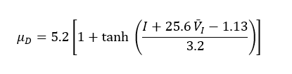
where I denotes earthquake intensity based on the Modified Mercalli Intensity (MMI) scale, andV I
Findings
In order to assess the vulnerability of buildings in Oshnavieh City to earthquakes, the results obtained from the analytical procedures were presented in the form of an urban structural vulnerability zonation, as described below.
Stage 1: Data input
At the initial stage, the input layers, including vector and raster data corresponding to each research criterionwere introduced into the GIS environment as part of the vulnerability zonation project. These layers constituted the foundational datasets required for subsequent spatial analysis.
Stage 2: Valuation and standardization of criterion maps
Valuation refers to assigning values to the measured criteria based on their degree of desirability or contribution to vulnerability. For example, an increase in slope was assumed to lead to a higher level of vulnerability of urban structures, indicating a direct relationship. Conversely, an increase in distance from fault lines was associated with reduced vulnerability, reflecting an inverse relationship. In the present study, valuation and standardization were conducted simultaneously based on fuzzy membership values. Accordingly, fuzzy linear and sigmoidal membership functions—implemented in increasing or decreasing forms as appropriate—were applied using GIS and Idrisi software (version 32). As a result, standardized criterion maps were generated within a range of 0 to 1, where a value of 1 represents maximum vulnerability and 0 represents minimum vulnerability. Given the relatively small extent of the study area and the limited influence of distance from faults on residential vulnerability, the fault buffer criterion was ultimately excluded from the analysis.
Stage 3: Considerations in weighting the criteria
In analyzing the vulnerability of urban buildings to earthquakes, several indicators—such as structural type, building age, number of stories, and distance-related factors—were found to influence vulnerability to varying degrees. The final weights of the selected criteria were calculated with a consistency ratio of 0.07, which is below the acceptable threshold of 0.10, indicating that the weighting results are reliable. Based on the model outputs, structural type received the highest weight (0.243), whereas slope had the lowest weight (0.022), reflecting their relative importance in determining vulnerability.
Stage 4: Determination of the utility (S) and regret (R) indices
At this stage, the maximum and minimum values of the criterion functions were determined across all spatial layers. These values were then used to calculate the utility and regret measures required for the VIKOR analysis.
Stage 5: Calculation of the VIKOR (Q) index
The VIKOR index values ranged from 0.14 to 0.97. To analyze the existing conditions, the final VIKOR output was classified into five vulnerability levels, ranging from very low to very high. The results indicate that Neighborhoods 2 and 3, along with parts of Neighborhoods 6, 11, and 12, exhibited lower vulnerability levels due to the use of durable construction materials and compliance with national building standards, including the Iranian Seismic Code (Standard No. 2800). In contrast, other neighborhoods of Oshnavieh City, particularly Neighborhoods 1, 4, 5, and 7 showed relatively high vulnerability, primarily due to the use of low-durability materials and the advanced age of buildings.
For a more detailed examination, quantitative results were extracted. Across the entire city, only 805 buildings, approximately 9.19% of urban buildings and housing units were classified as having very low vulnerability.
Stage 6: Earthquake scenario design with different intensity levels
Based on the mean damage intensity formula, the vulnerability of buildings in Oshnavieh City was analyzed under three earthquake scenarios with intensities of 6, 7, and 8 on the Modified Mercalli scale. The statistical distribution of building damage under these different intensities demonstrates that, across all three scenarios, Neighborhoods 1, 4, 5, and 7 experienced higher levels of damage compared to other areas. The high vulnerability in these neighborhoods is attributed to the use of low-durability materials such as brick, adobe, and wood; the advanced age and poor quality of buildings; narrow street widths; and the lack of compliance with building regulations.
Conversely, Neighborhoods 2 and 3 exhibited the lowest levels of damage among all neighborhoods. This lower vulnerability can be explained by the use of durable construction materials (steel and reinforced concrete frames), newer buildings, neighborhood renewal initiatives, and adherence to earthquake-resistant building design standards.
Overall, the results indicate that in a potential earthquake with an intensity of 8 on the Modified Mercalli scale, approximately 4,308 buildings (49.21%) in Oshnavieh City would be completely destroyed, 1,182 buildings (13.51%) would suffer severe damage, and 426 buildings (4.86%) would experience minor damage. The quantitative results clearly demonstrate the high level of seismic vulnerability of the study area.
Discussion
Today, one of the most important concerns of urban authorities is reducing the impacts of earthquakes on urban residents and environments, both before and after their occurrence. In this regard, identifying urban neighborhoods that are vulnerable to earthquakes is essential. By recognizing high-risk areas, it becomes possible to improve the physical condition of buildings and enhance emergency services through appropriate planning, thereby enabling the rapid provision of services in the event of an earthquake and reducing overall vulnerability. Accordingly, the present study was conducted through several operational phases. Based on criteria influencing vulnerability analysis, criterion maps were prepared, followed by their valuation and standardization using a fuzzy logic approach. The Analytic Hierarchy Process (AHP) was applied to weight the criterion maps, and the VIKOR multi-criteria decision-making technique was employed to determine the overall vulnerability of buildings in Oshnavieh City.
The results of the overall vulnerability map derived from the VIKOR method indicate that approximately 9.19% of urban buildings and residential units exhibit very low vulnerability, while about 45.58% fall within the high and very high vulnerability classes. These findings clearly demonstrate the considerable seismic vulnerability of neighborhoods in Oshnavieh City. To provide a more precise assessment of building vulnerability, the overall vulnerability map was fuzzified, and earthquake scenarios with different intensity levels were designed and applied. The analysis of vulnerability levels under three earthquake scenarios with intensities ranging from 6 to 8 on the Modified Mercalli scale revealed that buildings located in Neighborhoods 1, 4, 5, and 7 experience higher levels of damage across all scenarios compared to other neighborhoods. Conversely, the scenario-based results indicate that Neighborhoods 2 and 3 would suffer the least damage. The lower vulnerability of these neighborhoods can be attributed to the use of durable and stable construction materials, the relatively newer age of buildings, and neighborhood renewal initiatives. These findings are consistent with studies by Tabibian and Mozafari (2018), which have emphasized physical indicators, and by Ratiranjan et al. (2020), which have focused on natural indicators, as well as with the vulnerability mapping outputs and integrated modeling approaches reported by Yariyan et al. (2020).
Urban planning plays a critical role in reducing a city’s vulnerability to earthquakes. Among various dimensions of physical urban planning, land use, transportation networks, urban infrastructure, balanced population distribution, building age and quality, construction materials, distance from fault lines, and compliance with building regulations are key factors that significantly influence the mitigation of earthquake impacts and consequences. In line with the findings of this study, the implementation of the following measures can contribute to reducing the vulnerability of neighborhoods in Oshnavieh City: retrofitting and strengthening old and deteriorated buildings; preventing the construction of high-density buildings; providing open spaces on at least two sides of new constructions; offering renovation fee reductions for buildings constructed with low-durability and unstable materials; increasing street permeability in highly vulnerable neighborhoods; and conducting detailed assessments of urban structural vulnerability during earthquakes and preparing vulnerability maps to support planning and decision-making aimed at reducing earthquake-related losses.
It should be noted that the present study focused exclusively on direct seismic vulnerability, and secondary hazards following earthquakes were not examined. Consequently, related indicators, primarily associated with the safety of urban utilities such as electricity and gas systems to prevent fires and explosions, were not considered. This omission constitutes one of the main limitations of the present research.
Conclusion
With regard to the vulnerability of urban areas in Oshnavieh City to earthquakes, there are significant risks to both human life and property. Therefore, it is essential for urban managers and decision-makers to review and revise existing laws, regulations, urban development plans, and current approaches to urban management and spatial planning in order to reduce seismic risks and enhance urban resilience.
Acknowledgments: No acknowledgments were reported by the authors.
Ethical Permission: No ethical issues were reported by the authors.
Conflict of Interest: The first author is a faculty member of Payame Noor University, and this article is the result of the research activities and fieldwork conducted by both authors.
Author Contributions: Houshyar H (first author), Introduction Writer/Methodologist/Discussion Writer (60%); Ramazantash Dehgorje H (second author), Assistant researcher (40%)
Funding: No funding was reported by the authors.
Natural hazards have caused approximately three million fatalities worldwide over the past 25 years and have resulted in nearly USD 23 billion in economic losses [Modiri et al., 2018]. Today, the vulnerability of human settlements to natural hazards has emerged as a major challenge to global development [Ratiranjan & Biswajeet, 2020]. In most parts of the world, due to factors such as inappropriate physical development, non-compliance with urban planning principles and regulations, excessive concentration of population and buildings in earthquake-prone areas, and improper site selection, settlements are continuously exposed to risks associated with natural disasters [Federico et al., 2021]. Therefore, in order to reduce natural hazards, the standardization of construction materials and the enhancement of safety and reliability in new developments should be prioritized [Sadeghi et al., 2018].
Earthquakes are natural phenomena whose neglect leads to irreparable damage [Amini et al., 2015]. During the twentieth century, more than 1,100 destructive earthquakes occurred worldwide, resulting in over 1.5 million fatalities [Hatamine Nejad et al., 2018]; approximately 90% of these deaths were caused by the collapse of buildings that lacked adequate engineering and safety standards [Lantada et al., 2009]. The seismic hazard zonation map of Iran indicates that most urban and non-urban areas are located in zones of high relative seismic risk [Ghaffari et al., 2018]. According to previous studies, nearly 70% of Iran’s territory lies within the world’s seismically active regions, and earthquakes account for the highest proportion of casualties and damages; on average, one major earthquake causing human losses has occurred every ten years over the past millennium [Eshgi Chaharborj et al., 2017]. Moreover, official statistics indicate that over the past 25 years, approximately 6% of human fatalities in Iran have been attributed to earthquakes, with an average occurrence of one magnitude 6 earthquake annually and one magnitude 7 earthquake every ten years [Iranmanesh & Eshraghi, 2006]. An examination of major historical earthquakes in West Azerbaijan Province (such as the Salmas earthquake in June 1837, the Khoy earthquake in 1843, and others) clearly demonstrates that the study area is highly seismically active from a tectonic perspective [Abedini & Sarmasti, 2017]. One of the major faults in the Azerbaijan region is the Oshnavieh Fault [Ahamadi et al., 2019], which extends at least 20 km, passes northwest of Oshnavieh City, and forms the boundary between the mountainous and plain areas. Over the past decade, the occurrence of seven earthquakes and aftershocks with magnitudes ranging from 4.5 to 5.6 has been reported in association with the activity of the Oshnavieh Fault.
Numerous studies have been conducted on earthquake vulnerability and related hazards, some of which have significantly contributed to the theoretical foundation of the present research. Abo El et al. have employed seismic fragility functions to assess earthquake-induced damage in Quebec City, Canada. Their findings indicate that approximately 61% of the considered buildings can withstand a certain degree of damage [Abo El et al., 2015]. In this study, the effect of uncertainty in earthquake prediction on damage estimation was also evaluated. Sarris et al. investigate seismic vulnerability and seismic risk assessment in high-seismicity areas of Chania City on the island of Crete, Greece, using a geographic information system (GIS). Their results suggest that the proposed hazard map and applied model can serve as effective tools for mitigating future earthquake-related crises [Sarris et al., 2009]. In his doctoral dissertation entitled Geographic Information for Measuring Urban Vulnerability to Earthquakes, Botero examines the role of geographic information and spatial data in studies measuring urban vulnerability to earthquakes and, based on spatial data infrastructure, conducted social and physical vulnerability zonation for the city of Medellín, Colombia [Botero, 2009]. In a study entitled Estimation of Earthquake Damage Using the Radius Model and GIS (Case Study: Ashkezar County), researchers have concluded that earthquake-induced damage under two probable seismic scenarios in the study area would be negligible; in the southwest fault scenario, minor damage would occur, whereas in the eastern fault scenario, no damage was expected [Kamranzad et al., 2020]. Sadeghi et al., in a study entitled Analysis and Estimation of Urban Housing Vulnerability to Earthquakes (Case Study: Gorgan City), assess the vulnerability of buildings in Gorgan City. Their results show that approximately 300 ha, equivalent to 17.33% of the total area of Gorgan City, fall within the highly vulnerable zone. Furthermore, the classification of vulnerability levels indicates that residential areas constructed in accordance with the Iranian Seismic Code (Standard No. 2800) are classified as having negligible vulnerability and account for 25.58% of the city’s total built-up areas [Sadeghi et al., 2018]. Alavi et al., in a study entitled Assessment of Urban Fabric Vulnerability Using Network Analysis and GIS (Case Study: Semirom City), have evaluated the urban fabric of Semirom from a vulnerability perspective. By examining indicators such as building quality, land slope, distance from fault lines, and open and green spaces, they have found that vulnerability levels in the northern and central parts of Semirom are higher than in other areas due to proximity to fault lines and the deteriorated condition of buildings [Alavi et al., 2017]. Zare et al. have assessed the vulnerability of deteriorated urban fabrics in Marvdasht City to earthquakes by defining nine indicators, including structural type, building age, construction quality, street width, and population density. The weights of these indicators are determined using the Analytic Hierarchy Process (AHP). The results indicate that areas with high vulnerability comprise approximately 32% of the urban fabric, while areas with moderate vulnerability account for about 31% [Zare et al., 2016]. Meshkini et al., in a study entitled Analysis of Urban Fabric Vulnerability to Earthquakes (Study Area: District 2 of Tehran Municipality), have applied network analysis and fuzzy operators and have concluded that the urban fabric of District 2 of Tehran exhibits moderate to relatively high vulnerability, particularly in the eastern and southern parts of the district [Meshkini et al., 2015].
Given that several earthquakes occur annually in Oshnavieh City and that no prior research has been conducted on this area, a precise understanding of the potential vulnerability of the city’s physical components can play an effective and constructive role in reducing earthquake-induced losses. In this study, the vulnerability status of buildings in Oshnavieh City was analyzed and evaluated based on physical–environmental components using GIS-based multi-criteria decision analysis techniques [Jafari Azar et al., 2018]. Furthermore, to achieve a more accurate assessment of potential damage to urban buildings, several earthquake scenarios with different intensity levels were proposed. Accordingly, the primary objective of the present study was to analyze the buildings of Oshnavieh City from a vulnerability-oriented perspective with an emphasis on earthquake hazards.
Methodology
The present applied research was conducted in 2021–2022 using a quantitative–analytical approach. Oshnavieh City, the administrative center of Oshnavieh County, comprises four rural districts (Northern Oshnavieh, Dasht-e Bil, Southern Oshnavieh, and Heq) and is located 72 km from the capital of West Azerbaijan Province, Urmia. The required data were collected through documentary and library-based reviews, while the base GIS maps used in this study were obtained through field visits to the Technical Office of Oshnavieh Municipality.
To assess and evaluate the vulnerability of buildings in Oshnavieh City, the effective indicators and factors influencing vulnerability in the study area were first identified. Based on an assessment of the existing conditions of Oshnavieh City and data availability, eight key criteria relevant to the research topic were selected, including structural type, building age, building quality, number of stories, parcel area, land use, population density, river buffer, and slope. Subsequently, to determine the weights and relative importance of each criterion, the pairwise comparison method within the framework of the Analytic Hierarchy Process (AHP) was employed. After determining the weights of the selected criteria, criterion maps were prepared in the GIS environment. The VIKOR (VIseKriterijumska Optimizacija I Kompromisno Resenje) technique was then applied to analyze and prioritize the overall vulnerability status of buildings in Oshnavieh City.
Finally, in order to provide a more realistic assessment of urban vulnerability, the urban structures modeled using the VIKOR technique in the ArcGIS 10.2 environment were fuzzified to implement earthquake scenarios with different intensity levels. After converting and standardizing the data to a common scale through fuzzification, earthquake scenarios with varying intensities were designed in the subsequent stage to achieve a more accurate evaluation of vulnerability using the following equation:
where I denotes earthquake intensity based on the Modified Mercalli Intensity (MMI) scale, and
Findings
In order to assess the vulnerability of buildings in Oshnavieh City to earthquakes, the results obtained from the analytical procedures were presented in the form of an urban structural vulnerability zonation, as described below.
Stage 1: Data input
At the initial stage, the input layers, including vector and raster data corresponding to each research criterionwere introduced into the GIS environment as part of the vulnerability zonation project. These layers constituted the foundational datasets required for subsequent spatial analysis.
Stage 2: Valuation and standardization of criterion maps
Valuation refers to assigning values to the measured criteria based on their degree of desirability or contribution to vulnerability. For example, an increase in slope was assumed to lead to a higher level of vulnerability of urban structures, indicating a direct relationship. Conversely, an increase in distance from fault lines was associated with reduced vulnerability, reflecting an inverse relationship. In the present study, valuation and standardization were conducted simultaneously based on fuzzy membership values. Accordingly, fuzzy linear and sigmoidal membership functions—implemented in increasing or decreasing forms as appropriate—were applied using GIS and Idrisi software (version 32). As a result, standardized criterion maps were generated within a range of 0 to 1, where a value of 1 represents maximum vulnerability and 0 represents minimum vulnerability. Given the relatively small extent of the study area and the limited influence of distance from faults on residential vulnerability, the fault buffer criterion was ultimately excluded from the analysis.
Stage 3: Considerations in weighting the criteria
In analyzing the vulnerability of urban buildings to earthquakes, several indicators—such as structural type, building age, number of stories, and distance-related factors—were found to influence vulnerability to varying degrees. The final weights of the selected criteria were calculated with a consistency ratio of 0.07, which is below the acceptable threshold of 0.10, indicating that the weighting results are reliable. Based on the model outputs, structural type received the highest weight (0.243), whereas slope had the lowest weight (0.022), reflecting their relative importance in determining vulnerability.
Stage 4: Determination of the utility (S) and regret (R) indices
At this stage, the maximum and minimum values of the criterion functions were determined across all spatial layers. These values were then used to calculate the utility and regret measures required for the VIKOR analysis.
Stage 5: Calculation of the VIKOR (Q) index
The VIKOR index values ranged from 0.14 to 0.97. To analyze the existing conditions, the final VIKOR output was classified into five vulnerability levels, ranging from very low to very high. The results indicate that Neighborhoods 2 and 3, along with parts of Neighborhoods 6, 11, and 12, exhibited lower vulnerability levels due to the use of durable construction materials and compliance with national building standards, including the Iranian Seismic Code (Standard No. 2800). In contrast, other neighborhoods of Oshnavieh City, particularly Neighborhoods 1, 4, 5, and 7 showed relatively high vulnerability, primarily due to the use of low-durability materials and the advanced age of buildings.
For a more detailed examination, quantitative results were extracted. Across the entire city, only 805 buildings, approximately 9.19% of urban buildings and housing units were classified as having very low vulnerability.
Stage 6: Earthquake scenario design with different intensity levels
Based on the mean damage intensity formula, the vulnerability of buildings in Oshnavieh City was analyzed under three earthquake scenarios with intensities of 6, 7, and 8 on the Modified Mercalli scale. The statistical distribution of building damage under these different intensities demonstrates that, across all three scenarios, Neighborhoods 1, 4, 5, and 7 experienced higher levels of damage compared to other areas. The high vulnerability in these neighborhoods is attributed to the use of low-durability materials such as brick, adobe, and wood; the advanced age and poor quality of buildings; narrow street widths; and the lack of compliance with building regulations.
Conversely, Neighborhoods 2 and 3 exhibited the lowest levels of damage among all neighborhoods. This lower vulnerability can be explained by the use of durable construction materials (steel and reinforced concrete frames), newer buildings, neighborhood renewal initiatives, and adherence to earthquake-resistant building design standards.
Overall, the results indicate that in a potential earthquake with an intensity of 8 on the Modified Mercalli scale, approximately 4,308 buildings (49.21%) in Oshnavieh City would be completely destroyed, 1,182 buildings (13.51%) would suffer severe damage, and 426 buildings (4.86%) would experience minor damage. The quantitative results clearly demonstrate the high level of seismic vulnerability of the study area.
Discussion
Today, one of the most important concerns of urban authorities is reducing the impacts of earthquakes on urban residents and environments, both before and after their occurrence. In this regard, identifying urban neighborhoods that are vulnerable to earthquakes is essential. By recognizing high-risk areas, it becomes possible to improve the physical condition of buildings and enhance emergency services through appropriate planning, thereby enabling the rapid provision of services in the event of an earthquake and reducing overall vulnerability. Accordingly, the present study was conducted through several operational phases. Based on criteria influencing vulnerability analysis, criterion maps were prepared, followed by their valuation and standardization using a fuzzy logic approach. The Analytic Hierarchy Process (AHP) was applied to weight the criterion maps, and the VIKOR multi-criteria decision-making technique was employed to determine the overall vulnerability of buildings in Oshnavieh City.
The results of the overall vulnerability map derived from the VIKOR method indicate that approximately 9.19% of urban buildings and residential units exhibit very low vulnerability, while about 45.58% fall within the high and very high vulnerability classes. These findings clearly demonstrate the considerable seismic vulnerability of neighborhoods in Oshnavieh City. To provide a more precise assessment of building vulnerability, the overall vulnerability map was fuzzified, and earthquake scenarios with different intensity levels were designed and applied. The analysis of vulnerability levels under three earthquake scenarios with intensities ranging from 6 to 8 on the Modified Mercalli scale revealed that buildings located in Neighborhoods 1, 4, 5, and 7 experience higher levels of damage across all scenarios compared to other neighborhoods. Conversely, the scenario-based results indicate that Neighborhoods 2 and 3 would suffer the least damage. The lower vulnerability of these neighborhoods can be attributed to the use of durable and stable construction materials, the relatively newer age of buildings, and neighborhood renewal initiatives. These findings are consistent with studies by Tabibian and Mozafari (2018), which have emphasized physical indicators, and by Ratiranjan et al. (2020), which have focused on natural indicators, as well as with the vulnerability mapping outputs and integrated modeling approaches reported by Yariyan et al. (2020).
Urban planning plays a critical role in reducing a city’s vulnerability to earthquakes. Among various dimensions of physical urban planning, land use, transportation networks, urban infrastructure, balanced population distribution, building age and quality, construction materials, distance from fault lines, and compliance with building regulations are key factors that significantly influence the mitigation of earthquake impacts and consequences. In line with the findings of this study, the implementation of the following measures can contribute to reducing the vulnerability of neighborhoods in Oshnavieh City: retrofitting and strengthening old and deteriorated buildings; preventing the construction of high-density buildings; providing open spaces on at least two sides of new constructions; offering renovation fee reductions for buildings constructed with low-durability and unstable materials; increasing street permeability in highly vulnerable neighborhoods; and conducting detailed assessments of urban structural vulnerability during earthquakes and preparing vulnerability maps to support planning and decision-making aimed at reducing earthquake-related losses.
It should be noted that the present study focused exclusively on direct seismic vulnerability, and secondary hazards following earthquakes were not examined. Consequently, related indicators, primarily associated with the safety of urban utilities such as electricity and gas systems to prevent fires and explosions, were not considered. This omission constitutes one of the main limitations of the present research.
Conclusion
With regard to the vulnerability of urban areas in Oshnavieh City to earthquakes, there are significant risks to both human life and property. Therefore, it is essential for urban managers and decision-makers to review and revise existing laws, regulations, urban development plans, and current approaches to urban management and spatial planning in order to reduce seismic risks and enhance urban resilience.
Acknowledgments: No acknowledgments were reported by the authors.
Ethical Permission: No ethical issues were reported by the authors.
Conflict of Interest: The first author is a faculty member of Payame Noor University, and this article is the result of the research activities and fieldwork conducted by both authors.
Author Contributions: Houshyar H (first author), Introduction Writer/Methodologist/Discussion Writer (60%); Ramazantash Dehgorje H (second author), Assistant researcher (40%)
Funding: No funding was reported by the authors.
References
1. Abedini M, Sarmasti N (2016). Vulnerability factor of Tabriz metropolitan against earthquake risk assessment and estimation of casualties. Physical Geography Quarterly. 9(32):35-56. [Persian] [Link]
2. Abo El Ezz A, Nollet MJ, Nastev M (2015). Assessment of earthquake-induced damage in Quebec City, Canada. International Journal of Disaster Risk Reduction. (12):16-24. [Link] [DOI:10.1016/j.ijdrr.2014.11.004]
3. Ahamadi A, Fathi S, Akbari E (2019). Assessment of urban resilience against natural hazards with an emphasis on earthquake and using fuzzy logic and GIS (a case study of Urmia city). Journal of Geography and Environmental Hazards. 7(3):57-73. [Persian] [Link]
4. Alavi S, Hosseini S, Bahrami F, Ashorlo M (2017). Evaluation of urban fabric vulnerability rateto earthquake using ANP and GIS techniques (Case study: Semirom city). Scientific - Research Quarterly of Geographical Data (SEPEHR). 25(100):129-146. [Persian] [Link]
5. Amini J, Ahadnezhad M, Farajzadeh M (2015). The vulnerability assessment of urban housing in earthquake against (a case study: 9th district of Tehran municipality). Urban Regional Studies and Research.3(9):19-36. [Persian] [Link]
6. Botero V (2009). Geo-information for measuring vulnerability to earthquake: a fitness for use approach [dissertation]. Netherland: ITC. [Link]
7. Eshghi Chaharborj A, Nazmfar H, Ghaffari A (2017). Assessing the physical resilience of a city against possible earthquakes (Case Study: region one of Tehran). Journal of Physical Development Planning. 2(4):11-26. [Persian] [Link]
8. Federico R, Silvia C, Walter S, Tiago M, Paulo B (2021). An improved seismic vulnerability assessment approach for historical urban centres: the case study of Campi Alto di Norcia, Italy. Applied Sciences. 11(2):849. [Link] [DOI:10.3390/app11020849]
9. Ghaffari A, Yazdani M, Gholami, A (2018). Land suitability analysis in locating compost production centers (case study: Fars province). Geography and Environmental Planning (University of Isfahan). 29(1):127-152. [Persian] [Link]
10. Hatami Nejad H, Haraeini M, Alizade P (2018). An analysis of cultural facility distribution in the cities of Qazvin province. Journal of Regional Planning. 8 (30):67-76. [Persian] [Link]
11. Iranmanesh F, Eshraghi M (2006). Application of GIS in planning and location of evacuation spaces of earthquake-affected population's Case study: District 22 of Tehran. Third Conference on Spatial Information System, Tehran, Iran Mapping Organization. Tehran: CIVILICA. [Persian] [Link]
12. Jafari Azar S, Sabzghabaei GH, Tavakoly M, Dashti S (2018). Application of multi-criteria decision-making methods in environmental risk assessment (case study: the international wetland of Shadegan, Khur_e_ Omayyeh and Khur_e_Mousa Estuary). Journal of Geography and Environment Hazards. 6(4):97-119. [Persian] [Link]
13. Kamranzad F, Memarian H, Zare M (2020). Earthquake risk assessment for Tehran, Iran. International Journal of Geo-Information. 9(7):430. [Link] [DOI:10.3390/ijgi9070430]
14. Lantada N, Pujades L, Barbat, A (2009). Vulnerability index and capacity spectrum, based method for urban seismic risk evaluation. Natural Hazards. 51(3):501-524. [Link] [DOI:10.1007/s11069-007-9212-4]
15. Meshkini A, Ghaed Rahmati S, Shabanzadeh Namini R (2015). Analysis of urban fabric vulnerability against earthquake (Case study: Tehran, District 2). Human Geography Research Quarterly. 46(4):843-856. [Link]
16. Modiri M, Shaterian M, Hosseini, S (2017). Modeling the vulnerability of urban areas at the time of earthquake (Case study: Tehran metropolitan area 3). Journal of Natural Environment Hazards.13(4):143-164. [Persian] [Link]
17. Ratiranjan J, Biswajeet P, Ghassan B (2020). Earthquake vulnerability assessment in Northern Sumatra province by using a multi-criteria decision-making model. International Journal of Disaster Risk Reduction. 46:101518-101530. [Link] [DOI:10.1016/j.ijdrr.2020.101518]
18. Ratiranjan J, Biswajeet P, Ghassan B, Abdullah M, Ardiansyahe N, Hizir S (2020). Earquake hazard and risk assessment using machine learning approaches at Palu, Indonesia. Science of the Total Environment. 749(141582). [Link] [DOI:10.1016/j.scitotenv.2020.141582]
19. Sadeghi N, Bezi Kh, Khajeh Shokouhi A, Rezaei H (2018). Analysis and estimation of earthquake vulnerability of urban housing case study: Gorgan. Journal of Environmental Geography. 7(25):73-88. [Persian] [Link]
20. Sarris A, Loupasakis C, Soupios P, Trigkas V, Vallianatos F (2009). Earthquake vulnerability and seismic risk assessment of urban areas in high seismic regions: application to Chania City, Crete Island, Greece. Natural Hazards. 54:395-412. [Link] [DOI:10.1007/s11069-009-9475-z]
21. Tabibian M, Mozafari N (2018). Assessment of vulnerability of residential areas to earthquake disasters and its planning guidelines (case study: District number 6, Tehran municipality). MOTALEATE SHAHRI. 7(27):93-112. [Persian] [Link]
22. Yariyan P, Avand M, Soltani F, Ghorbanzadeh O, Blaschke T (2020). Earthquake vulnerability mapping using different hybrid models. Symmetry. 12(3):405. [Link] [DOI:10.3390/sym12030405]
23. Zare M, Rezaei M, Rahimi A (2016). Vulnerability assessment of eroded tissue of Marvdasht city against earthquake using ANP and GIS. Journal of Urban Research and Planning. 7(26):75-92. [Persian] [Link]