

Bilingual
En/Fa
Geographical Research is Published in both Persian and English Full-text.
Volume 40, Issue 4 (2025)
GeoRes 2025, 40(4): 339-346 |
Back to browse issues page
Article Type:
Subject:


History
Received: 2025/10/28 | Accepted: 2025/12/7 | Published: 2025/12/18
Received: 2025/10/28 | Accepted: 2025/12/7 | Published: 2025/12/18
How to cite this article
Lak A, Meihami F. Optimal Site Selection of Natural Gas Fuel Supply Stations in Mahabad City. GeoRes 2025; 40 (4) :339-346
URL: http://georesearch.ir/article-1-1873-en.html
URL: http://georesearch.ir/article-1-1873-en.html
Download citation:
BibTeX | RIS | EndNote | Medlars | ProCite | Reference Manager | RefWorks
Send citation to:


Rights and permissions
BibTeX | RIS | EndNote | Medlars | ProCite | Reference Manager | RefWorks
Send citation to:

Authors
A.R. Lak1, F. Meihami *2
1- Department of Industrial Engineering, School of Industrial and Systems Engineering, Faculty of Engineering, University of Tehran, Tehran, Iran
2- Department of Environmental Science and Engineering, Faculty of Natural Resources, University of Kurdistan, Kurdistan, Iran
2- Department of Environmental Science and Engineering, Faculty of Natural Resources, University of Kurdistan, Kurdistan, Iran
Full-Text (HTML) (57 Views)
Background
Rapid urbanization, increasing transportation demand, and dependence on fossil fuels have turned the management and optimal location of fuel supply stations into one of the major challenges of urban planning. The inappropriate distribution of these land uses can lead to traffic congestion, spatial inequality, and safety and environmental hazards; therefore, scientific site selection based on technical and environmental criteria is essential for achieving sustainable urban development.
Previous Studies
Numerous studies at both international and national levels have addressed the optimal location of fuel supply stations. At the global level, research using network-based approaches and coverage models has examined the optimization of these land uses from the perspective of transportation network efficiency and accessibility [Aleisa et al., 2014; Kar & Hodgson, 2008; Wang et al., 2016]. In Iran, several studies have been conducted using GIS and multi-criteria decision-making models. For example, Salmani Moghadam et al. in District 4 of Tehran, using AHP, have shown that population density, road network, slope, and incompatible land uses are among the most influential factors in locating CNG stations [Salmani Moghadam et al., 2018]. Nasirihendekhaleh et al., applying a GIS-AHP model in western Tehran, have found that only 29% of stations were located in suitable zones [Nasirihendekhaleh et al., 2020]. Furthermore, Abdi et al. in Rasht, through GIS analysis, pointed to the spatial imbalance of fuel stations [Abdi et al., 2013].
Aim(s)
The aim of the present study is the optimal site selection of CNG fuel supply stations in the city of Mahabad using the GIS environment and multi-criteria decision-making models (AHP–MCE).
Research Type
The present study was applied–descriptive in nature.
Research Society, Place and Time
The research population includes the urban area of Mahabad and all physical zones, land uses, and infrastructures related to the location of CNG fuel supply stations in this city. This study was conducted in the year 2024 in the Iranian calendar.
Sampling Method and Number
Not applicable.
Used Devices & Materials
In this study, spatial data analysis was conducted using GIS software for data preparation, processing, rasterization, standardization, and spatial modeling. The Analytical Hierarchy Process (AHP) was implemented through Expert Choice software (Version 11) to determine the relative weights of the criteria based on pairwise comparisons using Saaty’s 1–9 scale. Multi-Criteria Evaluation (MCE) was applied, and the Weighted Linear Combination (WLC) method was used to integrate the weighted criteria layers. Fuzzy membership functions were employed to standardize the factors into a continuous suitability scale ranging from 0 to 1, while constraints were defined in binary form (0 and 1).
The materials and datasets included digital spatial layers such as topography, land use, road network, fault lines, rivers, fire station service areas, administrative and commercial centers, existing CNG stations, and environmental features such as parks and green spaces. These data were obtained from official sources including the National Cartographic Center, the Gas Department, and the Municipality of Mahabad, as well as documentary studies, library data, and satellite imagery. All layers were prepared at a base scale of 1:25,000 and processed for spatial analysis.
Findings
In this study, the criteria affecting the location of CNG stations were first standardized using fuzzy membership functions, and the output maps for each criterion, including geology, slope, elevation, distance from roads, distance from existing CNG stations, soil, distance from administrative and commercial centers, distance from fire stations, land use type, distance from faults, distance from parks and green spaces, and distance from rivers, were produced (Figure 2). Then, to implement the WLC method, the weights of the criteria were determined using the Analytical Hierarchy Process (AHP) in ArcMap 10.3 (Figure 3). The inconsistency ratio (CR=0.07) indicated acceptable validity and consistency of the pairwise comparisons. The weighting results showed that distance from urban roads had the greatest importance in site selection, followed by distance from fire stations and land use type, while distance from parks and green spaces and elevation received the lowest weights.
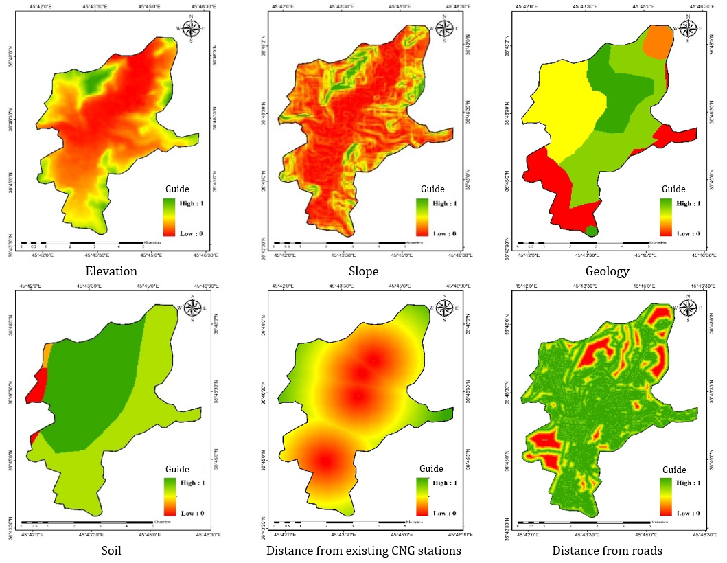
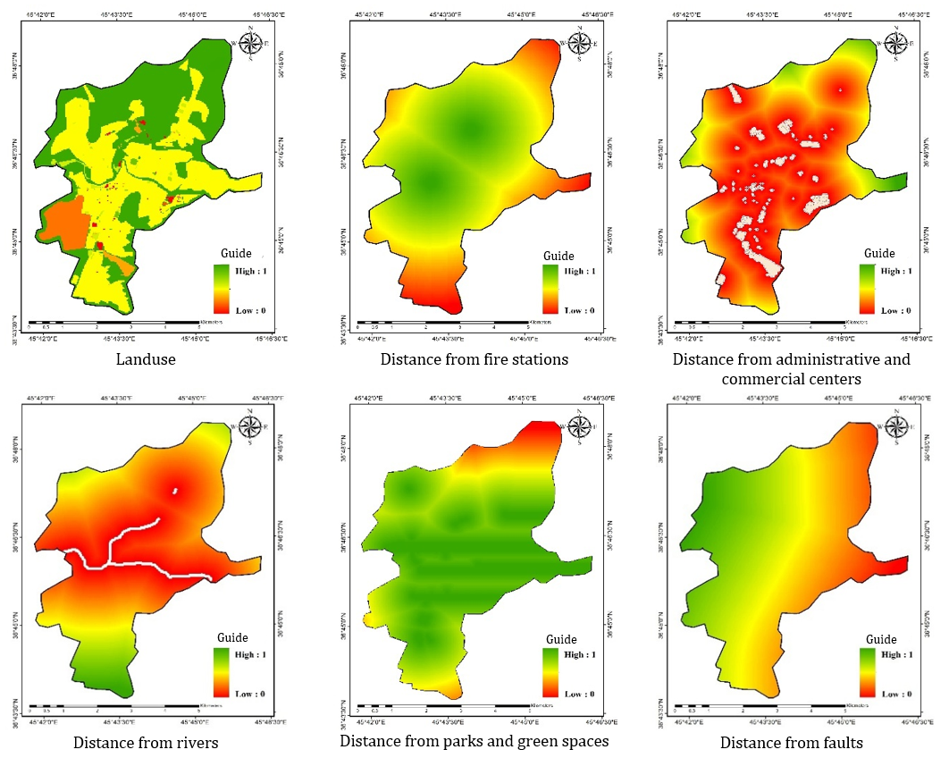
Figure 2. Fuzzy output maps of the selected criteria in the study
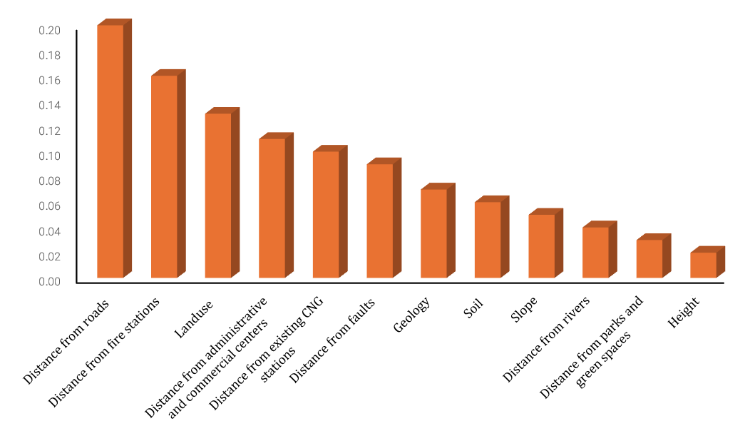
Figure 3. Weights assigned to each criterion using the AHP method
In the final stage, the weighted layers were integrated in the GIS environment, and the final suitability map was produced using the WLC method within a range of 0 to 1 (Figure 4), where areas with the highest potential were marked in green. The map was then classified into four categories: completely unsuitable, unsuitable, suitable, and completely suitable (Figure 5). The results showed that the largest area of Mahabad falls within the completely suitable class (885 hectares, 33.3%), followed by the suitable class (716 hectares, 27%). In contrast, unsuitable (702 hectares, 26.4%) and completely unsuitable (357.7 hectares, 13.45%) zones constitute a considerable portion of the urban area. Overall, about 60% of the city area has suitable to completely suitable conditions for the establishment of CNG stations. Moreover, comparison of the final suitability map with the locations of existing stations indicated that all four active stations are located within suitable and completely suitable zones, demonstrating a relative consistency between the current site selection and the model results.
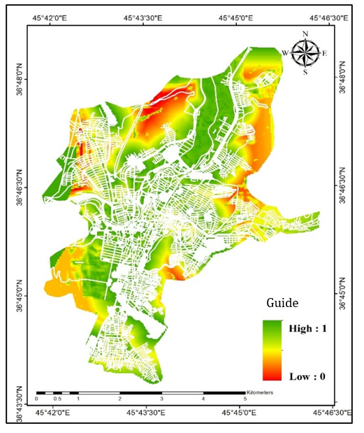
Figure 4. Final site suitability map for CNG fuel supply stations
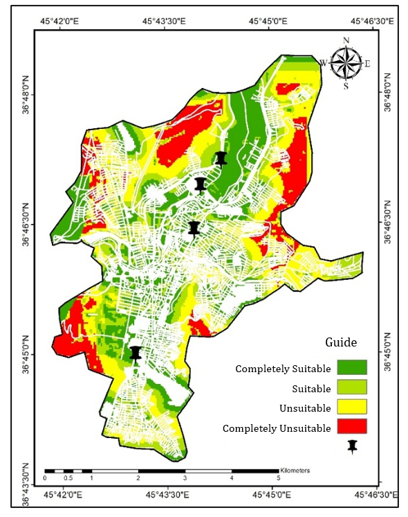
Figure 5. Classified site suitability map for CNG fuel supply stations
Main Comparisons to Similar Studies
The findings of the present study are consistent with previous research on fuel infrastructure site selection using GIS and multi-criteria decision-making models; as emphasized in Kar & Hodgson (2008) and Wang et al. (2016), the integrated GIS–MCE approach is highly effective. The 60% share of suitable and completely suitable zones in Mahabad aligns with findings from studies conducted in various Iranian cities such as Shiraz, Rasht, Zanjan, Ahvaz, and western Tehran, which reported a range between 55% and 70% [Abdi et al., 2013; Mohammadi & Rezaei, 2012; Nasirihendekhaleh et al., 2020; Shabani & Dashti, 2024]. The reduced proportion of completely suitable zones in this study, compared with some previous research, is similar to the findings of Alavi et al. (2016) and Salmani Moghadam et al. (2018), indicating that increasing restrictive criteria reduces highly suitable zones while enhancing model precision. Furthermore, the emphasis on accessibility and distance from roads is consistent with the studies of Aleisa et al. (2014), Mahmood et al. (2015), Mohammed et al. (2014), and Nowbakht & Mostafavi (2011). The importance of safety considerations is also in line with the findings of Arabameri (2014), Modiri et al. (2016), and Chinese et al. (2014). Finally, the greater influence of human-made factors compared to natural criteria corresponds with the results of Akbari & Kavian (2017) and Amini et al. (2019), and the consistency of existing station locations with suitable zones is similar to the findings of Mohammadi et al. (2016) and Nasirihendekhaleh et al. (2020).
Suggestions
The results of this study can serve as a scientific basis for urban managers in developing clean fuel infrastructure, reducing environmental hazards, and improving the safety and efficiency of the urban transportation system; an issue that has been widely emphasized in contemporary urban and energy planning literature.
Conclusion
Distance from urban roads and distance from fire stations have the greatest importance in the site selection of CNG stations in Mahabad, while elevation and distance from green spaces and rivers have the least influence. Overall, approximately 60% of the urban area has suitable to completely suitable potential.
Acknowledgments: The authors of this article express their sincere appreciation and gratitude to the managers of the Municipality of Mahabad for their cooperation and for providing the required data.
Ethical Permission: None reported by the authors.
Conflict of Interest: This article is the result of an independent research conducted by the authors and has not been extracted from a thesis or dissertation.
Authors’ Contributions: Lak AR (First author), Main Researcher/Discussion Writer (75%); Meihami F (Second author), Methodologist/Introduction Writer (25%)
Funding: None reported by the authors.
Rapid urbanization, increasing transportation demand, and dependence on fossil fuels have turned the management and optimal location of fuel supply stations into one of the major challenges of urban planning. The inappropriate distribution of these land uses can lead to traffic congestion, spatial inequality, and safety and environmental hazards; therefore, scientific site selection based on technical and environmental criteria is essential for achieving sustainable urban development.
Previous Studies
Numerous studies at both international and national levels have addressed the optimal location of fuel supply stations. At the global level, research using network-based approaches and coverage models has examined the optimization of these land uses from the perspective of transportation network efficiency and accessibility [Aleisa et al., 2014; Kar & Hodgson, 2008; Wang et al., 2016]. In Iran, several studies have been conducted using GIS and multi-criteria decision-making models. For example, Salmani Moghadam et al. in District 4 of Tehran, using AHP, have shown that population density, road network, slope, and incompatible land uses are among the most influential factors in locating CNG stations [Salmani Moghadam et al., 2018]. Nasirihendekhaleh et al., applying a GIS-AHP model in western Tehran, have found that only 29% of stations were located in suitable zones [Nasirihendekhaleh et al., 2020]. Furthermore, Abdi et al. in Rasht, through GIS analysis, pointed to the spatial imbalance of fuel stations [Abdi et al., 2013].
Aim(s)
The aim of the present study is the optimal site selection of CNG fuel supply stations in the city of Mahabad using the GIS environment and multi-criteria decision-making models (AHP–MCE).
Research Type
The present study was applied–descriptive in nature.
Research Society, Place and Time
The research population includes the urban area of Mahabad and all physical zones, land uses, and infrastructures related to the location of CNG fuel supply stations in this city. This study was conducted in the year 2024 in the Iranian calendar.
Sampling Method and Number
Not applicable.
Used Devices & Materials
In this study, spatial data analysis was conducted using GIS software for data preparation, processing, rasterization, standardization, and spatial modeling. The Analytical Hierarchy Process (AHP) was implemented through Expert Choice software (Version 11) to determine the relative weights of the criteria based on pairwise comparisons using Saaty’s 1–9 scale. Multi-Criteria Evaluation (MCE) was applied, and the Weighted Linear Combination (WLC) method was used to integrate the weighted criteria layers. Fuzzy membership functions were employed to standardize the factors into a continuous suitability scale ranging from 0 to 1, while constraints were defined in binary form (0 and 1).
The materials and datasets included digital spatial layers such as topography, land use, road network, fault lines, rivers, fire station service areas, administrative and commercial centers, existing CNG stations, and environmental features such as parks and green spaces. These data were obtained from official sources including the National Cartographic Center, the Gas Department, and the Municipality of Mahabad, as well as documentary studies, library data, and satellite imagery. All layers were prepared at a base scale of 1:25,000 and processed for spatial analysis.
Findings
In this study, the criteria affecting the location of CNG stations were first standardized using fuzzy membership functions, and the output maps for each criterion, including geology, slope, elevation, distance from roads, distance from existing CNG stations, soil, distance from administrative and commercial centers, distance from fire stations, land use type, distance from faults, distance from parks and green spaces, and distance from rivers, were produced (Figure 2). Then, to implement the WLC method, the weights of the criteria were determined using the Analytical Hierarchy Process (AHP) in ArcMap 10.3 (Figure 3). The inconsistency ratio (CR=0.07) indicated acceptable validity and consistency of the pairwise comparisons. The weighting results showed that distance from urban roads had the greatest importance in site selection, followed by distance from fire stations and land use type, while distance from parks and green spaces and elevation received the lowest weights.
Figure 2. Fuzzy output maps of the selected criteria in the study
Figure 3. Weights assigned to each criterion using the AHP method
In the final stage, the weighted layers were integrated in the GIS environment, and the final suitability map was produced using the WLC method within a range of 0 to 1 (Figure 4), where areas with the highest potential were marked in green. The map was then classified into four categories: completely unsuitable, unsuitable, suitable, and completely suitable (Figure 5). The results showed that the largest area of Mahabad falls within the completely suitable class (885 hectares, 33.3%), followed by the suitable class (716 hectares, 27%). In contrast, unsuitable (702 hectares, 26.4%) and completely unsuitable (357.7 hectares, 13.45%) zones constitute a considerable portion of the urban area. Overall, about 60% of the city area has suitable to completely suitable conditions for the establishment of CNG stations. Moreover, comparison of the final suitability map with the locations of existing stations indicated that all four active stations are located within suitable and completely suitable zones, demonstrating a relative consistency between the current site selection and the model results.
Figure 4. Final site suitability map for CNG fuel supply stations
Figure 5. Classified site suitability map for CNG fuel supply stations
Main Comparisons to Similar Studies
The findings of the present study are consistent with previous research on fuel infrastructure site selection using GIS and multi-criteria decision-making models; as emphasized in Kar & Hodgson (2008) and Wang et al. (2016), the integrated GIS–MCE approach is highly effective. The 60% share of suitable and completely suitable zones in Mahabad aligns with findings from studies conducted in various Iranian cities such as Shiraz, Rasht, Zanjan, Ahvaz, and western Tehran, which reported a range between 55% and 70% [Abdi et al., 2013; Mohammadi & Rezaei, 2012; Nasirihendekhaleh et al., 2020; Shabani & Dashti, 2024]. The reduced proportion of completely suitable zones in this study, compared with some previous research, is similar to the findings of Alavi et al. (2016) and Salmani Moghadam et al. (2018), indicating that increasing restrictive criteria reduces highly suitable zones while enhancing model precision. Furthermore, the emphasis on accessibility and distance from roads is consistent with the studies of Aleisa et al. (2014), Mahmood et al. (2015), Mohammed et al. (2014), and Nowbakht & Mostafavi (2011). The importance of safety considerations is also in line with the findings of Arabameri (2014), Modiri et al. (2016), and Chinese et al. (2014). Finally, the greater influence of human-made factors compared to natural criteria corresponds with the results of Akbari & Kavian (2017) and Amini et al. (2019), and the consistency of existing station locations with suitable zones is similar to the findings of Mohammadi et al. (2016) and Nasirihendekhaleh et al. (2020).
Suggestions
The results of this study can serve as a scientific basis for urban managers in developing clean fuel infrastructure, reducing environmental hazards, and improving the safety and efficiency of the urban transportation system; an issue that has been widely emphasized in contemporary urban and energy planning literature.
Conclusion
Distance from urban roads and distance from fire stations have the greatest importance in the site selection of CNG stations in Mahabad, while elevation and distance from green spaces and rivers have the least influence. Overall, approximately 60% of the urban area has suitable to completely suitable potential.
Acknowledgments: The authors of this article express their sincere appreciation and gratitude to the managers of the Municipality of Mahabad for their cooperation and for providing the required data.
Ethical Permission: None reported by the authors.
Conflict of Interest: This article is the result of an independent research conducted by the authors and has not been extracted from a thesis or dissertation.
Authors’ Contributions: Lak AR (First author), Main Researcher/Discussion Writer (75%); Meihami F (Second author), Methodologist/Introduction Writer (25%)
Funding: None reported by the authors.
References
1. Abdi A, Alavi MPN, Mobasheri H (2013). Allocation of CNG stations in urban street networks based on GIS approach and prioritization with AHP and Topsis methods (case study: Rasht city). Research Journal of Applied Sciences, Engineering and Technology. 5(12):3262-3272. [Link] [DOI:10.19026/rjaset.5.4566]
2. Akbari E, Kavian F (2017). Land suitability analysis for physical urban expansion of Sabzevar City using the Fuzzy Analytical Hierarchy Process (FAHP). Geographical Planning of Space Quarterly Journal. 7(25):89-102. [Persian] [Link]
3. Alavi SA, Moazezbarabadi M, Divsalar A, Jafari B (2016). Location CNG fuel stations by using fusion techniques of fuzzy operators and gis spatial analysis, case study: Mashhad District 7. Urban Ecology Researches. 7(13):9-18. [Persian] [Link]
4. Aleisa E, Savsar M, Al-Mashaan MM, Al-Jadi A, Al-Sabah SA (2014). A metaheuristic approach for location of gas stations in a metropolitan area. International Journal of Operational Research. 21(2):172-200. [Persian] [Link] [DOI:10.1504/IJOR.2014.064543]
5. Amini J, Azizi M, Faramarziasl M (2019). Analysis and evaluation of optimal directions of spatial-physical development of Mahabad city. Journal of Geography and Planning. 22(66):45-66. [Persian] [Link]
6. Arabameri A (2014). Application of the analytic hierarchy process (AHP) for locating fire stations: Case study Maku City. Merit Research Journal of Art, Social Science and Humanities. 2(1):1-10. [Link]
7. Bahadori H, Hasheminezhad A, Borrani M, Karimi A (2017). Optimal site selection for temporary housing after earthquakes (case study: Mahabad city). Journal of Natural Environmental Hazards. 6(13):109-142. [Persian] [Link]
8. Chinese D, Patrizio P, Bonotto M (2014). A service station location model to explore prospects and policies for alternative transport fuels: A case of CNG distribution in Italy. In: Computer-based modelling and optimization in transportation. Cham: Springer. p. 71-84. [Link] [DOI:10.1007/978-3-319-04630-3_6]
9. Ghamrawi A, Maoh H (2024). Modeling the feasibility of fueling CNG heavy-duty trucks in Toronto, Canada. Sydney: Findings Press. [Link] [DOI:10.32866/001c.125061]
10. Hosseinzadeh A, Ahmadi M, Mofrad SM, Ghasemi M (2018). Optimum location of fuel stations (CNG) using fuzzy and AHP (case study: Zanjan). Journal of Geography and Environmental Studies. 6(24):7-20. [Persian] [Link]
11. Kar B, Hodgson ME (2008). A GIS‐based model to determine site suitability of emergency evacuation shelters. Transactions in GIS. 12(2):227-248. [Link] [DOI:10.1111/j.1467-9671.2008.01097.x]
12. Mahmood FH, Shaban AH, Numan SA (2015). Optimal spatial distribution of gasoline stations in Baghdad province utilizing GIS techniques. Iraqi Journal of Science. 56(1C):853-865. [Link]
13. Modiri M, Mohammad A, Moghaddam AR (2016). Spatial organizing and distribution of gas stations following urban passive defense approach (case study: Gas stations of Mashhad Metropolis). Urban and Rural Management. 15(44):39-52. [Link]
14. Mohammadi J, Poorghayoomi H, Ghanbari M (2016). Spatial analysis and site selection fueling stations in Kazeroon. Journal of Research and Urban Planning. 7(1):105-120. [Persian] [Link]
15. Mohammadi J, Rezaei M (2012). Spatial analysis and site selection of CNG Fuel station in Shiraz city. Spatial Planning. 1(4):111-132. [Persian] [Link]
16. Mohammed M, Musa I, Jeb D (2014). GIS-based analysis of the location of filling stations in metropolitan Kano against the physical planning standards. American Journal of Engineering Research. 3(9):147-158. [Link]
17. Nasirihendekhaleh ES, Golmehr E, Hashemi S (2020). Spatial analysis and optimization of urban fuel planning (CNG), case study of west regions of Tehran. Journal of Urban Ecology Researches. 11(22):47-60. [Persian] [Link]
18. Nowbakht S, Mostafavi MA (2011). Optimized location of gas stations using mathematical programming and geographic information systems (GIS), case study of city of Mashhad. Journal of Transportation Engineering. 2(2):171-180. [Persian] [Link]
19. Salmani Moghadam M, Khodabandehlo H, Yousefi F, Samadi M (2018). Optimal location of natural gas refueling stations using geographic information system and AHP model (case study: District 4 of Tehran). Geography and Human Relationships. 1(2):417-438. [Persian] [Link]
20. Shabani P, Dashti S (2024). Site selection of optimum positions of CNG fuel supply using analytical hierarchy process and geographic information system in line with sustainable urban development policy (case study: Ahvaz City). Journal of Urban and Regional Policy. 3(9):21-34. [Persian] [Link]
21. Wang SP, Lee HC, Hsieh YK (2016). A multicriteria approach for the optimal location of gasoline stations being transformed as self‐service in Taiwan. Mathematical Problems in Engineering. (1):8341617. [Link] [DOI:10.1155/2016/8341617]