

Bilingual
En/Fa
Geographical Research is Published in both Persian and English Full-text.
Volume 40, Issue 4 (2025)
GeoRes 2025, 40(4): 319-327 |
Back to browse issues page
Article Type:
Subject:




History
Received: 2025/10/22 | Accepted: 2025/12/11 | Published: 2025/12/17
Received: 2025/10/22 | Accepted: 2025/12/11 | Published: 2025/12/17
How to cite this article
Behzadi J. Salinity Line Determination in Groundwater in Guilan Province. GeoRes 2025; 40 (4) :319-327
URL: http://georesearch.ir/article-1-1845-en.html
URL: http://georesearch.ir/article-1-1845-en.html
Download citation:
BibTeX | RIS | EndNote | Medlars | ProCite | Reference Manager | RefWorks
Send citation to:


Rights and permissions
BibTeX | RIS | EndNote | Medlars | ProCite | Reference Manager | RefWorks
Send citation to:

Authors
J. Behzadi *
Department of Water Engineering, Campus Lahijan (La.C.), Islamic Azad University, Lahijan, Iran
Full-Text (HTML) (43 Views)
Background
Seawater intrusion into coastal aquifers is a global and escalating challenge. Increased groundwater extraction and climate change exacerbate salinity and reduce the quality of freshwater resources. Various studies have shown that sea-level rise, decreased precipitation, declining groundwater levels, and geological characteristics contribute to this phenomenon and can threaten the sustainability of water resources and agriculture. Given the difficulty of delineating the boundary between groundwater and seawater in some coastal areas, accurately determining the status and boundaries of these resources has become increasingly important.
Previous Studies
Numerous studies have investigated seawater intrusion, salinity, and the impacts of climate change on groundwater resources. Numerical simulations have demonstrated that constructing subsurface barriers can prevent seawater intrusion [Karami Khaniki & Gharib Reza, 2005]. The significance of hydraulic conductivity in seawater advancement in coastal aquifers has been emphasized [Navari & Ataei Ashtiani, 2006], and reductions in hydrostatic pressure can cause saline water to rise into upper layers [Jahanshahi et al., 2007]. Two-dimensional modeling of salinity contour lines has also been proposed for sustainable management [Jamei & Ghafouri, 2008]. In Gilan Province, increases in electrical conductivity (EC) and salinity have been reported as threats to agriculture, particularly rice cultivation [Ahmadpour et al., 2010; Rezaei et al., 2010]. Several studies have indicated a decreasing trend in groundwater levels under climate change [Khayyat et al., 2012; Jafarzadeh et al., 2019; Ansarifar et al., 2019; Zeydalinejad et al., 2020]. The role of sea-level rise in exacerbating coastal water salinity has also been highlighted [Colombani et al., 2016].
Aim(s)
The aim of this study is to determine the status of groundwater relative to seawater.
Research Type
The present study was applied research.
Research Society, Place, and Time
The study population consisted of isometric groundwater wells in Gilan Province. The study was conducted in four sub-basins of Gilan Province, including the eastern, western, central, and southern highlands (Loushan–Manjil), using data from a 20-year period (2002–2022).
Sampling Method and Number
Census sampling was employed, with groundwater samples collected from all 127 isometric wells across the four sub-basins of Gilan Province.
Used Devices & Materials
Groundwater samples from 127 isometric wells were collected and analyzed for hydrogeochemical properties. Studied parameters included total dissolved solids (TDS), total hardness (TH), and electrical conductivity (EC). Spatial data analysis was performed using GIS software with Kriging and IDW interpolation methods. Empirical formulas by Herzberg and Vorwijc were also applied to describe seawater advancement.
Findings
Based on ranking and interpolation of groundwater quality elements, four categories from low to critical were determined, and the area of critical zones for each element was estimated (Figure 1). The largest critical area was related to Cl (989.55 km²) and the smallest to SO₄ (~31 km²). By merging all maps, the total critical area was 2035.44 km², mainly concentrated in the eastern coastal regions of Gilan (Table 1; Figure 2).
The drinking water map (Figure 3) and Caspian Sea flow map with the critical triangular zone (Figure 4) showed that EC critical areas overlap with the composite element map. EC distribution (Figure 5) closely corresponded to salinity lines, with the highest correlation observed between TDS and EC. The map of critical areas between element and drinking water maps was produced (Figure 6).
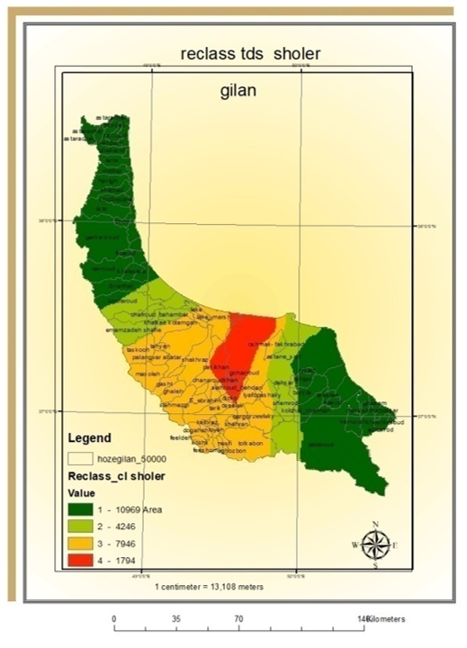
Figure 1. Influential Elements
Table 1. Area of Critical Zones in the Map of Influential Elements and Groundwater for Drinking in Gilan Province
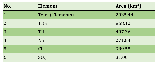
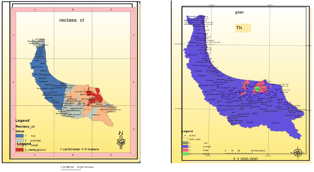
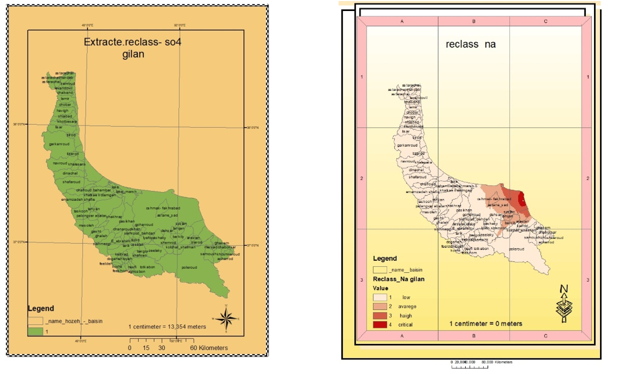
Figure 2. Composite Maps of Influential Elements
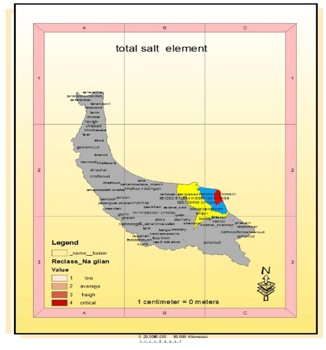
Figure 3. Drinking Water Map of Gilan Province
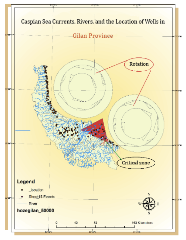
Figure 4. Caspian Sea Water Flow Map and Formation of the Triangular Zone
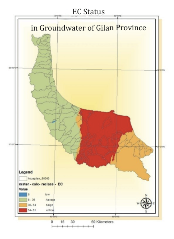
Figure 5. EC Distribution in Groundwater of Gilan
According to the Herzberg equation, seawater intrusion was confirmed as a finger-like pattern (Figure 6), and the thickness of the saline-freshwater interface was determined using the EC-depth curve. Reduced Caspian Sea water density along the eastern coast and excessive groundwater extraction may increase seawater intrusion up to 100 meters. Vorwijc’s relationship also indicated that primary alluvial cones contain freshwater, while the clayey regions of Chaf and Chamkhaleh are prone to salinity.
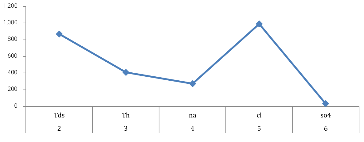
Figure 6. Area of Critical Zones in the Map of Influential Elements and the Drinking Water Map of Gilan Province
Main Comparisons to Similar Studies
The present study aligns with previous research, showing that groundwater salinity is influenced by irrigation water quality [Kamali-Muskan & Afzali, 2019], geological characteristics [Piran Qarni Namin et al., 2018], and climate change [El Assaoui et al., 2021]. Seawater intrusion in coastal aquifers and the mitigating role of subsurface barriers have been demonstrated [Karami Khaniki & Gharib Reza, 2005], with emphasis on predicting aquifer futures for sustainable management [Jamei & Ghafouri, 2008]. Related studies highlight that the combination of chemical elements and EC can delineate critical zones [Ahmadpour et al., 2010; Rezaei et al., 2010; Isazadeh et al., 2017]. Seawater intrusion, over-extraction, and reduced saline water density pose serious threats to coastal areas and agriculture [Colombani et al., 2016; Zou et al., 2016]. Continuous monitoring and management are essential to prevent further seawater penetration [Nematollahi et al., 2018].
Suggestions
It is recommended that surface and groundwater in the plain areas be controlled and optimally used to prevent flow toward the sea, which would reduce seawater density and salinity. Measures should also prevent contamination and excessive concentration of groundwater to avoid homogenization with seawater, thus maintaining boundaries and minimizing crises. However, due to the lack of comprehensive management and engineering programs, this crisis is increasing.
Conclusion
Seawater intrusion into aquifers is more pronounced in certain sections. The most influential factors on aquifer salinity include total dissolved solids, total hardness, and calcium, sodium, and sulfate ions. ُhe most critical zones are located in eastern Gilan and along the province’s eastern coasts.
Acknowledgments: I would like to express my sincere gratitude to Dr. Papoli, my esteemed professor, for guiding and advising me throughout this work.
Ethical Permission: Not applicable.
Conflict of Interest: None declared.
Author Contributions: Jalal Behzadi carried out all aspects of the manuscript (100%).
Funding: This research was conducted at the author’s own expense and received no financial support.
Seawater intrusion into coastal aquifers is a global and escalating challenge. Increased groundwater extraction and climate change exacerbate salinity and reduce the quality of freshwater resources. Various studies have shown that sea-level rise, decreased precipitation, declining groundwater levels, and geological characteristics contribute to this phenomenon and can threaten the sustainability of water resources and agriculture. Given the difficulty of delineating the boundary between groundwater and seawater in some coastal areas, accurately determining the status and boundaries of these resources has become increasingly important.
Previous Studies
Numerous studies have investigated seawater intrusion, salinity, and the impacts of climate change on groundwater resources. Numerical simulations have demonstrated that constructing subsurface barriers can prevent seawater intrusion [Karami Khaniki & Gharib Reza, 2005]. The significance of hydraulic conductivity in seawater advancement in coastal aquifers has been emphasized [Navari & Ataei Ashtiani, 2006], and reductions in hydrostatic pressure can cause saline water to rise into upper layers [Jahanshahi et al., 2007]. Two-dimensional modeling of salinity contour lines has also been proposed for sustainable management [Jamei & Ghafouri, 2008]. In Gilan Province, increases in electrical conductivity (EC) and salinity have been reported as threats to agriculture, particularly rice cultivation [Ahmadpour et al., 2010; Rezaei et al., 2010]. Several studies have indicated a decreasing trend in groundwater levels under climate change [Khayyat et al., 2012; Jafarzadeh et al., 2019; Ansarifar et al., 2019; Zeydalinejad et al., 2020]. The role of sea-level rise in exacerbating coastal water salinity has also been highlighted [Colombani et al., 2016].
Aim(s)
The aim of this study is to determine the status of groundwater relative to seawater.
Research Type
The present study was applied research.
Research Society, Place, and Time
The study population consisted of isometric groundwater wells in Gilan Province. The study was conducted in four sub-basins of Gilan Province, including the eastern, western, central, and southern highlands (Loushan–Manjil), using data from a 20-year period (2002–2022).
Sampling Method and Number
Census sampling was employed, with groundwater samples collected from all 127 isometric wells across the four sub-basins of Gilan Province.
Used Devices & Materials
Groundwater samples from 127 isometric wells were collected and analyzed for hydrogeochemical properties. Studied parameters included total dissolved solids (TDS), total hardness (TH), and electrical conductivity (EC). Spatial data analysis was performed using GIS software with Kriging and IDW interpolation methods. Empirical formulas by Herzberg and Vorwijc were also applied to describe seawater advancement.
Findings
Based on ranking and interpolation of groundwater quality elements, four categories from low to critical were determined, and the area of critical zones for each element was estimated (Figure 1). The largest critical area was related to Cl (989.55 km²) and the smallest to SO₄ (~31 km²). By merging all maps, the total critical area was 2035.44 km², mainly concentrated in the eastern coastal regions of Gilan (Table 1; Figure 2).
The drinking water map (Figure 3) and Caspian Sea flow map with the critical triangular zone (Figure 4) showed that EC critical areas overlap with the composite element map. EC distribution (Figure 5) closely corresponded to salinity lines, with the highest correlation observed between TDS and EC. The map of critical areas between element and drinking water maps was produced (Figure 6).
Figure 1. Influential Elements
Table 1. Area of Critical Zones in the Map of Influential Elements and Groundwater for Drinking in Gilan Province
Figure 2. Composite Maps of Influential Elements
Figure 3. Drinking Water Map of Gilan Province
Figure 4. Caspian Sea Water Flow Map and Formation of the Triangular Zone
Figure 5. EC Distribution in Groundwater of Gilan
According to the Herzberg equation, seawater intrusion was confirmed as a finger-like pattern (Figure 6), and the thickness of the saline-freshwater interface was determined using the EC-depth curve. Reduced Caspian Sea water density along the eastern coast and excessive groundwater extraction may increase seawater intrusion up to 100 meters. Vorwijc’s relationship also indicated that primary alluvial cones contain freshwater, while the clayey regions of Chaf and Chamkhaleh are prone to salinity.
Figure 6. Area of Critical Zones in the Map of Influential Elements and the Drinking Water Map of Gilan Province
Main Comparisons to Similar Studies
The present study aligns with previous research, showing that groundwater salinity is influenced by irrigation water quality [Kamali-Muskan & Afzali, 2019], geological characteristics [Piran Qarni Namin et al., 2018], and climate change [El Assaoui et al., 2021]. Seawater intrusion in coastal aquifers and the mitigating role of subsurface barriers have been demonstrated [Karami Khaniki & Gharib Reza, 2005], with emphasis on predicting aquifer futures for sustainable management [Jamei & Ghafouri, 2008]. Related studies highlight that the combination of chemical elements and EC can delineate critical zones [Ahmadpour et al., 2010; Rezaei et al., 2010; Isazadeh et al., 2017]. Seawater intrusion, over-extraction, and reduced saline water density pose serious threats to coastal areas and agriculture [Colombani et al., 2016; Zou et al., 2016]. Continuous monitoring and management are essential to prevent further seawater penetration [Nematollahi et al., 2018].
Suggestions
It is recommended that surface and groundwater in the plain areas be controlled and optimally used to prevent flow toward the sea, which would reduce seawater density and salinity. Measures should also prevent contamination and excessive concentration of groundwater to avoid homogenization with seawater, thus maintaining boundaries and minimizing crises. However, due to the lack of comprehensive management and engineering programs, this crisis is increasing.
Conclusion
Seawater intrusion into aquifers is more pronounced in certain sections. The most influential factors on aquifer salinity include total dissolved solids, total hardness, and calcium, sodium, and sulfate ions. ُhe most critical zones are located in eastern Gilan and along the province’s eastern coasts.
Acknowledgments: I would like to express my sincere gratitude to Dr. Papoli, my esteemed professor, for guiding and advising me throughout this work.
Ethical Permission: Not applicable.
Conflict of Interest: None declared.
Author Contributions: Jalal Behzadi carried out all aspects of the manuscript (100%).
Funding: This research was conducted at the author’s own expense and received no financial support.
References
1. Ahmadpour H, Khaledian MR, Ashrafzadeh A, Rezaei M (2010). Investigation of groundwater salinity in Guilan province in terms of agricultural uses with respect to electrical conductivity (EC) and two parameters effective salinity (ES) and potential salinity. Water and Soil Journal. 5(24):932-941. [Persian] [Link]
2. Ansarifar MM, Salarijazi M, Ghorbani K, Kaboli AR (2019). The impact of climate change on the content and spatial distribution of the total dissolved solids in Bandar-e-Gaz coastal aquifer. Geography and Environmental Sustainability. 9(31):83-95. [Persian] [Link]
3. Chui APY, Ang P Jr (2017). High tolerance to temperature and salinity change should enable scleractinian coral Platygyra acuta from marginal environments to persist under future climate change. PLoS One. 12(6):e0179423. [Link] [DOI:10.1371/journal.pone.0179423]
4. Colombani N, Osti A, Volta G, Mastrocicco M (2016). Impact of climate change on salinization of coastal water resources. Water Resources Management. 30(7):2483-2496. [Link] [DOI:10.1007/s11269-016-1292-z]
5. Edet A, Nganje TN, Ukpong AJ, Ekwere AS (2011). Groundwater chemistry and quality of Nigeria: A status review. African Journal of Environmental Science and Technology. 5(13):1152-1169. [Link] [DOI:10.5897/AJESTX11.009]
6. El Assaoui N, Sadok A, Merimi I (2021). Impacts of climate change on Moroccan's groundwater resources: State of art and development prospects. Materialstoday. 45(8):7690-7696. [Link] [DOI:10.1016/j.matpr.2021.03.220]
7. Halabian AH, Khneifer Z (2016). Investigating the effect of precipitation fluctuations on the discharge of the Plasjan River (case study: Eskandari Station). Proceedings of the 2nd National Conference on Geography and Planning, Architecture and Modern Urbanism. Qom: CIVILICA. [Persian] [Link]
8. Isazadeh M, Biazar SM, Ashrafzadeh A (2017). Support vector machines and feed-forward neural networks for spatial modeling of groundwater qualitative parameters. Environmental Earth Sciences. 76(17):610. [Link] [DOI:10.1007/s12665-017-6938-5]
9. Jafarzadeh A, Khashaei-Siouki A, Shahidi A (2019). Impact assessment of climate change on groundwater table using of balance conceptual model (Case study: Birjand Plain). Water Resources Engineering. 12(41):1-16. [Persian] [Link]
10. Jahanshahi R, Zare M, Raisi E (2007). Management of exploitation of the southeastern coastal aquifer of Maharloo Lake in order to prevent salinization of pumping wells (groundwater). Proceedings of the 5th Iranian Conference of Engineering Geology and the Environment. Tehran: CIVILICA. [Persian] [Link]
11. Jamei M, Ghafouri HR (2008). Modeling saltwater intrusion to evaluate water resources management methods in coastal aquifers. Proceedings of the 3rd Iran Water Resources Management Conference. Tabriz: CIVILICA. [Persian] [Link]
12. Kamali-Muskan E, Afzali SF (2019). Effect of irrigation with different salinities on some soil characteristics and salt concentration factor (Case study: Bighard, Khonj). Journal of Environmental Science and Technology. 21(4):141-152. [Persian] [Link]
13. Karami Khaniki A, Gharib Reza MR (2005). Reclamation and restoration of deltaic lands using tidal dams (case study of Zohreh River Delta). Proceedings of the 3rd Erosion and Sediment National Conference. Tehran: CIVILICA. [Persian] [Link]
14. Khayyat A, Amirabadizadeh M, Pourreza Bailandi M, Khozeimenejad H (2012). Prediction of groundwater level in Birjand plain using neural-fuzzy network under the influence of climate change. Journal of Aquifer and Qanat. 2(1):38-51. [Persian] [Link]
15. Le TDH, Kattwinkel M, Schützenmeister K, Olson JR, Hawkins CP, Schäfer RB (2018). Predicting current and future background ion concentrations in German surface water under climate change. Philosophical Transactions of the Royal Society B. 374(1764):20180004. [Link] [DOI:10.1098/rstb.2018.0004]
16. Mazandaranizadeh H, Zavash Pargo R, Daneshkar-Arasateh P (2019). Optimization of drainage design parameters with the aim of reducing environmental damage in steady-state conditions. Journal of Environmental Science and Technology. 21(6):155-165. [Persian] [Link]
17. Mengistu D, Bewket W, Dosio A, Panitz HJ (2021). Climate change impacts on water resources in the Upper Blue Nile (Abay) River Basin, Ethiopia. Journal of Hydrology. 592:125614. [Link] [DOI:10.1016/j.jhydrol.2020.125614]
18. Navari M, Ataei Ashtiani B (2006). Studying the effect of rising sea levels on saltwater intrusion in coastal aquifers: A case study of the Babol Hall aquifer in Haraz. Proceedings of the 7th International Conference on Coasts, Ports and Marine Structures. Tehran: CIVILICA. [Persian] [Link]
19. Nematollahi MJ, Clark MJR, Ebrahimi P, Ebrahimi M (2018). Preliminary assessment of groundwater hydrogeochemistry within Gilan, a northern province of Iran. Environmental Monitoring and Assessment. 190(4):242. [Link] [DOI:10.1007/s10661-018-6543-4]
20. Piran Qarni Namin S, Javid AH, Ghodousi J (2018). Effect of geological formation on the quality of groundwater (Case study: Ardebil Plain). Journal of Environmental Science and Technology. 20(3):1-10. [Persian] [Link]
21. Rezaei M, Davatgar N, Tajdari K, Abolpour B (2010). Investigation the spatial variability of som important groundwater quality factors in Guilan, Iran. Water an Soil Journal. 24(5): 465-487. [Link]
22. Seif A, Moridi A, Khazaiepool A (2018). Studying the impact of climate change on the discharge of the Kashf Rud River Basin and the supply of drinking water in Mashhad. Proceedings of the 1st Conference on the Use of Soil and Water Management Tools (SWAT) in the Management of the Country's Water Resources. Isfahan: CIVILICA. [Persian] [Link]
23. Sharma DA, Rishi MS, Keesari T (2017). Evaluation of groundwater quality and suitability for irrigation and drinking purposes in southwest Punjab, India using hydrochemical approach. Applied Water Science. 7(6):3137-3150. [Link] [DOI:10.1007/s13201-016-0456-6]
24. Suarez DL (1989). Impact of agricultural practices on groundwater salinity. Agriculture, Ecosystems & Environment. 26(3-4):215-227. [Link] [DOI:10.1016/0167-8809(89)90014-5]
25. Volodina IV, Sokolova TA (2007). Changes in the salt status of meadow-chestnut soils under the impact of saline groundwater in a model experiment. Eurasian Soil Science. 40(8):839-849. [Link] [DOI:10.1134/S1064229307080054]
26. Zeinali B, Asghari-Saraskanroud S (2012). The investigation of coastline changes in Urmia Lake water level and its impact on the urban of its basin. Urban Ecology Researches. 3(6):103-116. [Persian] [Link]
27. Zeydalinejad N, Nassery HR, Shakiba AR, Alijani F (2020). Simulation of karst aquifer water level under climate change in Lali region, Khouzestan province, SW Iran. Nivar. 44(108-109):102-114. [Persian] [Link]
28. Zou Z, Xiao X, Dong J, Qin Y, Doughty RB, Menarguez MA, et al (2018). Divergent trends of open-surface water body area in the contiguous United States from 1984 to 2016. Proceedings of the National Academy of Sciences. 115(15):3810-3815. [Link] [DOI:10.1073/pnas.1719275115]