
Bilingual
En/Fa
Geographical Research is Published in both Persian and English Full-text.
Volume 39, Issue 2 (2024)
GeoRes 2024, 39(2): 149-159 |
Back to browse issues page
Article Type:
Subject:


History
Received: 2024/03/18 | Accepted: 2024/05/7 | Published: 2024/05/20
Received: 2024/03/18 | Accepted: 2024/05/7 | Published: 2024/05/20
How to cite this article
Mehrabi A, Karimi S, Mohammadi Lahijani A. Monitoring of the Rafsanjan City Subsidence and Its Possible Causes. GeoRes 2024; 39 (2) :149-159
URL: http://georesearch.ir/article-1-1603-en.html
URL: http://georesearch.ir/article-1-1603-en.html
Download citation:
BibTeX | RIS | EndNote | Medlars | ProCite | Reference Manager | RefWorks
Send citation to:


Rights and permissions
BibTeX | RIS | EndNote | Medlars | ProCite | Reference Manager | RefWorks
Send citation to:

1- Department of Geography and Urban Planning, Faculty of Literature, Shahid Bahonar University of Kerman, Kerman, Iran
Full-Text (HTML) (619 Views)
Background
Land subsidence is a growing environmental issue, primarily caused by human activities such as excessive groundwater extraction. It can also result from natural factors like fault activity. Conventional geodetic methods provide precise measurements but lack spatial coverage. Recent advances, such as radar interferometry, offer effective tools for monitoring subsidence over large areas. Numerous studies have confirmed a strong link between subsidence and groundwater level decline in various regions.
Previous Studies
Numerous studies have examined the phenomenon of land subsidence in relation to groundwater depletion and geological factors. Sharifikia (2012) has estimated an annual subsidence rate of up to 30 cm in the Noq-Bahreman plain. Ranjbar and Jafari (2009) identify evaporite formations and excessive groundwater withdrawal as key causes of subsidence in the Eshtehard plain. Nazmfar and Shirzad Khrjan (2022) report a subsidence rate of up to 35 cm/year in the Meshgin plain of Ardabil Province, attributing it to overextraction of groundwater. In Indonesia, Maghsoudi et al. (2018) documented a 4.6 mm/year subsidence rate in Java. Pawluszek-Filipiak and Borkowski (2021) have used Persistent Scatterer Interferometry to analyze mining-induced cumulative subsidence in Poland, finding a maximum rate of 10 cm/year. El Kamali et al. (2021) have investigated subsidence in Rimah, UAE, and reported a rate of 40 mm/year. These studies highlight the widespread and diverse nature of subsidence drivers and emphasize the importance of spatial-temporal analysis.
Aim(s)
The present study was conducted with the aim of monitoring land subsidence in the urban area of Rafsanjan and determining the extent and severity of subsidence within the city limits.
Research Type
The present study is applied in nature.
Research Society, Place and Time
This applied research was conducted in 2023 in Rafsanjan city, located in the northern part of Kerman Province, Iran. The region lies within a semi-arid climate zone with an average annual precipitation of 130 mm over the past 40 years. The research society includes groundwater resources and land monitoring in the Rafsanjan plain for analysis.
Sampling Method and Number
The sampling method involved targeted (purposive) sampling based on the location of groundwater wells within the Rafsanjan plain. A total of 40 groundwater samples were collected from selected wells to evaluate the relationship between groundwater extraction and land subsidence. The sample sites were chosen to represent areas potentially affected by overextraction and geological activity.
For spatial and temporal analysis of land subsidence, 73 Sentinel-1 images (VV polarization) from August 17, 2014, to April 23, 2022, and a 30-meter SRTM DEM were used. The presence of active faults and significant agricultural activity in the area were also considered in the study.
Used Devices & Materials
In this study, a combination of satellite data, digital models, field samples, and specialized software tools was used. A total of 73 Sentinel-1 SAR images with VV polarization, dated between August 17, 2014, and April 23, 2022, were employed for analyzing ground surface displacement through radar interferometry. Additionally, a 30-meter resolution SRTM digital elevation model (DEM) was used to correct topographic effects in the interferometric processing. To assess groundwater conditions, 40 water samples were collected from selected wells across the Rafsanjan plain using standard groundwater sampling tools. For data processing and analysis, SNAP software was used for SAR image preprocessing, StaMPS software was applied for time-series interferometric analysis using the Coherent Pixel Technique (CPT), and ArcGIS 10.3 was used for mapping, spatial analysis, and visualizing coherence and deformation results. Together, these materials and tools enabled a comprehensive assessment of land subsidence and its relation to groundwater exploitation in the study area.
Findings by Text
Based on the processing of Sentinel-1 imagery using the CPT technique, ground surface displacement in the Rafsanjan plain was analyzed from 2014 to 2022. During this period, the maximum rate of land subsidence in the central areas of the plain reached up to -13 cm per year, and the extent of the affected area increased from 1,200 to 1,300 square kilometers (Figure 1). It was also observed that the subsidence gradually expanded into the urban area of Rafsanjan from the north and east (Figure 2).
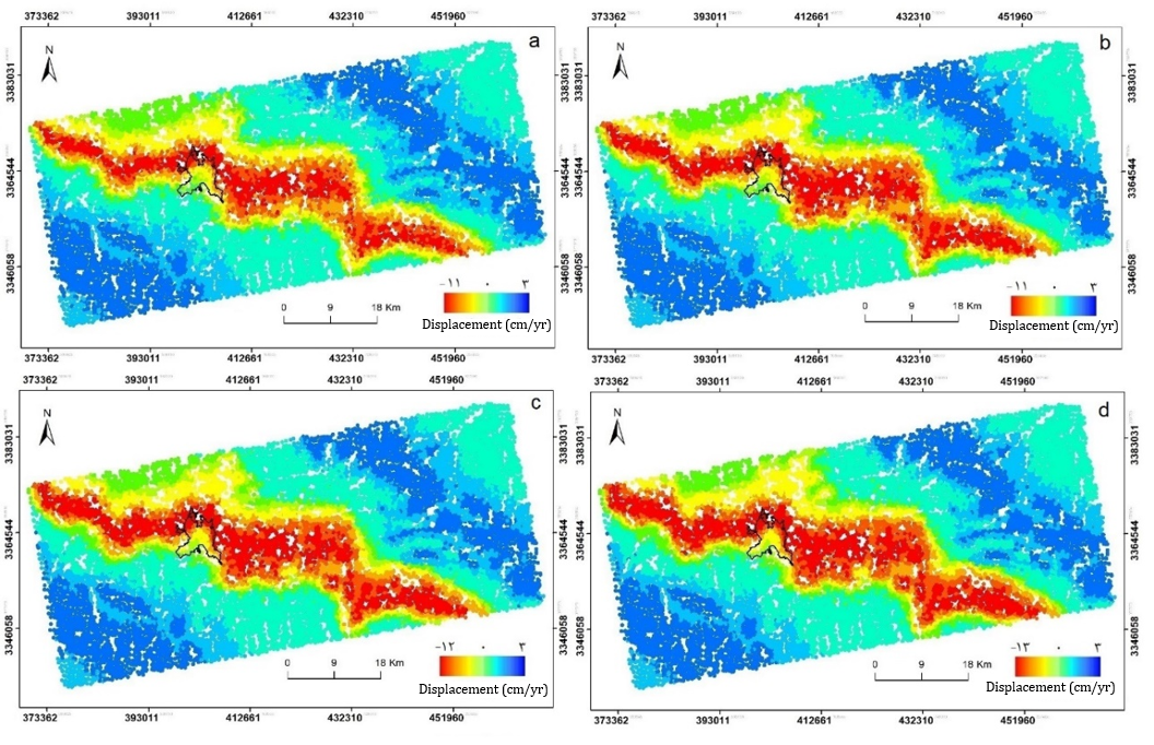
Figure 1. Map of surface changes in the Rafsanjan plain for the time periods of a: 2014–2016 b: 2016–2018 c: 2018–2020 d: 2020–2022
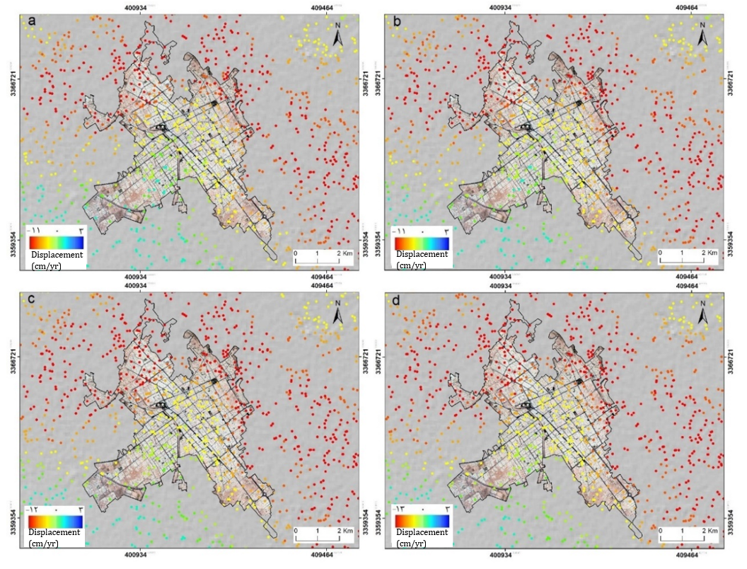
Figure 2) Map of displacement in the Rafsanjan city area for the time periods: a: 2014–2016 b: 2016–2018 c: 2018–2020 d: 2020–2022 (The location of the Nouq Fault is indicated by a red line.)
For data validation, the CPT results were compared with GPS observations from the National Cartographic Center station in Rafsanjan, showing a good match with a root mean square error (RMSE) of 0.136 mm (Figure 3).
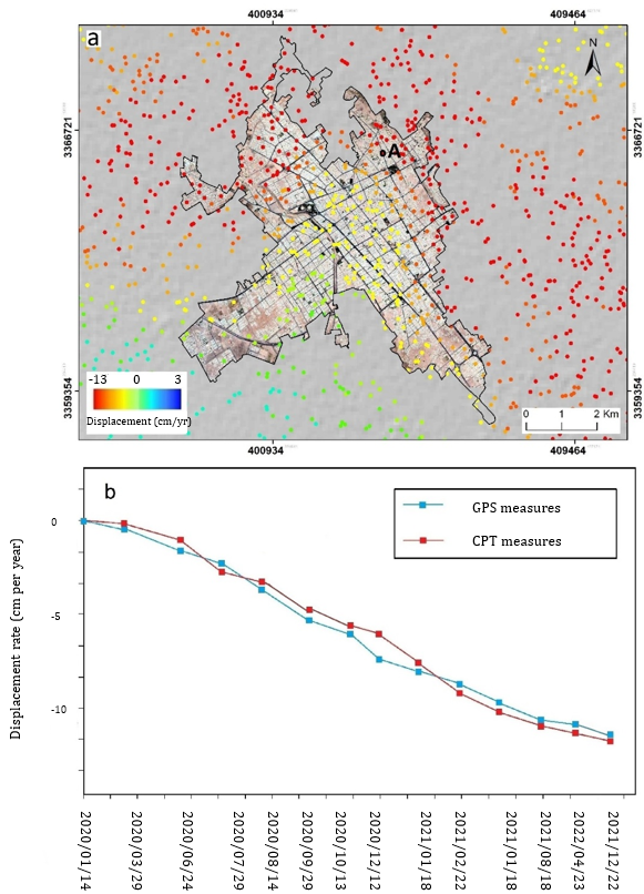
Figure 3. Validation of the displacement map
Analysis of groundwater data from 40 wells revealed that in some parts of the study area, the water table declined by an average of 2 meters per year. The greatest decline occurred in the central and western parts of the plain, while slight uplifts were recorded in some areas in the north and southwest (Figure 4).
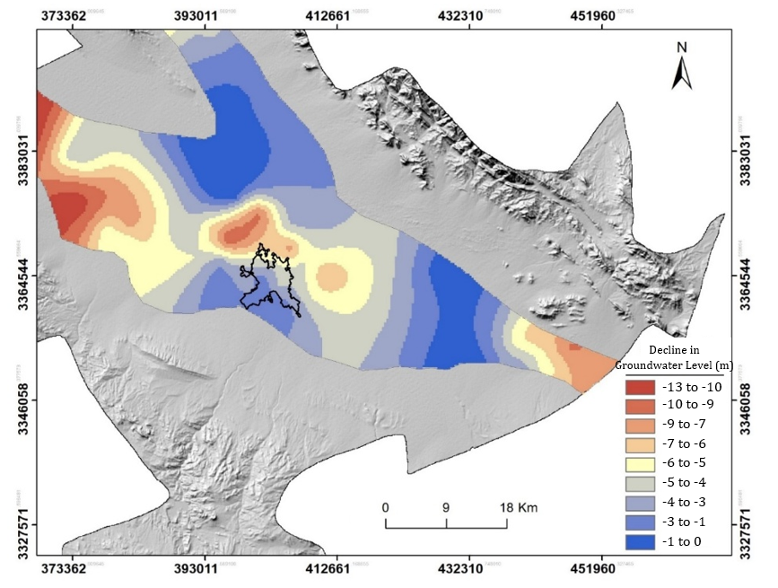
Figure 4. Map of groundwater level changes in the study area
The relationship between land subsidence and groundwater level decline was examined through map overlay analysis in a GIS environment. Results indicated that areas with high rates of subsidence largely overlapped with zones experiencing severe groundwater depletion (Figure 5).
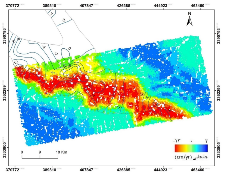
Figure 5. Relationship between land subsidence and groundwater level changes
Further analysis of the relationship between subsidence and faults using spatial correlation showed a strong association between the subsidence map and the location of active faults in the region (Figure 6). Closer investigation of the Nouq Fault revealed that it has a direct relationship with subsidence in the urban area of Rafsanjan (Figure 7). To better understand this, ground displacement cross-sections were plotted along two profiles perpendicular to the fault, confirming notable surface deformation along its path (Figure 8). Field evidence also confirmed the occurrence of linear subsidence within the city area.
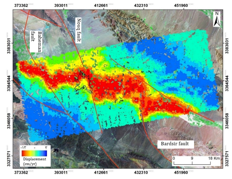
Figure 6. Overlay of the land subsidence map and faults in the study area
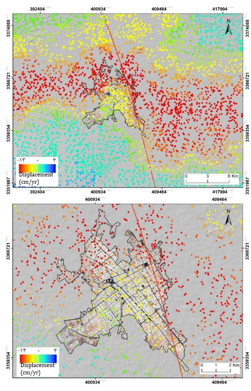
Figure 7. Relationship between land subsidence and the Nouq fault in the Rafsanjan urban area
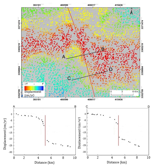
Figure 8) Displacement profile perpendicular to the Nouq fault
Main Comparisons to Similar Studies
The findings of this study are consistent with several similar investigations highlighting groundwater over-extraction as a primary driver of land subsidence in urban areas. As observed in Rafsanjan, the spatial overlap between zones of significant groundwater drawdown and areas of high subsidence rates supports the conclusions drawn by Hussain et al. (2022), Lo et al. (2022), Ghorbani et al. (2022), and Han et al. (2023), who also have emphasized overexploitation of aquifers as a dominant cause of subsidence. Additionally, the observed spatial correlation between subsidence patterns and fault lines, particularly the Nouq, Bahrman, and Bardsir faults, aligns with results from Cigna and Tapete (2021) and Zhang et al. (2023), who reported that geological structures like faults can control the geometry and extent of subsidence zones. The present study further supports this by showing a sharp deformation gradient across the Nouq fault, with field observations revealing linear surface cracks matching the fault’s azimuth, reinforcing the role of tectonic factors alongside groundwater depletion.
Suggestions
None is mentioned.
Conclusion
The urban area is experiencing progressive land subsidence that is gradually extending toward the inner and central parts of the city. Excessive groundwater extraction is one of the key contributing factors to the subsidence in Rafsanjan. The Nouq, Bahrman, and Bardsir faults play a controlling role in the subsidence of Rafsanjan Plain, with the Nouq fault specifically influencing the subsidence pattern within the urban area.
Acknowledgments: None reported by the authors.
Ethical Permission: None reported by the authors.
Conflict of Interest: None reported by the authors.
Authors’ Contributions: Mehrabi A (First author), Main Researcher (50%); Karimi S (Second author), Methodologist/Statistical Analyst (40%); Mohammadi Lahijani A (Third author), Statistical Analyst (10%).
Funding: None reported by the authors.
Land subsidence is a growing environmental issue, primarily caused by human activities such as excessive groundwater extraction. It can also result from natural factors like fault activity. Conventional geodetic methods provide precise measurements but lack spatial coverage. Recent advances, such as radar interferometry, offer effective tools for monitoring subsidence over large areas. Numerous studies have confirmed a strong link between subsidence and groundwater level decline in various regions.
Previous Studies
Numerous studies have examined the phenomenon of land subsidence in relation to groundwater depletion and geological factors. Sharifikia (2012) has estimated an annual subsidence rate of up to 30 cm in the Noq-Bahreman plain. Ranjbar and Jafari (2009) identify evaporite formations and excessive groundwater withdrawal as key causes of subsidence in the Eshtehard plain. Nazmfar and Shirzad Khrjan (2022) report a subsidence rate of up to 35 cm/year in the Meshgin plain of Ardabil Province, attributing it to overextraction of groundwater. In Indonesia, Maghsoudi et al. (2018) documented a 4.6 mm/year subsidence rate in Java. Pawluszek-Filipiak and Borkowski (2021) have used Persistent Scatterer Interferometry to analyze mining-induced cumulative subsidence in Poland, finding a maximum rate of 10 cm/year. El Kamali et al. (2021) have investigated subsidence in Rimah, UAE, and reported a rate of 40 mm/year. These studies highlight the widespread and diverse nature of subsidence drivers and emphasize the importance of spatial-temporal analysis.
Aim(s)
The present study was conducted with the aim of monitoring land subsidence in the urban area of Rafsanjan and determining the extent and severity of subsidence within the city limits.
Research Type
The present study is applied in nature.
Research Society, Place and Time
This applied research was conducted in 2023 in Rafsanjan city, located in the northern part of Kerman Province, Iran. The region lies within a semi-arid climate zone with an average annual precipitation of 130 mm over the past 40 years. The research society includes groundwater resources and land monitoring in the Rafsanjan plain for analysis.
Sampling Method and Number
The sampling method involved targeted (purposive) sampling based on the location of groundwater wells within the Rafsanjan plain. A total of 40 groundwater samples were collected from selected wells to evaluate the relationship between groundwater extraction and land subsidence. The sample sites were chosen to represent areas potentially affected by overextraction and geological activity.
For spatial and temporal analysis of land subsidence, 73 Sentinel-1 images (VV polarization) from August 17, 2014, to April 23, 2022, and a 30-meter SRTM DEM were used. The presence of active faults and significant agricultural activity in the area were also considered in the study.
Used Devices & Materials
In this study, a combination of satellite data, digital models, field samples, and specialized software tools was used. A total of 73 Sentinel-1 SAR images with VV polarization, dated between August 17, 2014, and April 23, 2022, were employed for analyzing ground surface displacement through radar interferometry. Additionally, a 30-meter resolution SRTM digital elevation model (DEM) was used to correct topographic effects in the interferometric processing. To assess groundwater conditions, 40 water samples were collected from selected wells across the Rafsanjan plain using standard groundwater sampling tools. For data processing and analysis, SNAP software was used for SAR image preprocessing, StaMPS software was applied for time-series interferometric analysis using the Coherent Pixel Technique (CPT), and ArcGIS 10.3 was used for mapping, spatial analysis, and visualizing coherence and deformation results. Together, these materials and tools enabled a comprehensive assessment of land subsidence and its relation to groundwater exploitation in the study area.
Findings by Text
Based on the processing of Sentinel-1 imagery using the CPT technique, ground surface displacement in the Rafsanjan plain was analyzed from 2014 to 2022. During this period, the maximum rate of land subsidence in the central areas of the plain reached up to -13 cm per year, and the extent of the affected area increased from 1,200 to 1,300 square kilometers (Figure 1). It was also observed that the subsidence gradually expanded into the urban area of Rafsanjan from the north and east (Figure 2).
Figure 1. Map of surface changes in the Rafsanjan plain for the time periods of a: 2014–2016 b: 2016–2018 c: 2018–2020 d: 2020–2022
Figure 2) Map of displacement in the Rafsanjan city area for the time periods: a: 2014–2016 b: 2016–2018 c: 2018–2020 d: 2020–2022 (The location of the Nouq Fault is indicated by a red line.)
For data validation, the CPT results were compared with GPS observations from the National Cartographic Center station in Rafsanjan, showing a good match with a root mean square error (RMSE) of 0.136 mm (Figure 3).
Figure 3. Validation of the displacement map
Analysis of groundwater data from 40 wells revealed that in some parts of the study area, the water table declined by an average of 2 meters per year. The greatest decline occurred in the central and western parts of the plain, while slight uplifts were recorded in some areas in the north and southwest (Figure 4).
Figure 4. Map of groundwater level changes in the study area
The relationship between land subsidence and groundwater level decline was examined through map overlay analysis in a GIS environment. Results indicated that areas with high rates of subsidence largely overlapped with zones experiencing severe groundwater depletion (Figure 5).
Figure 5. Relationship between land subsidence and groundwater level changes
Further analysis of the relationship between subsidence and faults using spatial correlation showed a strong association between the subsidence map and the location of active faults in the region (Figure 6). Closer investigation of the Nouq Fault revealed that it has a direct relationship with subsidence in the urban area of Rafsanjan (Figure 7). To better understand this, ground displacement cross-sections were plotted along two profiles perpendicular to the fault, confirming notable surface deformation along its path (Figure 8). Field evidence also confirmed the occurrence of linear subsidence within the city area.
Figure 6. Overlay of the land subsidence map and faults in the study area
Figure 7. Relationship between land subsidence and the Nouq fault in the Rafsanjan urban area
Figure 8) Displacement profile perpendicular to the Nouq fault
Main Comparisons to Similar Studies
The findings of this study are consistent with several similar investigations highlighting groundwater over-extraction as a primary driver of land subsidence in urban areas. As observed in Rafsanjan, the spatial overlap between zones of significant groundwater drawdown and areas of high subsidence rates supports the conclusions drawn by Hussain et al. (2022), Lo et al. (2022), Ghorbani et al. (2022), and Han et al. (2023), who also have emphasized overexploitation of aquifers as a dominant cause of subsidence. Additionally, the observed spatial correlation between subsidence patterns and fault lines, particularly the Nouq, Bahrman, and Bardsir faults, aligns with results from Cigna and Tapete (2021) and Zhang et al. (2023), who reported that geological structures like faults can control the geometry and extent of subsidence zones. The present study further supports this by showing a sharp deformation gradient across the Nouq fault, with field observations revealing linear surface cracks matching the fault’s azimuth, reinforcing the role of tectonic factors alongside groundwater depletion.
Suggestions
None is mentioned.
Conclusion
The urban area is experiencing progressive land subsidence that is gradually extending toward the inner and central parts of the city. Excessive groundwater extraction is one of the key contributing factors to the subsidence in Rafsanjan. The Nouq, Bahrman, and Bardsir faults play a controlling role in the subsidence of Rafsanjan Plain, with the Nouq fault specifically influencing the subsidence pattern within the urban area.
Acknowledgments: None reported by the authors.
Ethical Permission: None reported by the authors.
Conflict of Interest: None reported by the authors.
Authors’ Contributions: Mehrabi A (First author), Main Researcher (50%); Karimi S (Second author), Methodologist/Statistical Analyst (40%); Mohammadi Lahijani A (Third author), Statistical Analyst (10%).
Funding: None reported by the authors.
Keywords:
References
1. Azarakhsh Z, Azadbakht M, Matkan A (2022). Estimation, modeling, and prediction of land subsidence using Sentinel-1 time series in Tehran-Shahriar plain: A machine learning-based investigation. Remote Sensing Applications: Society and Environment. 25:100691. [Link] [DOI:10.1016/j.rsase.2021.100691]
2. Blanco-Sánchez P, Mallorquí JJ, Duque S, Monells D (2008). The Coherent Pixels Technique (CPT): An advanced DInSAR technique for nonlinear deformation monitoring. Pure and Applied Geophysics. 165(6):1167-1193. [Link] [DOI:10.1007/s00024-008-0352-6]
3. Cigna F, Tapete D (2021). Present-day land subsidence rates, surface faulting hazard and risk in Mexico City with 2014-2020 Sentinel-1 IW InSAR. Remote Sensing of Environment. 253:112161. [Link] [DOI:10.1016/j.rse.2020.112161]
4. Duque S, Mallorqui JJ, Blanco P, Monells D (2007). Application of the Coherent Pixels Technique (CPT) to urban monitoring. Proceedings of the 2007 Urban Remote Sensing Joint Event. Paris: IEEE. [Link] [DOI:10.1109/URS.2007.371880]
5. El Kamali M, Papoutsis I, Loupasakis C, Abuelgasim A, Omari K, Kontoes C (2021). Monitoring of land surface subsidence using persistent scatterer interferometry techniques and ground truth data in arid and semi-arid regions, the case of Remah, UAE. Science of the Total Environment. 776:145946. [Link] [DOI:10.1016/j.scitotenv.2021.145946]
6. Ghorbani Z, Khosravi A, Maghsoudi Y, Mojtahedi FF, Javadnia E, Nazari A (2022). Use of InSAR data for measuring land subsidence induced by groundwater withdrawal and climate change in Ardabil Plain, Iran. Scientific Reports. 12(1):13998. [Link] [DOI:10.1038/s41598-022-17438-y]
7. Han Y, Liu G, Liu J, Yang J, Xie X, Yan W, et al (2023). Monitoring and analysis of land subsidence in Jiaozuo City (China) based on SBAS-InSAR Technology. Sustainability. 15(15):11737. [Link] [DOI:10.3390/su151511737]
8. Hussain MA, Chen Z, Zheng Y, Shoaib M, Ma J, Ahmad I, et al (2022). PS-InSAR based monitoring of land subsidence by groundwater extraction for Lahore Metropolitan City, Pakistan. Remote Sensing. 14(16):3950. [Link] [DOI:10.3390/rs14163950]
9. Lo W, Purnomo SN, Dewanto BG, Sarah D, Sumiyanto (2022). Integration of numerical models and InSAR techniques to assess land subsidence due to excessive groundwater abstraction in the Coastal and Lowland regions of Semarang City. Water. 14(2):201. [Link] [DOI:10.3390/w14020201]
10. Maghsoudi Y, Meer F, Hecker C, Perissin D, Saepuloh A (2018). Using PS-InSAR to detect surface deformation in geothermal areas of West Java in Indonesia. International Journal of Applied Earth Observation and Geoinformation. 64:386-396. [Link] [DOI:10.1016/j.jag.2017.04.001]
11. Mahmoodinasab F, Mohseni N (2021). A spatiotemporal analysis of the relationship between groundwater level and ground surface displacement using Sentinel-1 SAR data. Arabian Journal of Geosciences. 14(12):1106. [Link] [DOI:10.1007/s12517-021-07497-2]
12. Navarro-Hernández MI, Tomás R, Lopez-Sanchez JM, Cárdenas-Tristán A, Mallorquí JJ (2020). Spatial analysis of land subsidence in the San Luis Potosi Valley induced by aquifer overexploitation using the Coherent Pixels Technique (CPT) and Sentinel-1 InSAR observation. Remote Sensing. 12(22):3822. [Link] [DOI:10.3390/rs12223822]
13. Nazmfar H, Shirzad Khrjan M (2022). Surface subsidence monitoring with radar interference technique (study area: Meshgin plain). Journal of Natural Environment Hazards. 11(31):25-48. [Persian] [Link]
14. Pawluszek-Filipiak K, Borkowski A (2021). Monitoring mining-induced subsidence by integrating differential radar interferometry and persistent scatterer techniques. European Journal of Remote Sensing. 54(Suppl 1):18-30. [Link] [DOI:10.1080/22797254.2020.1759455]
15. Ramirez RA, Kwon TH (2022). Sentinel-1 persistent scatterer interferometric synthetic aperture radar (PS-InSAR) for long-term remote monitoring of ground subsidence: A case study of a port in Busan, South Korea. KSCE Journal of Civil Engineering. 26(10):4317-4329. [Link] [DOI:10.1007/s12205-022-1005-5]
16. Ranjbar M, Jafari N (2009). Investigating the effective factors in the subsidence of the Eshtehard plain. Journal of Geography. 6(19):155-166. [Persian] [Link]
17. Rashidi A, Khatib MM, Mousavi SM, Jamour Y (2017). Estimation of the location of active faults in the south and west of Lut Block. Geosciences. 26(104):211-222. [Persian] [Link]
18. Salehi R, Ghafoori M, Lashkaripour GR, Dehghani M (2013). Evaluation of land subsidence in southern Mahyar Plain using radar interferometry. Journal of Irrigation and Water Engineering. 3(3):47-57. [Persian] [Link]
19. Sharifikia M (2012). Determining the amount and range of land subsidence using radar interferometric method in Noug-Bahrman Plain. Journal of Spatial Planning. 16(3):55-77. [Persian] [Link]
20. Verberne M, Koster K, Lourens A, Gunnink J, Candela T, Fokker A (2023). Disentangling shallow subsidence sources by data assimilation in a reclaimed urbanized coastal plain, South Flevoland polder, the Netherlands. JGR Earth Surface. 128(7):e2022JF007031. [Link] [DOI:10.1029/2022JF007031]
21. Xu X, Zhou C, Gong H, Chen B, Wang L (2023). Monitoring and analysis of land subsidence in Cangzhou based on small baseline subsets interferometric point target analysis technology. Land. 12(12):2114. [Link] [DOI:10.3390/land12122114]
22. Yuan M, Li M, Liu H, Lv P, Li B, Zheng W (2021). Subsidence monitoring base on SBAS-InSAR and slope stability analysis method for damage analysis in mountainous mining subsidence regions. Remote Sensing. 13(16):3107. [Link] [DOI:10.3390/rs13163107]
23. Zhang Z, Hu C, Wu Z, Zhang Z, Yang S, Yang W (2023). Monitoring and analysis of ground subsidence in Shanghai based on PS-InSAR and SBAS-InSAR technologies. Scientific Reports. 13(1):8031. [Link] [DOI:10.1038/s41598-023-35152-1]