
Bilingual
En/Fa
Geographical Research is Published in both Persian and English Full-text.
Volume 39, Issue 2 (2024)
GeoRes 2024, 39(2): 161-168 |
Back to browse issues page
Article Type:
Subject:


History
Received: 2024/02/10 | Accepted: 2024/04/17 | Published: 2024/04/28
Received: 2024/02/10 | Accepted: 2024/04/17 | Published: 2024/04/28
How to cite this article
Tavakkoli M, Amirahmadi A, Goli Mokhtari L. Evaluation, Prediction and Regional Analysis of Floods Using Data Mining Models (Frizi Watershed). GeoRes 2024; 39 (2) :161-168
URL: http://georesearch.ir/article-1-1585-en.html
URL: http://georesearch.ir/article-1-1585-en.html
Download citation:
BibTeX | RIS | EndNote | Medlars | ProCite | Reference Manager | RefWorks
Send citation to:


Rights and permissions
BibTeX | RIS | EndNote | Medlars | ProCite | Reference Manager | RefWorks
Send citation to:

1- Department of Climatology and Geomorphology, Faculty of Geography and Environmental Science, Hakim Sabzevari University, Sabzevar, Iran
Full-Text (HTML) (297 Views)
Background
Flooding is one of the most devastating natural hazards, causing widespread human, financial, and environmental losses. In Iran, due to its climatic conditions and uneven rainfall distribution, floods are common, yet effective management has received limited attention. One efficient method to reduce flood risk is hazard zoning using predictive models such as Artificial Neural Networks (ANN) and Support Vector Machines (SVM), whose effectiveness has been confirmed in various studies.
Previous Studies
Various methods have been used in previous studies to predict and zone flood hazards. Shahabi (2021) employed ANN, Frequency Ratio, and Certainty Factor models to assess flood risk in the Haraz watershed and found them to be reliable. Zangeneh Asadi et al. (2021) applied L-THIA, VIKOR, and ANN models in Khorasan Razavi Province, showing that the L-THIA model had higher accuracy. Bakhtiar et al. (2022) also reported the high efficiency of ANN in predicting flood potential in the Kan watershed. Ahmad et al. (2022) in France and Sarigöl et al. (2022) in Turkey confirmed the successful performance of ANN and SVM models. Salavati et al. (2023) identified flood-influencing factors in Tehran using SVR and parameter optimization. These studies collectively emphasize the important role of intelligent models in flood risk management.
Aim(s)
This study was conducted with the aim of identifying flood hazard zones in the Farizi watershed using the Artificial Neural Network (ANN) and Support Vector Machine (SVM) models. By identifying the factors influencing flood occurrence in the region, the necessary measures for control, planning, and protective and management actions to reduce flood risk can be undertaken.
Research Type
This research was applied, analytical, and developmental in nature.
Research Society, Place and Time
The study was conducted in 2023 in the Farizi watershed, located in the southwest of Chenaran County, within the Kashafrud basin in Khorasan Razavi Province. The study area includes flood-prone regions spanning 80.572 km², analyzed to assess flood risk and generate hazard zoning maps using machine learning models.
Sampling Method and Number
A supervised learning method was employed. A total of 150 flood-prone points were identified using Landsat 8 satellite imagery and Google Earth. Of these, 70% (105 points) were used for model training and 30% (45 points) for validation.
Used Devices & Materials
Various maps, satellite images, and specialized software were used for data collection, processing, and analysis. These included topographic (1:50,000), geological (1:100,000), soil (1:50,000), and land use (1:25,000) maps; 30-year rainfall data (1991–2021); a 12.5-meter resolution Digital Elevation Model (DEM); and contour lines to generate a geomorphological map. Spatial data were derived from Landsat 8 imagery and Google Earth. For statistical analysis, modeling, and algorithm programming, ArcGIS 10.4, R Studio, MATLAB R2023a, SPSS 26, ENVI 5.3, and WinGammaTM 1.98 were utilized. These tools played a crucial role in flood hazard mapping and identifying key contributing factors.
Findings by Text
Findings revealed that several factors influenced flood occurrence in the study area: low-permeability resistant formations, elevation (with most flooding occurring between 0–1000 meters), shallow Alfisol soils, land use, and vegetation cover all contributed to increased runoff and flood potential. Springtime convective rainfall and high drainage density also played major roles. Gentle slopes and convex northern, northwestern, and western hillsides were flood-prone (Figure 2).
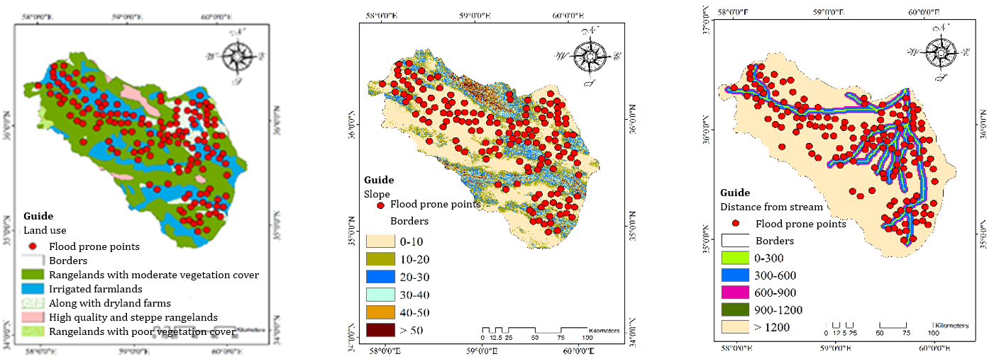
Figure 2. The most important factors influencing flood occurrence
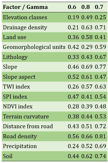
Gamma testing was used to identify the most influential variables on flood discharge (Table 1). ANN modeling of peak instantaneous discharges showed high accuracy, particularly for the 50-year return period (Table 2). The highest correlation between input layers and flood susceptibility maps was a gamma value of 0.8 (Table 3).
Table 1. Selection of effective parameters on flood discharge using the Gamma test
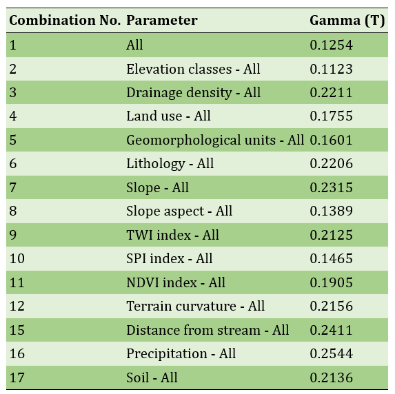
Table 2. Modeling results using Artificial Neural Network (ANN) in the training and testing phases
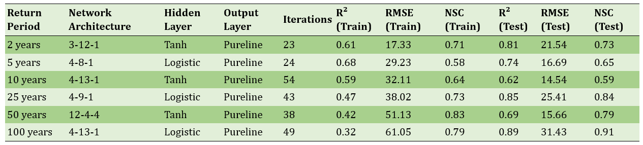
Table 3. Results of layer overlap with flood susceptibility zoning maps using Gamma index
For modeling with SVM and ANN algorithms, 150 flood-prone points were used (70% training, 30% validation). Accuracy assessment showed that the ANN model outperformed SVM (Table 4), a result supported by the ROC curve (Figure 3).
Table 4. Evaluation of training data modeling using SVM and ANNs algorithms
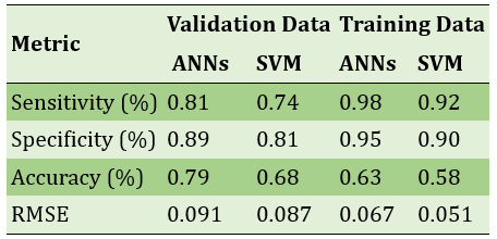
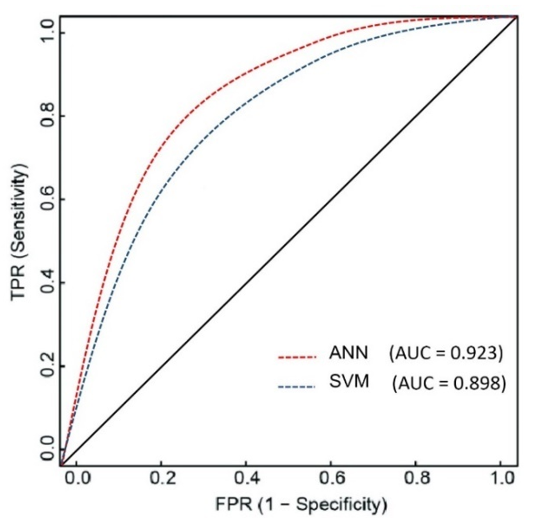
Figure 3. Validation of the applied models using the ROC method
Flood susceptibility maps revealed that 83% of the area fell within moderate to very high risk zones in the ANN model, compared to 75% in the SVM model (Figure 4).
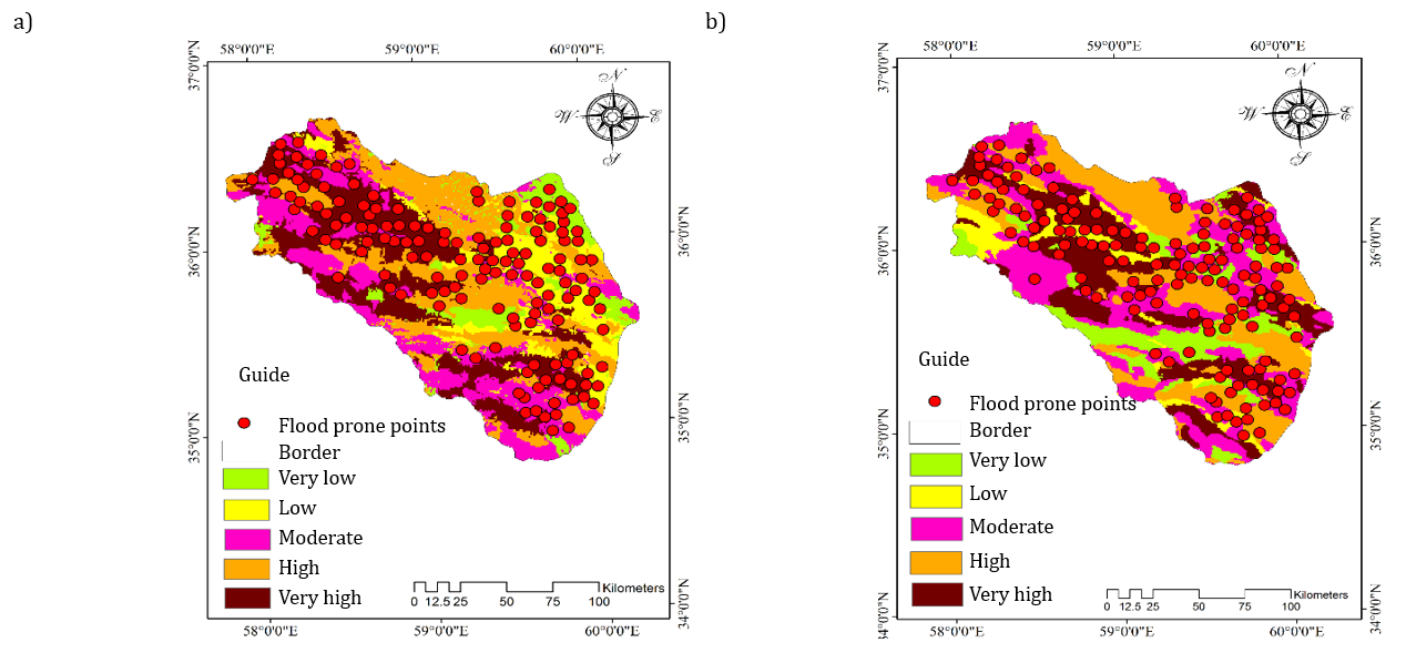
Figure 4. Flood zoning map: a) using the ANNs model, b) using the SVM model
Main Comparisons to Similar Studies
This study used ANN and SVM models to delineate flood hazard zones in the Farizi watershed and identify key contributing factors. Reduced vegetation cover and rangeland conversion to agricultural land, leading to lower infiltration and higher runoff, aligned with [Aristizábal et al., 2020]. The role of low slope and elevation in increasing runoff and flood risk was consistent with [Nhu et al., 2020; Chowdhuri et al., 2020]. The predominance of resistant geological formations and high drainage density, both increasing runoff, matched findings from [Khosravi et al., 2019; Pinos & Quesada-Román, 2022; Munawar et al., 2022; Peredo et al., 2022; Berghuijs et al., 2019]. Geomorphological impacts and the role of alluvial fans in flood susceptibility were consistent with [Al-Areeq et al., 2022], and the effect of steep slopes and snow retention with [Ceola et al., 2022]. The influence of precipitation, soil, and geology on flood discharge was in line with [Binh et al., 2020; Hatami Nejad et al., 2017; Hong et al., 2018]. The study concludes that watershed management and conservation measures are essential to reduce flood risk.
Suggestions
Given the flood-prone nature of the region, management and watershed conservation measures are imperative. These include producing flood hazard zoning maps, delineating river channel boundaries, and managing floodplain development. Watershed protection and reforestation activities can enhance infiltration and reduce flood potential. Construction in vulnerable zones, especially near riverbeds and foothills, should be avoided.
Conclusion
Flooding in the studied watershed predominantly occurs in areas with gentle slopes, resistant and impermeable geological formations, lower elevations and lands adjacent to river channels (floodplains). The zones classified as high and very high flood hazards are mainly concentrated in the central parts and outlets of the watershed.
Acknowledgments: None reported by the authors.
Ethical Permission: None reported by the authors.
Conflict of Interest: None reported by the authors.
Authors’ Contributions: Tavakkoli M (First author), Introduction Writer/Methodologist (30%); Amirahmadi A (Second author), Introduction Writer/ Statistical Analyst (40%); Goli Mokhtari L (Third author), Discussion Writer/Statistical Analyst (30%).
Funding: This study was conducted with the support of Hakim Sabzevari University.
Flooding is one of the most devastating natural hazards, causing widespread human, financial, and environmental losses. In Iran, due to its climatic conditions and uneven rainfall distribution, floods are common, yet effective management has received limited attention. One efficient method to reduce flood risk is hazard zoning using predictive models such as Artificial Neural Networks (ANN) and Support Vector Machines (SVM), whose effectiveness has been confirmed in various studies.
Previous Studies
Various methods have been used in previous studies to predict and zone flood hazards. Shahabi (2021) employed ANN, Frequency Ratio, and Certainty Factor models to assess flood risk in the Haraz watershed and found them to be reliable. Zangeneh Asadi et al. (2021) applied L-THIA, VIKOR, and ANN models in Khorasan Razavi Province, showing that the L-THIA model had higher accuracy. Bakhtiar et al. (2022) also reported the high efficiency of ANN in predicting flood potential in the Kan watershed. Ahmad et al. (2022) in France and Sarigöl et al. (2022) in Turkey confirmed the successful performance of ANN and SVM models. Salavati et al. (2023) identified flood-influencing factors in Tehran using SVR and parameter optimization. These studies collectively emphasize the important role of intelligent models in flood risk management.
Aim(s)
This study was conducted with the aim of identifying flood hazard zones in the Farizi watershed using the Artificial Neural Network (ANN) and Support Vector Machine (SVM) models. By identifying the factors influencing flood occurrence in the region, the necessary measures for control, planning, and protective and management actions to reduce flood risk can be undertaken.
Research Type
This research was applied, analytical, and developmental in nature.
Research Society, Place and Time
The study was conducted in 2023 in the Farizi watershed, located in the southwest of Chenaran County, within the Kashafrud basin in Khorasan Razavi Province. The study area includes flood-prone regions spanning 80.572 km², analyzed to assess flood risk and generate hazard zoning maps using machine learning models.
Sampling Method and Number
A supervised learning method was employed. A total of 150 flood-prone points were identified using Landsat 8 satellite imagery and Google Earth. Of these, 70% (105 points) were used for model training and 30% (45 points) for validation.
Used Devices & Materials
Various maps, satellite images, and specialized software were used for data collection, processing, and analysis. These included topographic (1:50,000), geological (1:100,000), soil (1:50,000), and land use (1:25,000) maps; 30-year rainfall data (1991–2021); a 12.5-meter resolution Digital Elevation Model (DEM); and contour lines to generate a geomorphological map. Spatial data were derived from Landsat 8 imagery and Google Earth. For statistical analysis, modeling, and algorithm programming, ArcGIS 10.4, R Studio, MATLAB R2023a, SPSS 26, ENVI 5.3, and WinGammaTM 1.98 were utilized. These tools played a crucial role in flood hazard mapping and identifying key contributing factors.
Findings by Text
Findings revealed that several factors influenced flood occurrence in the study area: low-permeability resistant formations, elevation (with most flooding occurring between 0–1000 meters), shallow Alfisol soils, land use, and vegetation cover all contributed to increased runoff and flood potential. Springtime convective rainfall and high drainage density also played major roles. Gentle slopes and convex northern, northwestern, and western hillsides were flood-prone (Figure 2).
Figure 2. The most important factors influencing flood occurrence
Gamma testing was used to identify the most influential variables on flood discharge (Table 1). ANN modeling of peak instantaneous discharges showed high accuracy, particularly for the 50-year return period (Table 2). The highest correlation between input layers and flood susceptibility maps was a gamma value of 0.8 (Table 3).
Table 1. Selection of effective parameters on flood discharge using the Gamma test
Table 2. Modeling results using Artificial Neural Network (ANN) in the training and testing phases
Table 3. Results of layer overlap with flood susceptibility zoning maps using Gamma index
For modeling with SVM and ANN algorithms, 150 flood-prone points were used (70% training, 30% validation). Accuracy assessment showed that the ANN model outperformed SVM (Table 4), a result supported by the ROC curve (Figure 3).
Table 4. Evaluation of training data modeling using SVM and ANNs algorithms
Figure 3. Validation of the applied models using the ROC method
Flood susceptibility maps revealed that 83% of the area fell within moderate to very high risk zones in the ANN model, compared to 75% in the SVM model (Figure 4).
Figure 4. Flood zoning map: a) using the ANNs model, b) using the SVM model
Main Comparisons to Similar Studies
This study used ANN and SVM models to delineate flood hazard zones in the Farizi watershed and identify key contributing factors. Reduced vegetation cover and rangeland conversion to agricultural land, leading to lower infiltration and higher runoff, aligned with [Aristizábal et al., 2020]. The role of low slope and elevation in increasing runoff and flood risk was consistent with [Nhu et al., 2020; Chowdhuri et al., 2020]. The predominance of resistant geological formations and high drainage density, both increasing runoff, matched findings from [Khosravi et al., 2019; Pinos & Quesada-Román, 2022; Munawar et al., 2022; Peredo et al., 2022; Berghuijs et al., 2019]. Geomorphological impacts and the role of alluvial fans in flood susceptibility were consistent with [Al-Areeq et al., 2022], and the effect of steep slopes and snow retention with [Ceola et al., 2022]. The influence of precipitation, soil, and geology on flood discharge was in line with [Binh et al., 2020; Hatami Nejad et al., 2017; Hong et al., 2018]. The study concludes that watershed management and conservation measures are essential to reduce flood risk.
Suggestions
Given the flood-prone nature of the region, management and watershed conservation measures are imperative. These include producing flood hazard zoning maps, delineating river channel boundaries, and managing floodplain development. Watershed protection and reforestation activities can enhance infiltration and reduce flood potential. Construction in vulnerable zones, especially near riverbeds and foothills, should be avoided.
Conclusion
Flooding in the studied watershed predominantly occurs in areas with gentle slopes, resistant and impermeable geological formations, lower elevations and lands adjacent to river channels (floodplains). The zones classified as high and very high flood hazards are mainly concentrated in the central parts and outlets of the watershed.
Acknowledgments: None reported by the authors.
Ethical Permission: None reported by the authors.
Conflict of Interest: None reported by the authors.
Authors’ Contributions: Tavakkoli M (First author), Introduction Writer/Methodologist (30%); Amirahmadi A (Second author), Introduction Writer/ Statistical Analyst (40%); Goli Mokhtari L (Third author), Discussion Writer/Statistical Analyst (30%).
Funding: This study was conducted with the support of Hakim Sabzevari University.
Keywords:
References
1. Ahmad M, Al Mehedi MA, Yazdan MMS, Kumar R (2022). Development of machine learning flood model using artificial neural network (ANN) at Var River. Liquids. 2(3):147-160. [Link] [DOI:10.3390/liquids2030010]
2. Al-Areeq AM, Abba SI, Yassin MA, Benaafi M, Ghaleb M, Aljundi IH (2022). Computational machine learning approach for flood susceptibility assessment integrated with remote sensing and GIS techniques from Jeddah, Saudi Arabia. Remote Sensing. 14(21):5515. [Link] [DOI:10.3390/rs14215515]
3. Arab Ameri A, Pourghasemi HR, Shirani K (2017). Flood susceptibility zonation using new ensemble Bayesian-AHP methods (case study: Neka Watershed, Mazandaran Province). Iranian Journal of Ecohydrology. 4(2):447-462. [Persian] [Link]
4. Aristizábal E, Carmona MIA, Gómez FJ, Castro SML, Severiche ADV, Riaño F (2020). Hazard analysis of hydrometeorological concatenated processes in the Colombian Andes. In: Advances in natural hazards and hydrological risks: Meeting the challenge. Berlin: Springer. p. 7-10. [Link] [DOI:10.1007/978-3-030-34397-2_2]
5. Bakhtiar M, Jahantab Z (2022). Spatial modeling of floods using Artificial Neural Network (ANN) and analyst functions of GIS. Journal of Climate Research. 13(49):177-194. [Persian] [Link]
6. Beheshti Rad M, Ahmadi H, Feizniya S, Salajegheh A (2009). Investigating applicability of certainty factor landslide hazard zonation model (a case study Moalemkalayeh watershed). Journal of Physical Geography. 2(5):19-28. [Persian] [Link]
7. Berghuijs WR, Harrigan S, Molnar P, Slater LJ, Kirchner JW (2019). The relative importance of different flood‐generating mechanisms across Europe. Water Resources Research. 55(6):4582-4593. [Link] [DOI:10.1029/2019WR024841]
8. Binh PT, Zhu X, Groeneveld RA, Van Ierland EC (2020). Risk communication, women's participation and flood mitigation in Vietnam: An experimental study. Land Use Policy. 95:104436. [Link] [DOI:10.1016/j.landusepol.2019.104436]
9. Bui DT, Tsangaratos P, Ngo PT, Pham TD, Pham BT (2019). Flash flood susceptibility modeling using an optimized fuzzy rule based feature selection technique and tree based ensemble methods. Science of the Total Environment. 668:1038-1054. [Link] [DOI:10.1016/j.scitotenv.2019.02.422]
10. Calea GB (2002). Influnce of vegetion cover on flood hydrology in experimental basins if mt. lozere. Hydrology Continental. 7(1):33-49. [Link]
11. Ceola S, Domeneghetti A, Schumann GJP (2022). Unraveling long-term flood risk dynamics across the murray-darling basin using a large-scale hydraulic model and satellite data. Frontiers Water. 3:797259. [Link] [DOI:10.3389/frwa.2021.797259]
12. Chen Y, Chen W, Janizadeh S, Bhunia GS, Bera A, Pham QB, et al (2021). Deep learning and boosting framework for piping erosion susceptibility modeling: Spatial evaluation of agricultural areas in the semiarid region. Geocarto International. 37(16):4628-4654. [Link] [DOI:10.1080/10106049.2021.1892212]
13. Chowdhuri I, Pal SC, Chakrabortty R (2020). Flood susceptibility mapping by ensemble evidential belief function and binomial logistic regression model on river basin of eastern India. Advances in Space Research. 65(5):1466-1489. [Link] [DOI:10.1016/j.asr.2019.12.003]
14. Han D, Chan L, Zhu N (2007). Flood forecasting using support vector machines. Journal of Hydroinformatics. 9(4):267-276. [Link] [DOI:10.2166/hydro.2007.027]
15. Hatami Nejad H, Atashafrooz N, Arvin M (2017). Flood hazard zonation using multi-criteria analysis and GIS (case study: Izeh Township). Disaster Prevention and Management Knowledge. 7(2):44-57. [Persian] [Link]
16. Hong H, Panahi M, Shirzadi A, Ma T, Liu J, Zhu AX, et al (2018). Flood susceptibility assessment in Hengfeng area coupling adaptive neuro-fuzzy inference system with genetic algorithm and differential evolution. Science of the Total Environment. 621:1124-1141. [Link] [DOI:10.1016/j.scitotenv.2017.10.114]
17. Kan G, Liang K, Yu H, Sun B, Ding L, Li J, et al (2020). Hybrid machine learning hydrological model for flood forecast purpose. Open Geosciences. 12(1):813-820. [Link] [DOI:10.1515/geo-2020-0166]
18. Khairizadeh M, Maleki J, Amounia H (2013). Flood hazard zoning using ANP model in watershed, case study: Mardaghchay Watershed. Quantitative Geomorphological Research. 1(3):39-56. [Persian] [Link]
19. Khosravi K, Shahabi H, Pham BT, Adamowski J, Shirzadi A, Pradhan B, et al (2019). A comparative assessment of flood susceptibility modeling using Multi-Criteria Decision-Making Analysis and Machine Learning Methods. Journal of Hydrology. 573:311-323. [Link] [DOI:10.1016/j.jhydrol.2019.03.073]
20. Mishra K, Sinha R (2020). Flood risk assessment in the Kosi megafan using multi-criteria decision analysis: A hydro-geomorphic approach. Geomorphology. 350:106861. [Link] [DOI:10.1016/j.geomorph.2019.106861]
21. Mollaee Z, Zahiri J, Jalili S, Ansari MR, Taghizadeh A (2018). Estimating suspended sediment concentration using remote sensing and artificial neural network (case study: Karun River). Journal of Water and Soil Science. 22(2):249-259. [Persian] [Link] [DOI:10.29252/jstnar.22.2.249]
22. Mosaffaie J, Kamali M, Pourjam A, Soleymani K, Shahedi K, Gomrokchi A (2020). Evaluation the efficiency of AHP model in prioritizing of Barajin sub watersheds from flood potential viewpoint. Journal of Watershed Management Research. 11(21):48-58. [Persian] [Link] [DOI:10.52547/jwmr.11.21.48]
23. Munawar HS, Hammad AWA, Waller ST (2022). Remote sensing methods for flood prediction: A review. Sensors. 22(3):960. [Link] [DOI:10.3390/s22030960]
24. Nhu VH, Thi Ngo PT, Pham TD, Dou J, Song X, Hoang ND, et al (2020). A new hybrid firefly-PSO optimized random subspace tree intelligence for torrential rainfall induced flash flood susceptible mapping. Remote Sensing. 12(17):2688. [Link] [DOI:10.3390/rs12172688]
25. Omidvar K, Kianfar A, Asgari Sh (2010). Zoning the flood-producing potentials of Konjancham Basin. Natural Geography Researches. 72:73-90. [Link]
26. Peng L, Ruiqing N, Xueling W, Zhao Y, Ye R (2014). Landslide susceptibility mapping based on Rough Set Theory and Support Vector Machines: A case of the Three Gorges Area, China. Geomorphology. 204:287-301. [Link] [DOI:10.1016/j.geomorph.2013.08.013]
27. Peredo D, Ramos MH, Andréassian V, Oudin L (2022). Investigating hydrological model versatility to simulate extreme flood events. Hydrological Sciences Journal. 67(4):628-645. [Link] [DOI:10.1080/02626667.2022.2030864]
28. Pinos J, Quesada-Román A (2022). Flood risk-related research trends in Latin America and the Caribbean. Water. 14(1):10. [Link] [DOI:10.3390/w14010010]
29. Prăvălie R, Costache R (2013). The vulnerability of the territorial-administrative units to the hydrological phenomena of risk (flash-floods). Case study: The subcarpathian sector of Buzău catchment. Annals of the University of Oradea, Geography Series. 23(1):91-98. [Link]
30. Salvati A, Moghaddam Nia A, Salajegheh A, Ghaderi K, Talebpour Asl D, Al-Ansari N, et al (2023). Flood susceptibility mapping using support vector regression and hyper-parameter optimization. Journal of Flood Risk Management. 16(4):e12920. [Link] [DOI:10.1111/jfr3.12920]
31. Sarigöl M, Nur Yesilyurt S (2022). Flood routing calculation with ANN, SVM, GPR, and RTE methods. Polish Journal of Environmental Studies. 31(6):5221-5228. [Link] [DOI:10.15244/pjoes/151542]
32. Sarkar D, Mondal P (2020). Flood vulnerability mapping using frequency ratio (FR) model: A case study on Kulik river basin, Indo-Bangladesh Barind region. Applied Water Science. 10(1):3. [Link] [DOI:10.1007/s13201-019-1102-x]
33. Servati MR, Rostami A, Khodadadi F (2011). Feasibility of flooding in the watershed Leilan chai (Maragheh) CN metod. Quarterly Geographical Journal of Territory. 8(32):67-81. [Persian] [Link]
34. Shahabi H (2021). Application of artificial neural network, frequency ratio, and evidential belief function models in preparing of flood susceptibility map in Haraz watershed: A plan for urban flood risk studies. Research and Urban Planning. 12(45):181-202. [Persian] [Link]
35. Zanganeh Asadi MA, Amir Ahmadi A, Naemitabar M (2021). Efficiency evaluation of the VIKOR, L-THIA, and Artificial Neural Network (ANN) models in flood zone analysis (case study: Khorasan Razavi Province). Iranian Journal of Ecohydrology. 8(1):89-108. [Persian] [Link]