
Bilingual
En/Fa
Geographical Research is Published in both Persian and English Full-text.
Volume 38, Issue 4 (2023)
GeoRes 2023, 38(4): 569-577 |
Back to browse issues page
Article Type:
Subject:


History
Received: 2023/09/21 | Accepted: 2023/10/8 | Published: 2023/11/22
Received: 2023/09/21 | Accepted: 2023/10/8 | Published: 2023/11/22
How to cite this article
Yousefi A, Khaki M, Fathi M, Sadati M. Analyzing the Plans to Improve the Road Network of the Deteriorated Area of Karaj by Means of the Technique of Space Syntax With the Aim of Increasing the Security of Women. GeoRes 2023; 38 (4) :569-577
URL: http://georesearch.ir/article-1-1529-en.html
URL: http://georesearch.ir/article-1-1529-en.html
Download citation:
BibTeX | RIS | EndNote | Medlars | ProCite | Reference Manager | RefWorks
Send citation to:


Rights and permissions
BibTeX | RIS | EndNote | Medlars | ProCite | Reference Manager | RefWorks
Send citation to:

1- Department of Architecture, Imam Sadiq Faculty, Technical and Vocational University, Babol, Iran
2- Department of Architectural Engineering, Faculty of Architectural Engineering, Shamal University, Amol, Iran
3- Department of Architecture, Borujerd Branch, Islamic Azad University, Borujerd, Iran
4- Department of Architecture, Safadasht Branch, Islamic Azad University, Safadasht, Iran
2- Department of Architectural Engineering, Faculty of Architectural Engineering, Shamal University, Amol, Iran
3- Department of Architecture, Borujerd Branch, Islamic Azad University, Borujerd, Iran
4- Department of Architecture, Safadasht Branch, Islamic Azad University, Safadasht, Iran
Full-Text (HTML) (379 Views)
Introduction
Security in large cities and metropolises, particularly for specific social groups such as women is a priority in urban planning and management. The physical and spatial qualities that contribute to improved security are among the criteria influencing property value and economic development in different neighborhoods. In this context, the role of women is crucial, since they often experience public spaces differently, leading to a distinct perception of security compared to men.
Today, various perspectives and theories have been proposed on how to enhance security in urban spaces, each with its supporters and critics [Hillier, 2007; Salehi, 2008; Habibi et al., 2019]. Despite numerous differences and contradictions, each approach has introduced mechanisms aimed at maximizing social control through environmental design. On the other hand, several studies show that a significant relationship exists between the spatial structure and form of the city and social and economic processes [Shakibamanesh et al., 2018; Doroudi & Sami, 2017; Sajjadzadeh et al., 2017; Nubani, 2005; De Rooij & Van Nes, 2015].
Recent research and theories on crime prevention and the enhancement of the sense of security can be classified into three approaches: “non-spatial,” “spatial,” and “legal” [Soori, 2009; Shokrani, 2015]. Among these, the physical environment is considered at least as important as the social environment, if not more so [Gheshlaghpoor & Babakhani, 2021], because it consists of fixed elements that can be planned and designed to reduce opportunities for crime. Accordingly, the present article adopts the “spatial” approach and seeks to identify spatial components that influence the perception of security.
Within this framework, Salehi proposed twelve components: scale, form and space, lighting, crowding, visual pollution, symbolic pollution, environmental pollution, noise pollution, access to public transport services, permeability control, overall quality of housing in neighborhoods adjacent to public spaces, and the quality of activities and land use [Salehi, 2008]. These components closely correspond to the criteria of two major approaches: Crime Prevention Through Environmental Design (CPTED) and Secured By Design (SBD) [Bonyadi et al., 2023], and thus are also adopted in this study. From a “spatial” perspective, achieving urban security requires the enhancement of all these indicators.
Based on both domestic and international research, women generally report feeling less secure than men [Bemanian et al., 2009; Shariati et al., 2017; Basu et al., 2021; Pozarny, 2016]. This has resulted in reduced participation of women in public spaces compared to men. Given the focus of the present research on women, assessing their level of security in urban environments and providing solutions to reduce their sense of insecurity becomes especially important.
Security is a relative and multidimensional concept; however, most scholars in urban studies and social sciences agree that it is shaped by two main dimensions: objective and subjective [Golmakani & Akbarpur, 2017; Cross, 2013]. Objectively, security means the absence of threats to acquired values, while subjectively, it refers to the lack of fear and anxiety about potential attacks and the loss of those values [Tekyeabady & Darbanastane, 2016]. In this sense, an individual’s perceived insecurity may not necessarily align with external and tangible realities [Abdullah et al., 2012]. This discrepancy makes it essential to evaluate security perceptions among different social groups, since analyzing factors influencing security without considering personal characteristics will be incomplete.
Research also demonstrates that crime-prone and insecure zones often overlap with deteriorated, dysfunctional, and indefensible urban areas [Bozorgvar et al., 2016]. Due to their spatial and physical features as well as social and cultural characteristics, these areas are more susceptible to abnormalities compared to other urban zones [Bonyadi et al., 2023].
Among different urban fabrics, deteriorated areas both functionally and physically provide a more conducive environment for the emergence of crime-prone locations. At the same time, the complexity of urban society and the need for evaluation tools in urban planning necessitate the use of up-to-date techniques for prediction and design control. One such effective method is the space syntax model, which explores the relationship between the built environment and residents’ social life. This technique is primarily used to assess the capacity of proposed urban plans in fulfilling planning objectives [Rismanchian & Bell, 2010]. Beyond analyzing existing structures, it can also be applied to evaluate urban development projects and predict the potential outcomes of their implementation.
Although most related studies indicate a significant relationship between spatial configuration and the perception of security, only in some cases has this relationship been predictive. Thus, further evaluation within specific study areas is required. Additionally, some studies suggest an inverse relationship between two space syntax measures, “connectivity” and “choice” and security, particularly in crimes such as theft [Jabbary et al., 2019; Chang, 2011; De Rooij & Van Nes, 2015; Wu et al., 2015], since high connectivity may facilitate offenders’ escape. This was also emphasized in Hillier’s studies [Hillier, 2007]. Therefore, in urban commercial corridors, increased connectivity may negatively affect security by facilitating crimes like theft, whereas in residential neighborhoods, greater connectivity and choice are positively associated with security [Maroofi & Jafari, 2018; Bonyadi et al., 2023; Matijosaitiene, 2014].
To properly analyze the relationship between the environment and security, different aspects of security should be studied separately, as each is influenced differently by environmental conditions [Sajjadzadeh et al., 2017]. Furthermore, among physical elements, detailed aspects such as visibility of spaces may influence crime occurrence more significantly than larger-scale spatial configurations [Shokrani, 2015]. Hence, it is necessary that the results of such analyses be considered in urban planning and design alongside other physical parameters. Additionally, urban safety studies and planning are better reviewed using computer-based tools grounded in space syntax methodology.
In security research applying space syntax, the fundamental assumption is that increasing “natural surveillance” by people in public spaces reduces the likelihood of crime, thereby improving safety. Based on this assumption, applying space syntax analysis to identify spatial factors enhancing security in deteriorated urban areas, particularly for vulnerable social groups such as women can be insightful. Accordingly, the present study aims to examine the relationship between spatial configuration parameters and women’s security in deteriorated urban fabric.
Methodology
This study is of an applied type and was conducted in 2023 in the Qalamestan neighborhood of Karaj using a correlational research design. The analysis was carried out at two levels: the “macro scale” and the “internal street network” of the Qalamestan neighborhood. The research process was divided into five stages: data collection, analysis, comparison, design proposal, and reassessment of recommendations. The entire process took three months during the spring of 2023.
The study area, the deteriorated fabric of Qalamestan, is one of the old neighborhoods located in central Karaj. An examination of Karaj’s metropolitan structure revealed significant differences between semi-organic fabrics in the central areas and newer urban developments. The deteriorated fabric of Qalamestan covers an area of 12.64 hectares, of which 6.88 hectares are allocated to open spaces and streets, while 5.55 hectares are occupied by various land uses. In fact, 86% of the deteriorated fabric consists of built-up areas, and the remaining 14% belongs to open spaces and streets [Khodavand Consultant Engineers, 2015].
To analyze the spatial configuration of Qalamestan, the axial map of Karaj was first drawn at a scale of 1:5000. An axial map is formed by the minimum set of straight lines passing through convex spaces that cover all axial connections, while a convex map consists of a set of spaces that collectively cover the system [Erinsel et al., 2010].
From the axial map, the key space syntax indicators “integration,” “depth,” “choice,” and “connectivity” were extracted using UCL Depthmap 10 software. Axial map analysis can be conducted either topologically or metrically. In this study, a topological method was used, where the analysis of the street network is relative and not dependent on the map scale. The outputs from data analysis in the software included three forms: graphical maps, quantitative information, and correlation charts of spatial configuration components.
Data on the security of the study area were collected using two methods: questionnaires and checklists. For each street, the “Checklist for Examining the Role of Environmental Factors in Crime-Prone Urban Public Spaces” was applied. This checklist includes 120 tests across twelve main components and indicators, developed in the research project “Formulation of Regulations for Securing Urban Spaces in Terms of Citizen Safety and Crime Prevention” [Salehi, 2008]. Subsequently, additional data were collected from women in Qalamestan through a researcher-designed questionnaire.
The questionnaire, developed based on theoretical indicators and aligned with the checklist, included 83 items, covering 24 criteria at three levels: “residential unit,” “streets and public spaces,” and “neighborhood.” The objective was to evaluate the sense of security among women living in the deteriorated fabric of Qalamestan. The questionnaire’s face and content validity were confirmed by 12 university professors and experts familiar with the study area. For this purpose, the Content Validity Index (CVI) was used. Items with a CVI above 0.75 were approved. Reliability was assessed using Cronbach’s alpha coefficient to measure internal consistency. All parameters achieved a Cronbach’s alpha greater than 0.70, indicating acceptable reliability of the questionnaire at all three levels.
The research sample was selected in two stages. In both, Cochran’s formula with a 0.05 error rate was applied to determine sample size. First, for distributing the questionnaire, a sample of 348 women (residents or pedestrians in Qalamestan) was surveyed. Second, the sample of streets to be studied was selected. Out of 102 total streets in the neighborhood, 43 were determined as the sample based on the same formula and error rate.
The checklist and questionnaire data, measured on a Likert scale, were quantified and analyzed using the mode method as a measure of central tendency. After removing inconsistent data, correlation analysis was conducted in SPSS version 23 to examine the relationships between parameters. In this process, spatial configuration parameters were considered independent parameters, while security parameters were treated as dependent parameters. Finally, recommendations were proposed based on relationships that were statistically significant and sufficiently correlated.
Findings
The analysis began with the preparation of an axial map. By drawing the axial map of Karaj, various spatial configuration parameters for both the city and the study area were extracted. For localized analysis in the Qalamestan neighborhood, local integration, local depth, local choice, and connectivity were assessed. In these maps, each line (street) is colored along a spectrum from warm (brown) to cool (dark blue), where warm colors indicate higher values (maximum 10) and cool colors indicate lower values (minimum 0). The highest levels of integration and choice were observed along the peripheral streets of the neighborhood as well as the central (north–south and east–west) axes. This was also reflected in the concentration of commercial land uses along these axes.
According to data derived from the questionnaire, women’s sense of security in Qalamestan was 45.23%. Regarding security indicators in the neighborhood, despite the fact that a large proportion of residents (37.6%) had lived there for more than 12 years, neighborhood familiarity and interaction with neighbors were rated as moderate or low by 58% of respondents.
Checklist data, after calculating the mode and extracting the quantitative desirability of each component, were analyzed. For aggregating the twelve components and deriving the overall desirability of the neighborhood in terms of environmental security factors, the percentage of each component was calculated and the final result determined. Based on this, the role of physical-spatial components in security was calculated at 52.98.
To evaluate the relationship between spatial configuration analyses and street security in Qalamestan, the streets identified by respondents as unsafe were first marked on the neighborhood map. The size of each mark corresponded to the frequency of responses. These markings were then compared with the neighborhood’s depth and integration maps (Figures 2 and 3). This comparison showed no significant correlation between unsafe streets and integration or depth, as streets with similar integration and depth values were not consistently identified as unsafe by respondents.
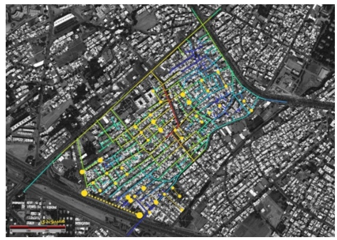
Figure 2. Comparison of unsafe streets (based on respondents) with the integration of Qalamestan
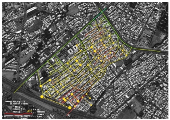
Figure 3. Comparison of unsafe streets (based on respondents) with the depth map of Qalamestan.
For a detailed evaluation, 43 streets were selected in total, and their security was assessed using the “Checklist for Examining the Role of Environmental Factors in Crime-Prone Urban Public Spaces.” According to the mode method, the criteria were quantified, and security levels were determined across the twelve components. To analyze the relationship between integration, depth, and security, the required data were extracted and classified. For each street, the quantitative security score (percentage) from the checklist and the relative values of integration and depth derived from UCL Depthmap 10.1 software were presented. Since all measures were quantified, they were comparable. Pearson’s product-moment correlation was then used to test the hypothesis that “variations in security across the streets of Qalamestan are significantly correlated with changes in integration and depth.”
The Pearson correlation coefficient between security and integration was 0.784, indicating a significant positive correlation (r=0.784, p<0.001). This means that as integration increases in Qalamestan’s streets, so does their security. Meanwhile, the correlation between security and depth was –0.767, also significant (r=–0.767, p<0.001). This negative correlation implies that as depth increases, security decreases.
Based on these findings, there is a significant relationship between security, integration, and depth. This stage of the analysis translated the data into practical outputs and provided design-oriented solutions. Following spatial configuration analyses of Qalamestan’s street network, an improvement plan was proposed to enhance security based on the integration and depth measures. The proposed plan was re-analyzed using the space syntax technique in Depthmap 10, and the results were compared.
In the final stage, the proposed designs were reassessed using the same analytical methods applied during the design process, and the effectiveness of each was evaluated. Quantitative changes in the overall proposed plan compared to the existing conditions were assessed across the components of integration, depth, choice, control, and connectivity.
The average global integration increased from 0.781 to 0.922. These changes occurred without altering the relative hierarchy of streets; instead, the integration of key streets increased relative to the network as a whole. For instance, integration values in Tolu‘i, Baghdadi, and Gholamhoseini streets rose from 0.784 to 0.908, 0.779 to 0.922, and 0.620 to 0.791, respectively. Similar patterns were observed in depth. The average depth decreased from 13.309 to 10.954, reflecting improved spatial conditions in Qalamestan.
Assessment of integration and depth changes in the proposed street network redesign showed that the mean global integration increased by 20% (from 0.536 to 0.646). This increase ranged from 18% at the minimum to 37.2% at the maximum. Meanwhile, the mean depth decreased by 17.6% (from 13.309 to 10.954), ranging from a 15.1% reduction at the minimum to a 27.3% reduction at the maximum. Given the direct correlation between integration and security, and the inverse correlation between depth and security, these spatial configuration changes indicate overall improvements in security across Qalamestan’s streets.
Discussion
The aim of this study was to investigate the relationship between spatial configuration parameters and women’s safety in the deteriorated fabric of Qalamestan neighborhood in Karaj. In this article, the configurational and quantitative characteristics of the neighborhood were described and measured using the space syntax technique.
The findings of this research indicated that locations with higher integration exhibited lower rates of insecurity, whereas places with poor accessibility (greater depth) had higher levels of insecurity. This outcome is consistent with the classical perspectives in this field, namely the theories of Jacobs and Hillier [Hillier, 2007; Jacobs, 1992]. However, not all space syntax studies have supported these findings. The discrepancies among them can, to some extent, be attributed to differences in the analytical units employed and the lifestyle of residents in the study areas. These aspects highlight the complexity of the relationship between spatial structure (space syntax) and crime occurrence.
In this study, the relationship between spatial configuration parameters, namely integration and depth, and the safety of streets in Qalamestan was first assessed. Safety data were collected through two instruments: A questionnaire and a checklist titled “Checklist for Examining the Role of Environmental Factors in Crime-Prone Urban Public Spaces.” The questionnaire results regarding residents’ sense of safety showed no significant correlation between integration and depth. This finding is similar to the study by Jabbary et al. [2019], but inconsistent with the results of Matijosaitiene [2016], who found that crime rates, particularly theft, increased with greater depth of urban streets. Therefore, preventive measures drawn from urban safety theories such as CPTED should be applied to enhance safety in such areas.
Nevertheless, the correlation between checklist-derived safety data and the integration and depth values of Qalamestan’s street network revealed a significant positive relationship between integration and safety, and a significant negative relationship between depth and safety. This result aligns with studies conducted in Iranian cities by Zarabadi et al. [2015], Sajjadzadeh et al. [2017], Maroofi & Jafari [2018], and Mirmoini & Jalili [2020]. Accordingly, it can be stated that increasing integration and reducing depth in urban street networks contribute to improved safety. This conclusion was also confirmed in Paydar et al.’s [2017] study in Santiago, Chile, where higher integration was significantly associated with women’s choice of walking routes in which they felt safe.
However, this relationship may not extend to certain crimes, such as theft, particularly along main urban streets, as noted by Jabbary et al. [2019]. Low integration and high depth in the deteriorated fabric indicate a lack of connectivity within the street network. This condition restricts accessibility and reduces natural surveillance, thereby contributing to feelings of insecurity. This finding is consistent with the theory of urban fabric segregation, which argues that spatial isolation produces negative consequences, including insecurity [Rismanchian & Bell, 2010].
The second part of the study investigated the extent of positive changes brought about by street improvement plans. Few comparable studies exist, though a similar method is applied by Erinsel et al. [2010], which produces analogous results in spatial configuration analysis of urban design projects.
The most important limitation of this study was the reliance on competing theories and their measurement solely within Qalamestan. If the relationship between theories such as CPTED and space syntax parameters had been independently assessed in terms of women’s perception of safety, further strategies for improving neighborhood security might have been identified. Furthermore, both Iranian [Shariati et al., 2017] and international studies [Basu et al., 2021; Pozarny, 2016] report that women’s sense of safety in urban spaces is lower than that of men. This is consistent with the findings of Bonyadi et al. [2023], also conducted in Qalamestan, which showed that women perceived lower levels of safety than men across most research parameters in neighborhood streets and public spaces.
It should be noted that the findings of this research are consistent with the views of classical scholars such as Jacobs and Hillier. The discrepancies in prior studies can be attributed to treating different forms of disorder affecting safety perceptions, as well as varying degrees of environmental factors, in the same manner.
Finally, the following recommendations are presented for improving safety in deteriorated urban fabrics:
Conclusion
There is a significant relationship between the spatial syntax parameters of Qalamestan’s street network and women’s safety. With an increase in street integration, women’s safety also improves. Accordingly, a plan was proposed to enhance this indicator, in which the level of integration was increased and street depth was reduced. In addition, the average level of connectivity decreased in commercial streets, while it showed a slight increase in residential streets. In Qalamestan neighborhood, women’s satisfaction with local safety is below average. Therefore, by increasing integration and reducing depth in the neighborhood’s street network, safety in the streets can be improved
Acknowledgments: None declared by the authors.
Ethical Permission: The authors have adhered to the principles and standards of research ethics, including integrity, confidentiality, and honesty.
Conflict of Interest: None declared by the authors.
Authors’ Contributions: Yousefi AH (First Author): Main researcher (30%); Khaki M (Second Author): Methodologist/Assistant Researcher (30%); Fathi M (Third Author): Discussion Writer (25%); Sadati M (Fourth Author): Introduction writer (15%)
Funding: None declared by the authors.
Security in large cities and metropolises, particularly for specific social groups such as women is a priority in urban planning and management. The physical and spatial qualities that contribute to improved security are among the criteria influencing property value and economic development in different neighborhoods. In this context, the role of women is crucial, since they often experience public spaces differently, leading to a distinct perception of security compared to men.
Today, various perspectives and theories have been proposed on how to enhance security in urban spaces, each with its supporters and critics [Hillier, 2007; Salehi, 2008; Habibi et al., 2019]. Despite numerous differences and contradictions, each approach has introduced mechanisms aimed at maximizing social control through environmental design. On the other hand, several studies show that a significant relationship exists between the spatial structure and form of the city and social and economic processes [Shakibamanesh et al., 2018; Doroudi & Sami, 2017; Sajjadzadeh et al., 2017; Nubani, 2005; De Rooij & Van Nes, 2015].
Recent research and theories on crime prevention and the enhancement of the sense of security can be classified into three approaches: “non-spatial,” “spatial,” and “legal” [Soori, 2009; Shokrani, 2015]. Among these, the physical environment is considered at least as important as the social environment, if not more so [Gheshlaghpoor & Babakhani, 2021], because it consists of fixed elements that can be planned and designed to reduce opportunities for crime. Accordingly, the present article adopts the “spatial” approach and seeks to identify spatial components that influence the perception of security.
Within this framework, Salehi proposed twelve components: scale, form and space, lighting, crowding, visual pollution, symbolic pollution, environmental pollution, noise pollution, access to public transport services, permeability control, overall quality of housing in neighborhoods adjacent to public spaces, and the quality of activities and land use [Salehi, 2008]. These components closely correspond to the criteria of two major approaches: Crime Prevention Through Environmental Design (CPTED) and Secured By Design (SBD) [Bonyadi et al., 2023], and thus are also adopted in this study. From a “spatial” perspective, achieving urban security requires the enhancement of all these indicators.
Based on both domestic and international research, women generally report feeling less secure than men [Bemanian et al., 2009; Shariati et al., 2017; Basu et al., 2021; Pozarny, 2016]. This has resulted in reduced participation of women in public spaces compared to men. Given the focus of the present research on women, assessing their level of security in urban environments and providing solutions to reduce their sense of insecurity becomes especially important.
Security is a relative and multidimensional concept; however, most scholars in urban studies and social sciences agree that it is shaped by two main dimensions: objective and subjective [Golmakani & Akbarpur, 2017; Cross, 2013]. Objectively, security means the absence of threats to acquired values, while subjectively, it refers to the lack of fear and anxiety about potential attacks and the loss of those values [Tekyeabady & Darbanastane, 2016]. In this sense, an individual’s perceived insecurity may not necessarily align with external and tangible realities [Abdullah et al., 2012]. This discrepancy makes it essential to evaluate security perceptions among different social groups, since analyzing factors influencing security without considering personal characteristics will be incomplete.
Research also demonstrates that crime-prone and insecure zones often overlap with deteriorated, dysfunctional, and indefensible urban areas [Bozorgvar et al., 2016]. Due to their spatial and physical features as well as social and cultural characteristics, these areas are more susceptible to abnormalities compared to other urban zones [Bonyadi et al., 2023].
Among different urban fabrics, deteriorated areas both functionally and physically provide a more conducive environment for the emergence of crime-prone locations. At the same time, the complexity of urban society and the need for evaluation tools in urban planning necessitate the use of up-to-date techniques for prediction and design control. One such effective method is the space syntax model, which explores the relationship between the built environment and residents’ social life. This technique is primarily used to assess the capacity of proposed urban plans in fulfilling planning objectives [Rismanchian & Bell, 2010]. Beyond analyzing existing structures, it can also be applied to evaluate urban development projects and predict the potential outcomes of their implementation.
Although most related studies indicate a significant relationship between spatial configuration and the perception of security, only in some cases has this relationship been predictive. Thus, further evaluation within specific study areas is required. Additionally, some studies suggest an inverse relationship between two space syntax measures, “connectivity” and “choice” and security, particularly in crimes such as theft [Jabbary et al., 2019; Chang, 2011; De Rooij & Van Nes, 2015; Wu et al., 2015], since high connectivity may facilitate offenders’ escape. This was also emphasized in Hillier’s studies [Hillier, 2007]. Therefore, in urban commercial corridors, increased connectivity may negatively affect security by facilitating crimes like theft, whereas in residential neighborhoods, greater connectivity and choice are positively associated with security [Maroofi & Jafari, 2018; Bonyadi et al., 2023; Matijosaitiene, 2014].
To properly analyze the relationship between the environment and security, different aspects of security should be studied separately, as each is influenced differently by environmental conditions [Sajjadzadeh et al., 2017]. Furthermore, among physical elements, detailed aspects such as visibility of spaces may influence crime occurrence more significantly than larger-scale spatial configurations [Shokrani, 2015]. Hence, it is necessary that the results of such analyses be considered in urban planning and design alongside other physical parameters. Additionally, urban safety studies and planning are better reviewed using computer-based tools grounded in space syntax methodology.
In security research applying space syntax, the fundamental assumption is that increasing “natural surveillance” by people in public spaces reduces the likelihood of crime, thereby improving safety. Based on this assumption, applying space syntax analysis to identify spatial factors enhancing security in deteriorated urban areas, particularly for vulnerable social groups such as women can be insightful. Accordingly, the present study aims to examine the relationship between spatial configuration parameters and women’s security in deteriorated urban fabric.
Methodology
This study is of an applied type and was conducted in 2023 in the Qalamestan neighborhood of Karaj using a correlational research design. The analysis was carried out at two levels: the “macro scale” and the “internal street network” of the Qalamestan neighborhood. The research process was divided into five stages: data collection, analysis, comparison, design proposal, and reassessment of recommendations. The entire process took three months during the spring of 2023.
The study area, the deteriorated fabric of Qalamestan, is one of the old neighborhoods located in central Karaj. An examination of Karaj’s metropolitan structure revealed significant differences between semi-organic fabrics in the central areas and newer urban developments. The deteriorated fabric of Qalamestan covers an area of 12.64 hectares, of which 6.88 hectares are allocated to open spaces and streets, while 5.55 hectares are occupied by various land uses. In fact, 86% of the deteriorated fabric consists of built-up areas, and the remaining 14% belongs to open spaces and streets [Khodavand Consultant Engineers, 2015].
To analyze the spatial configuration of Qalamestan, the axial map of Karaj was first drawn at a scale of 1:5000. An axial map is formed by the minimum set of straight lines passing through convex spaces that cover all axial connections, while a convex map consists of a set of spaces that collectively cover the system [Erinsel et al., 2010].
From the axial map, the key space syntax indicators “integration,” “depth,” “choice,” and “connectivity” were extracted using UCL Depthmap 10 software. Axial map analysis can be conducted either topologically or metrically. In this study, a topological method was used, where the analysis of the street network is relative and not dependent on the map scale. The outputs from data analysis in the software included three forms: graphical maps, quantitative information, and correlation charts of spatial configuration components.
Data on the security of the study area were collected using two methods: questionnaires and checklists. For each street, the “Checklist for Examining the Role of Environmental Factors in Crime-Prone Urban Public Spaces” was applied. This checklist includes 120 tests across twelve main components and indicators, developed in the research project “Formulation of Regulations for Securing Urban Spaces in Terms of Citizen Safety and Crime Prevention” [Salehi, 2008]. Subsequently, additional data were collected from women in Qalamestan through a researcher-designed questionnaire.
The questionnaire, developed based on theoretical indicators and aligned with the checklist, included 83 items, covering 24 criteria at three levels: “residential unit,” “streets and public spaces,” and “neighborhood.” The objective was to evaluate the sense of security among women living in the deteriorated fabric of Qalamestan. The questionnaire’s face and content validity were confirmed by 12 university professors and experts familiar with the study area. For this purpose, the Content Validity Index (CVI) was used. Items with a CVI above 0.75 were approved. Reliability was assessed using Cronbach’s alpha coefficient to measure internal consistency. All parameters achieved a Cronbach’s alpha greater than 0.70, indicating acceptable reliability of the questionnaire at all three levels.
The research sample was selected in two stages. In both, Cochran’s formula with a 0.05 error rate was applied to determine sample size. First, for distributing the questionnaire, a sample of 348 women (residents or pedestrians in Qalamestan) was surveyed. Second, the sample of streets to be studied was selected. Out of 102 total streets in the neighborhood, 43 were determined as the sample based on the same formula and error rate.
The checklist and questionnaire data, measured on a Likert scale, were quantified and analyzed using the mode method as a measure of central tendency. After removing inconsistent data, correlation analysis was conducted in SPSS version 23 to examine the relationships between parameters. In this process, spatial configuration parameters were considered independent parameters, while security parameters were treated as dependent parameters. Finally, recommendations were proposed based on relationships that were statistically significant and sufficiently correlated.
Findings
The analysis began with the preparation of an axial map. By drawing the axial map of Karaj, various spatial configuration parameters for both the city and the study area were extracted. For localized analysis in the Qalamestan neighborhood, local integration, local depth, local choice, and connectivity were assessed. In these maps, each line (street) is colored along a spectrum from warm (brown) to cool (dark blue), where warm colors indicate higher values (maximum 10) and cool colors indicate lower values (minimum 0). The highest levels of integration and choice were observed along the peripheral streets of the neighborhood as well as the central (north–south and east–west) axes. This was also reflected in the concentration of commercial land uses along these axes.
According to data derived from the questionnaire, women’s sense of security in Qalamestan was 45.23%. Regarding security indicators in the neighborhood, despite the fact that a large proportion of residents (37.6%) had lived there for more than 12 years, neighborhood familiarity and interaction with neighbors were rated as moderate or low by 58% of respondents.
Checklist data, after calculating the mode and extracting the quantitative desirability of each component, were analyzed. For aggregating the twelve components and deriving the overall desirability of the neighborhood in terms of environmental security factors, the percentage of each component was calculated and the final result determined. Based on this, the role of physical-spatial components in security was calculated at 52.98.
To evaluate the relationship between spatial configuration analyses and street security in Qalamestan, the streets identified by respondents as unsafe were first marked on the neighborhood map. The size of each mark corresponded to the frequency of responses. These markings were then compared with the neighborhood’s depth and integration maps (Figures 2 and 3). This comparison showed no significant correlation between unsafe streets and integration or depth, as streets with similar integration and depth values were not consistently identified as unsafe by respondents.
Figure 2. Comparison of unsafe streets (based on respondents) with the integration of Qalamestan
Figure 3. Comparison of unsafe streets (based on respondents) with the depth map of Qalamestan.
For a detailed evaluation, 43 streets were selected in total, and their security was assessed using the “Checklist for Examining the Role of Environmental Factors in Crime-Prone Urban Public Spaces.” According to the mode method, the criteria were quantified, and security levels were determined across the twelve components. To analyze the relationship between integration, depth, and security, the required data were extracted and classified. For each street, the quantitative security score (percentage) from the checklist and the relative values of integration and depth derived from UCL Depthmap 10.1 software were presented. Since all measures were quantified, they were comparable. Pearson’s product-moment correlation was then used to test the hypothesis that “variations in security across the streets of Qalamestan are significantly correlated with changes in integration and depth.”
The Pearson correlation coefficient between security and integration was 0.784, indicating a significant positive correlation (r=0.784, p<0.001). This means that as integration increases in Qalamestan’s streets, so does their security. Meanwhile, the correlation between security and depth was –0.767, also significant (r=–0.767, p<0.001). This negative correlation implies that as depth increases, security decreases.
Based on these findings, there is a significant relationship between security, integration, and depth. This stage of the analysis translated the data into practical outputs and provided design-oriented solutions. Following spatial configuration analyses of Qalamestan’s street network, an improvement plan was proposed to enhance security based on the integration and depth measures. The proposed plan was re-analyzed using the space syntax technique in Depthmap 10, and the results were compared.
In the final stage, the proposed designs were reassessed using the same analytical methods applied during the design process, and the effectiveness of each was evaluated. Quantitative changes in the overall proposed plan compared to the existing conditions were assessed across the components of integration, depth, choice, control, and connectivity.
The average global integration increased from 0.781 to 0.922. These changes occurred without altering the relative hierarchy of streets; instead, the integration of key streets increased relative to the network as a whole. For instance, integration values in Tolu‘i, Baghdadi, and Gholamhoseini streets rose from 0.784 to 0.908, 0.779 to 0.922, and 0.620 to 0.791, respectively. Similar patterns were observed in depth. The average depth decreased from 13.309 to 10.954, reflecting improved spatial conditions in Qalamestan.
Assessment of integration and depth changes in the proposed street network redesign showed that the mean global integration increased by 20% (from 0.536 to 0.646). This increase ranged from 18% at the minimum to 37.2% at the maximum. Meanwhile, the mean depth decreased by 17.6% (from 13.309 to 10.954), ranging from a 15.1% reduction at the minimum to a 27.3% reduction at the maximum. Given the direct correlation between integration and security, and the inverse correlation between depth and security, these spatial configuration changes indicate overall improvements in security across Qalamestan’s streets.
Discussion
The aim of this study was to investigate the relationship between spatial configuration parameters and women’s safety in the deteriorated fabric of Qalamestan neighborhood in Karaj. In this article, the configurational and quantitative characteristics of the neighborhood were described and measured using the space syntax technique.
The findings of this research indicated that locations with higher integration exhibited lower rates of insecurity, whereas places with poor accessibility (greater depth) had higher levels of insecurity. This outcome is consistent with the classical perspectives in this field, namely the theories of Jacobs and Hillier [Hillier, 2007; Jacobs, 1992]. However, not all space syntax studies have supported these findings. The discrepancies among them can, to some extent, be attributed to differences in the analytical units employed and the lifestyle of residents in the study areas. These aspects highlight the complexity of the relationship between spatial structure (space syntax) and crime occurrence.
In this study, the relationship between spatial configuration parameters, namely integration and depth, and the safety of streets in Qalamestan was first assessed. Safety data were collected through two instruments: A questionnaire and a checklist titled “Checklist for Examining the Role of Environmental Factors in Crime-Prone Urban Public Spaces.” The questionnaire results regarding residents’ sense of safety showed no significant correlation between integration and depth. This finding is similar to the study by Jabbary et al. [2019], but inconsistent with the results of Matijosaitiene [2016], who found that crime rates, particularly theft, increased with greater depth of urban streets. Therefore, preventive measures drawn from urban safety theories such as CPTED should be applied to enhance safety in such areas.
Nevertheless, the correlation between checklist-derived safety data and the integration and depth values of Qalamestan’s street network revealed a significant positive relationship between integration and safety, and a significant negative relationship between depth and safety. This result aligns with studies conducted in Iranian cities by Zarabadi et al. [2015], Sajjadzadeh et al. [2017], Maroofi & Jafari [2018], and Mirmoini & Jalili [2020]. Accordingly, it can be stated that increasing integration and reducing depth in urban street networks contribute to improved safety. This conclusion was also confirmed in Paydar et al.’s [2017] study in Santiago, Chile, where higher integration was significantly associated with women’s choice of walking routes in which they felt safe.
However, this relationship may not extend to certain crimes, such as theft, particularly along main urban streets, as noted by Jabbary et al. [2019]. Low integration and high depth in the deteriorated fabric indicate a lack of connectivity within the street network. This condition restricts accessibility and reduces natural surveillance, thereby contributing to feelings of insecurity. This finding is consistent with the theory of urban fabric segregation, which argues that spatial isolation produces negative consequences, including insecurity [Rismanchian & Bell, 2010].
The second part of the study investigated the extent of positive changes brought about by street improvement plans. Few comparable studies exist, though a similar method is applied by Erinsel et al. [2010], which produces analogous results in spatial configuration analysis of urban design projects.
The most important limitation of this study was the reliance on competing theories and their measurement solely within Qalamestan. If the relationship between theories such as CPTED and space syntax parameters had been independently assessed in terms of women’s perception of safety, further strategies for improving neighborhood security might have been identified. Furthermore, both Iranian [Shariati et al., 2017] and international studies [Basu et al., 2021; Pozarny, 2016] report that women’s sense of safety in urban spaces is lower than that of men. This is consistent with the findings of Bonyadi et al. [2023], also conducted in Qalamestan, which showed that women perceived lower levels of safety than men across most research parameters in neighborhood streets and public spaces.
It should be noted that the findings of this research are consistent with the views of classical scholars such as Jacobs and Hillier. The discrepancies in prior studies can be attributed to treating different forms of disorder affecting safety perceptions, as well as varying degrees of environmental factors, in the same manner.
Finally, the following recommendations are presented for improving safety in deteriorated urban fabrics:
- In rehabilitation projects, before making decisions regarding street redesign, environmental parameters and their relationship with spatial structure should be modeled and forecasted, and insecurity-inducing factors, especially for women, should be eliminated.
- The average street depth in informal settlements is considerably higher than the average depth index of Karaj’s urban structure. This exacerbates the segregation of certain streets within the informal settlement itself. Therefore, reducing depth should be prioritized in rehabilitation plans
Conclusion
There is a significant relationship between the spatial syntax parameters of Qalamestan’s street network and women’s safety. With an increase in street integration, women’s safety also improves. Accordingly, a plan was proposed to enhance this indicator, in which the level of integration was increased and street depth was reduced. In addition, the average level of connectivity decreased in commercial streets, while it showed a slight increase in residential streets. In Qalamestan neighborhood, women’s satisfaction with local safety is below average. Therefore, by increasing integration and reducing depth in the neighborhood’s street network, safety in the streets can be improved
Acknowledgments: None declared by the authors.
Ethical Permission: The authors have adhered to the principles and standards of research ethics, including integrity, confidentiality, and honesty.
Conflict of Interest: None declared by the authors.
Authors’ Contributions: Yousefi AH (First Author): Main researcher (30%); Khaki M (Second Author): Methodologist/Assistant Researcher (30%); Fathi M (Third Author): Discussion Writer (25%); Sadati M (Fourth Author): Introduction writer (15%)
Funding: None declared by the authors.
Keywords:
References
1. Abdullah A, Abd Razak N, Salleh MNM, Sakip SRM (2012). Validating crime prevention through environmental design using structural equation model. Procedia-Social and Behavioral Sciences. 36:591-601. [Link] [DOI:10.1016/j.sbspro.2012.03.065]
2. Basu N, Haque MM, King M, Kamruzzaman M, Oviedo-Trespalacios O (2021). The unequal gender effects of the suburban built environment on perceptions of security. Journal of Transport & Health. 23:101243. [Link] [DOI:10.1016/j.jth.2021.101243]
3. Bemanian MR, Rafieian M, Zabetian E (2009). An evaluation of factors affecting women's safety in urban environments. Woman in Development & Politics. 7(3):49-67. [Persian] [Link]
4. Bonyadi N, Fathi M, Jahdi N (2023). Evaluation of urban plans based on security improvement in deteriorated area using space syntax (case study: Qalamestan Karaj). Research and Urban Planning. 14(53):151-168. [Persian] [Link]
5. Bozorgvar A, Zyari K, Taqvai M (2016). Security sense measurement of citizens in hashtgerd new town. Urban Management. 16(49):367-385. [Persian] [Link]
6. Chang D (2011). Social crime or spatial crime? Exploring the effects of social, economical, and spatial factors on burglary rates. Journal of Environment and Behavior. 43(1):26-52. [Link] [DOI:10.1177/0013916509347728]
7. Cross M (2013). Social media security: Leveraging social networking while mitigating risk. Oxford: Syngress. [Link]
8. De Rooij L, Van Nes A (2015). The perceived safety and spatial behavior in three different neighbourhoods in Rotterdam. Proceedings of the 10th international space syntax symposium. London: Space Syntax Laboratory. [Link]
9. Doroudi MR, Sami S (2017). Evaluation of factors affecting promoted sense of security inresidential environments (case study: West Tehranpars,Iran). Journal of Humanities and Cultural Studies R&D. 2(2):102-133. [Link]
10. Erinsel Önder D, Gigi Y (2010). Reading urban spaces by the space-syntax method: A proposal for the South Haliç Region. Cities. 27(4):260-271. [Link] [DOI:10.1016/j.cities.2009.12.006]
11. Gheshlaghpoor S, Babakhani M (2021). Analysis of crime prevention factors through environmental design (CPTED) in Mehr Housing, case study: Mehr Housing of Nazarabad City. Armanshahr Architecture & Urban Development. 14(36):161-175. [Persian] [Link]
12. Golmakani M, Akbarpur Ganje A (2017). Enhancing security in urban spaces using the environmental design approach (CEPTED); case study: The Sadeghie second roundabout. Intenational Journal of Urban and Rural Management. 16(47):687-699. [Persian] [Link]
13. Habibi L, Nikpour A, Najafi M (2019). Analysis of the sense of safety for women in urban public spaces with emphasis on physical elements (case study of Amol). Journal of Urban and Regional Development Planning. 4(8):179-202. [Persian] [Link]
14. Hillier Bill (2007). Space is the machine: a configurational theory of architecture. London: Space Syntax. [Link]
15. Jabbary M, Nastaran M, Mohammadi M, Kalantari M (2019). Analysis of spatial structure of the centers of theft and drug crimes in Tehran by way of space arrangement with an emphasis on the network of passages. journal of police Geography. 6(23):27-50. [Persian] [Link]
16. Jacobs J (1992). The death and life of great American cities. New York: Vintage. [Link]
17. Khodavand Consultant Engineers (2015). Improvement and renovation project of worn-out Karaj fabric (report of rules and regulations). Tehran: Khodavand Consultant Engineers. [Persian] [Link]
18. Maroofi S, Jafari M (2018). The role of spatial configuration of neighborhoods in residents' security by "space syntax" method. Research and Urban Planning. 9(34):119-132. [Persian] [Link]
19. Matijosaitiene I (2014). Urban crime in the city of New Haven: Residential burglaries. Journal of Sustainable Architecture and Civil Engineering. 4(9):16-25. [Link] [DOI:10.5755/j01.sace.9.4.7225]
20. Matijosaitiene I (2016). Combination of CPTED and space syntax for the analysis of crime. Safer Communities. 15(1):49-62. [Link] [DOI:10.1108/SC-05-2015-0013]
21. Mirmoini M, Jalili Sadrabad S (2020). Environmental security evaluation using space syntax theory and place-check technique; case study: Saraseyb neighborhood. Geography. 17(62):218-242. [Persian] [Link]
22. Nubani L (2005). The role of space syntax in identifying the relationship between space and crime. Proceedings of 5th International Space Syntax Symposium. p. 413-422. [Link]
23. Paydar M, Kamani-Fard A, Etminani-Ghasrodashti R (2017). Perceived security of women in relation to their path choice toward sustainable neighborhood in Santiago, Chile. Cities. 60:289-300. [Link] [DOI:10.1016/j.cities.2016.10.002]
24. Pozarny P (2016). Gender roles and opportunities for women in urban environments. Governance and Social Development Resource Centre (GSDRC). Helpdesk Research Report. [Link]
25. Rismanchian O, Bell S (2010). The application of space Syntax in studying the structure of the cities. Journal of Fine Arts: Architecture and Urban Planning. 2(43):49-56. [Persian] [Link]
26. Sajjadzadeh H, Izadi M, Haghi M (2017). The relationship between spatial configuration and environmental security in informal settlements of Hamedan. Journal of Fine Arts: Architecture and Urban Planning. 22(2):19-28. [Link]
27. Salehi E (2008). Environmental characteristics of safe urban spaces. 1st edition. Tehran: Urban Planning and Architecture Research Center. [Persian] [Link]
28. Shakibamanesh A, Ayashm M, Ghobadi P (2018). Investigating the effect of urban squares visibility on the psychological security of pedestrians using the three-dimensional isovist technique (case study: The Saat Square and Namaz Square of Tabriz). Journal of Iranian Architecture & Urbanism (JIAU). 9(1):121-134. [Persian] [Link]
29. Shariati Mazinani S, Foroghzadeh S (2017). Urban public spaces and women security: The case study of Mashhad. Strategic Research on Social Problems in Iran. 6(4):71-90. [Persian] [Link]
30. Shokrani M (2015). Analysis of the effect of the shape of urban spaces on the incidence of integrated environmental crimes using isovist and space layout (study sample: Neighborhoods of Urmia) [dissertation]. Tabriz: Faculty of Architecture and Urbanism-Tabriz Islamic Art University. [Persian] [Link]
31. Soori E (2009). A review of theoretical controversy about security and crime prevention methods. Armanshahr Architecture & Urban Development. 2(2):31-38. [Persian] [Link]
32. Tekyeabady M, Darbanastane A (2016). Factors affecting the feeling of security with an emphasis on social factors (case study: The villages of south of Tehran province). Urban Management. 15(42):7-22. [Persian] [Link]
33. Wu L, Liu X, Ye X, Leipnik M, Lee J, Zhu X (2015). Permeability, space syntax, and the patterning of residential burglaries in urban China. Applied Geography. 60:261-265. [Link] [DOI:10.1016/j.apgeog.2014.12.001]
34. Zarabadi Z, Habib F, Takalou S (2015). Site selection of safe public spaces in urban neighborhoods by using space syntax method (case study: Vardavard neighborhoods in Tehran). Urban Regional Studies and Research. 7(26):1-22. [Persian] [Link]