
Bilingual
En/Fa
Geographical Research is Published in both Persian and English Full-text.
Volume 38, Issue 3 (2023)
GeoRes 2023, 38(3): 319-329 |
Back to browse issues page
Article Type:
Subject:


History
Received: 2023/07/27 | Accepted: 2023/09/16 | Published: 2023/10/2
Received: 2023/07/27 | Accepted: 2023/09/16 | Published: 2023/10/2
How to cite this article
Behrawan H, Yarahmadi J, Abbasi H. Identification and Monitoring of Sand and Dust Storms Sources (SDSS) in East Azarbaijan Province. GeoRes 2023; 38 (3) :319-329
URL: http://georesearch.ir/article-1-1507-en.html
URL: http://georesearch.ir/article-1-1507-en.html
Download citation:
BibTeX | RIS | EndNote | Medlars | ProCite | Reference Manager | RefWorks
Send citation to:


Rights and permissions
BibTeX | RIS | EndNote | Medlars | ProCite | Reference Manager | RefWorks
Send citation to:

1- Department of Soil Conservation and Watershed Management, East Azarbaijan Agricultural and Natural Resources Research and Education Center, Tabriz, Iran
2- Department of Desert Research, Research institute of Forests and Rangelands, Tehran, Iran
2- Department of Desert Research, Research institute of Forests and Rangelands, Tehran, Iran
Full-Text (HTML) (401 Views)
Introduction
Dust storms are among the most serious natural hazards, influencing climate change [An et al., 2018; Schepanski, 2018; Salehi et al., 2019], marine ecosystems [Bali et al., 2019], snow cover and glaciers [Kutuzov et al., 2019], vegetation, visibility, solar power plants, wildlife [Naji & Taherpour, 2019], as well as various aspects of human health and livelihood [Ardon-Dryer et al., 2020; Opp et al., 2021]. Dust particles represent the heaviest atmospheric aerosols and are attracted to synoptic-scale phenomena such as El Niño [Li et al., 2021; Labban & Butt, 2021]. In addition, dust storms directly affect vegetation [Ebrahimi Khusfi et al., 2020; Hossein Hamzeh et al., 2022], soil texture, and precipitation rates [Dar et al., 2022].
Deserts constitute the largest source of global dust storms [Middleton, 2017]. However, several desiccated lakes have recently emerged as significant new sources of dust worldwide. Numerous dried lakebeds are found across the Middle East and Central Asia. Among them, the Aral Sea, located between Kazakhstan and Uzbekistan [Karami et al., 2021; Opp et al., 2017], is one of the most well-known examples. The Hamoun Lakes in Iran’s Sistan region [Miri et al., 2021] and Lake Urmia in northwestern Iran [Mardi et al., 2018; Boroughani et al., 2019] also represent major dust sources. The chemical composition and grain size of suspended particles lifted from desiccated lakebeds differ considerably from desert-originated dust storms and most saline storms emerging from dried lakes [Opp et al., 2017]. Salt aerosols tend to remain airborne for extended periods [Liu et al., 2011].
Over the past two decades, dust from Lake Urmia has increasingly affected adjacent areas. The frequency of dust events has shown a significant inverse correlation with the lake’s extent [Opp et al., 2017], as its exposed bed is one of the largest saline dust sources in Iran. The lake’s water storage capacity has dramatically declined in recent years, resulting in more frequent saline dust storms. Although climatic factors have contributed to Lake Urmia’s shrinkage, long-term analyses highlight that anthropogenic impacts on its watershed have played a more decisive role in its desiccation [Alizade Govarchin Ghale et al., 2018]. Based on a 40-year analysis, Delju et al. [2013] reported a 9% decrease in precipitation over the lake coupled with an increase of 0.8°C in mean maximum surface temperature. Human-induced drivers are estimated to account for nearly 80% of Lake Urmia’s desiccation, while climatic factors contribute about 20% [Ahmady-Birgani et al., 2020]. Dam construction, agricultural irrigation, and the establishment of a transportation route across the lake are identified as primary anthropogenic causes [Hassanzadeh et al., 2012].
A similar catastrophe occurred in the Aral Sea, which since the 1990s has become one of the most severe environmental disasters in Central Asia [Singer et al., 2003; Indoitu et al., 2015]. Over the past three decades, the Aral Sea has evolved into a major dust source and salt hotspot within the Aralkum Desert, formed on its dried seabed. Both water bodies and vegetation in the basin have declined dramatically, while dust and salt storms have substantially increased [Kochkarova & Mambetullaeva, 2020]. These storms predominantly affect Kazakhstan, Uzbekistan, and Turkmenistan, though in recent years they have also reached northeastern Iran, Tajikistan, and Afghanistan [Singer et al., 2003]. The primary causes of the lake’s water loss are expansion of irrigated croplands, particularly cotton, as the dominant crop, rising water withdrawals from its tributaries, and rapid population growth in surrounding regions [Soudi et al., 2017].
The present study aims to identify and analyze dust and particulate matter sources in East Azerbaijan Province, Iran, and to characterize the properties of these lands. The main stages of the study involved identifying dust-generating zones, determining their general characteristics, measuring and monitoring dust and aeolian sediment production, and delineating the major and sensitive dust-producing areas within East Azerbaijan Province.
Methodology
Identification of Dust-Generating Areas
Several approaches were employed to identify dust emission sources:
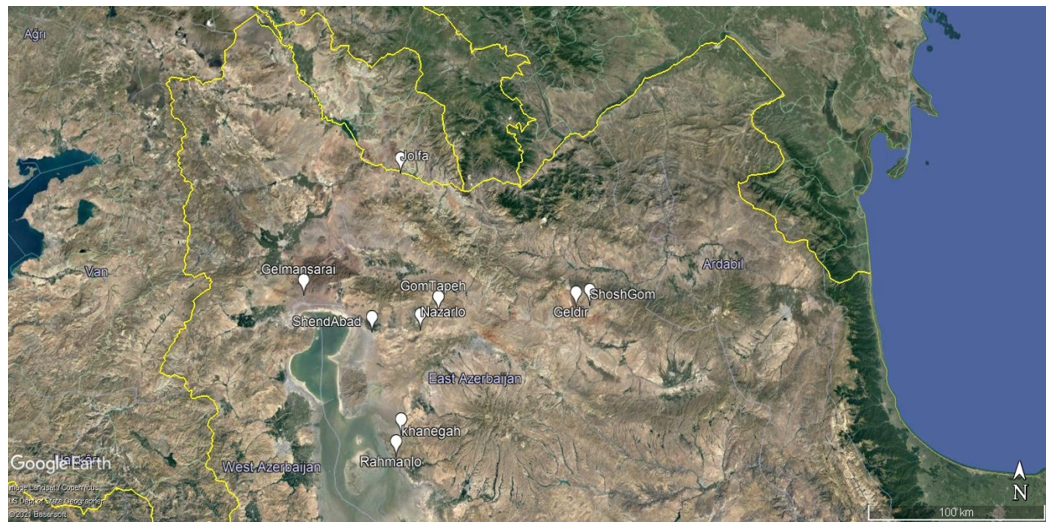
Figure 1. Locations of soil sampling sites in East Azerbaijan Province
Measurement and Monitoring of Dust and Aeolian Sediment Production
Furthermore, to develop a suitable geostatistical model, the wind erosion threshold was determined using a wind tunnel experiment on intact soil samples placed in tray-shaped containers (30 × 50 × 5 cm). The quantity of aeolian sediments generated from each representative land unit was measured using specially designed sediment collectors at wind velocities of 5, 10, 15, 20, and 25 m/s within the wind tunnel.
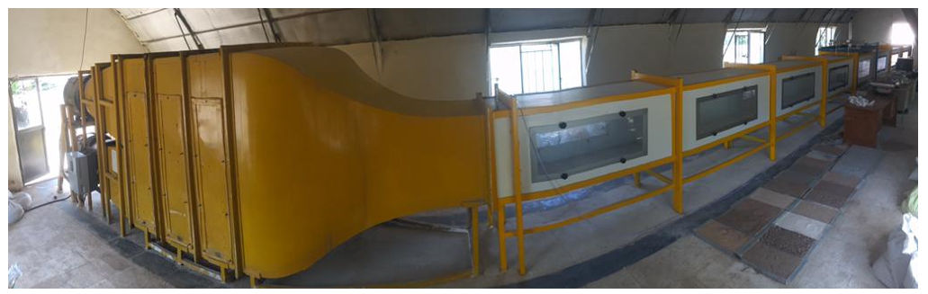
Figure 2. The wind tunnel used in this study
The threshold velocity was computationally determined by measuring soil loss at varying wind speeds. Using the regression equation of soil loss versus wind speed, the threshold velocity was defined as the point at which soil loss approaches zero.
Equation (1)
(kg m-2 min-1)
Findings
Results of Sand Dune Mobility
Calculations of sand dune mobility were performed only for meteorological stations located in the vicinity of dune fields. In this study, dune fields across the province were identified through field surveys and literature review. Subsequently, sand dune mobility was calculated using the Lancaster method.
Results of Aridity Index and Desertification Risk
The spatial distribution of desertification risk based on the UNEP index was generated in a GIS environment. A large portion of the province falls within the “severe risk” class, while “very severe risk” areas were concentrated in the western parts of the province, along the shores of Lake Urmia, and in its southeastern regions. Areas with “moderate risk” of desertification were observed only in parts of Varzeqan County (Arasbaran), in the northern part of the province.
Dust-Generating Zone along the Eastern Shore of Lake Urmia
The eastern shore of Lake Urmia is part of the desert areas of East Azerbaijan Province, currently overlapping with zones of potential and very severe desertification, particularly in the southeastern and western parts of the province. Using Google Earth imagery (KML files), barren lands, salt flats, and desiccated coastal zones along the eastern margin of the lake were mapped, totaling 227,656 hectares. These areas potentially act as major dust sources during dry seasons. Figure 3 illustrates the current condition of these lands.
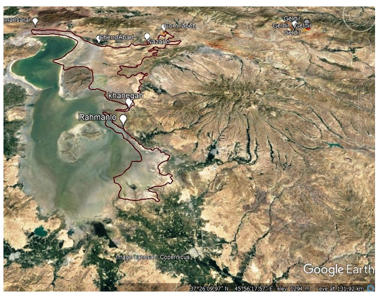
Figure 3. Location of the dust-producing area along the eastern shore of Lake Urmia (East Azerbaijan Province)
Wind Conditions
Due to the vastness of the region and the absence of meteorological stations with long-term data near the dust source, wind and dust conditions were analyzed using synoptic data from Bonab station and climatological data from Tasuj station.
Wind direction and frequency above 6 knots for Bonab and Tasuj stations are shown in Figures 4 and 5. The prevailing wind at Bonab station was easterly, accounting for about 11% of all recorded winds; approximately 3% of these prevailing winds had speeds of 11–16 knots, while 0.5% reached 17–21 knots, and only 0.2% exceeded 21 knots. The second most frequent wind direction was west–southwest (6.3%), followed by east–southeast (6.1%). In both secondary directions, winds of 6–10 knots were dominant.
At Tasuj station, the prevailing wind was northerly, comprising about 9.7% of recorded winds. Among these, 2.5% exceeded 21 knots, 6.2% ranged between 11–16 knots, and 3.2% between 7–10 knots. The second prevailing wind was southerly (8.5%), followed by northeast winds (5.3%). In both cases, winds of 11–16 knots had the highest frequency.
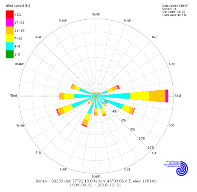
Figure 4. Wind rose at Bonab station for winds exceeding 6 knots (1999–2018)
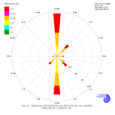
Figure 5. Wind rose at Tasuj station for winds exceeding 6 knots (2000–2018)
Wind tunnel experiments conducted on soil samples collected from East Azerbaijan Province showed that threshold velocities for wind erosion ranged between 8 and more than 13 m/s.
Soil Erodibility
Equations and diagrams illustrating the relationship between wind erosion rates and wind speed indicated that the threshold velocity for soil samples from Gholmansaray–Tasuj was 8 m/s (observed) and 7.85 m/s (calculated).
Dust Hotspots along the Eastern Shore of Lake Urmia
The Qom-Tappeh–Nazarlu and the eastern shoreline of Lake Urmia were identified as the most erosion-prone zones. In the Qom-Tappeh–Nazarlu hotspot, areas west of the Tabriz–Sufiyan road and southeast of Nazarlu village were identified, covering 609 and 243 hectares, respectively.
The most erosion-prone areas along the eastern shore of Lake Urmia extended from the northeast to the southeast. The northeastern shoreline, covering about 5,000 hectares near Shendabad and Gholmansaray villages, was identified as highly sensitive. Further south, lands around Khanqah and Rahmanlu villages, forming a nearly continuous belt enclosing the lake, covered about 46,900 hectares and were ranked as the first-priority sensitive area.
Areas of second and third priority were scattered, consisting of rangelands, orchards, and irrigated farmlands distributed in small patches across both hotspots.
Discussion
The eastern margin of Lake Urmia is part of the desert areas of East Azerbaijan Province and currently overlaps with zones of potential and very severe desertification, particularly in the southeastern and western regions of the province. These findings are consistent with several other studies conducted on Lake Urmia dust phenomena [Nazari Samani et al., 2020; Mardi et al., 2018; Gholampour et al., 2015]. The prevailing wind at the Bonab station originates from the east, accounting for approximately 11% of the recorded winds at this station; about 3% of the dominant winds had a speed of 11–16 knots. Among these, nearly 0.5% reached speeds of 17–21 knots, while winds exceeding 21 knots represented only 0.2% of all recorded winds.
At the Tasuj station, the prevailing wind had a northerly direction, representing 9.7% of the recorded winds. About 2.5% of these dominant winds exceeded 21 knots. Due to its elevated position between the mountains and the lake, Tasuj station recorded significant statistics, with a distribution frequency of 99.9% in three velocity classes: 7–10 knots (35.3%), 11–16 knots (34%), and over 21 knots (30.6%). In contrast, Bonab synoptic station showed that the wind classes of 4–6 knots (58.8%), 7–10 knots (22.5%), and 11–16 knots (15.3%) ranked first to third, respectively, while winds over 21 knots had the lowest frequency (0.7%). These results are in agreement with findings from previous research [Valiallahi et al., 2019; Klingmüller et al., 2016; Shirmohammadi et al., 2020].
The dust source areas along the eastern margin of Lake Urmia including Gholmansaray, Shendabad, Khanqah, Rahmanlu, Bonab, and Malekan consist mainly of low-lying lands with very gentle slopes (0.5%), deep soils with heavy texture, and high salinity. External dust sources also play a major role in increasing the frequency of dust storms in this region. Moreover, the shrinkage of Lake Urmia may influence local climatic conditions [Dehghanipour et al., 2020].
All lands in this region were classified as land unit class 2/6. The vegetation cover was composed of halophytes and salt-tolerant species with moderate density, while most lands remained barren. Salinity and alkalinity levels were high. The decline in the lake’s water level in recent years has caused the drying of shallow and coastal areas. This process, combined with river sedimentation and the formation of deltas and drybeds, facilitated the development of halophytic and herbaceous species in heavily sedimented zones.
The threshold wind velocity for soil erosion in Gholmansaray–Tasuj was observed and calculated as 8 m/s and 7.85 m/s, respectively. The most erosion-prone zones extend along the eastern shore of Lake Urmia, from the northeast to the southeast. In the northeastern part, about 5,000 hectares of land are located near the villages of Shendabad and Gholmansaray. Further south, approximately 46,900 hectares of land adjacent to the villages of Khanqah and Rahmanlu, forming a strip encircling the lake, were identified as the most sensitive to wind erosion. Additional lands classified as sensitivity priorities 2 and 3 are scattered across both dust hotspots, primarily as rangelands, orchards, and irrigated croplands in smaller, fragmented units.
The extensive desiccation of Lake Urmia and the formation of areas highly susceptible to aeolian processes and dust storms have raised national and regional concerns in recent years. Identifying erosion-prone areas and implementing management strategies to control them could alleviate much of this concern. The geomorphological facies around the lake are predominantly composed of saline puffed soils, abandoned lands, and salt-crust surfaces, mainly located in the northeastern, eastern, and southeastern regions. These facies emerged due to the interaction of lake retreat, groundwater level decline, and the formation of new wind-erodible surfaces. Granulometric analyses indicate high deflation potential, particularly in clay-plain facies such as saline puffed soils and salt crusts.
Field evaluations further confirm that the eastern margin of the lake has a high potential for wind erosion and is one of the focal areas where wind erosion control projects are being implemented. Based on sand transport potential analyses, it can be concluded that on an annual scale, the winds in the eastern part of Lake Urmia lack sufficient energy for sediment transport, whereas winds in the western and northwestern parts of the lake are energetic enough to mobilize aeolian sediments.
The control of sand dunes requires the identification of sediment sources in relation to local wind regimes. Since aeolian erosion conditions in this region differ significantly from those in other parts of Iran, particularly the southern coastal and central regions, any erosion control measures must be tailored to the specific ecological and climatic conditions of the study area.
Overall, the results of examining the relationship between the sand mobility index and wind climatic parameters indicate that wind is the most influential climatic factor affecting sand mobility in the study area. Considering the increasing number of dust storm days in the region, which poses a threat to the local environment, climate change has been investigated through the analysis of climatic parameter shifts [Yarahmadi et al., 2015; Ashkenazy et al., 2012]. Previous research on the causes and consequences of changing climatic indices in Iran [Hosseini et al., 2006; Khosroshahi et al., 2009; Yizhaq et al., 2007; Abtahi & Khosrowshahi, 2004; Enssafi Moghadam, 2008; Ghahreman & Bakhtiari, 2009] has similarly highlighted the role of increasing aridity and wind intensity in land degradation and, consequently, more frequent dust events. Although little research has been conducted on sand dune mobility in East Azerbaijan Province, most studies having focused only on Lake Urmia, the findings of this study align with research emphasizing the role of climatic factors, particularly precipitation and wind speed, in exacerbating dust storms [Ebrahimikhusfi et al., 2019; Zandifar et al., 2021; Naemi et al., 2021]. However, they contradict reports of recent sand dune stabilization [Hanifepour et al., 2022], a discrepancy that can be attributed to regional climatic variations and differences in dune management practices.
Conclusion
East Azerbaijan Province contains several sand dune formations that have the potential to become sources of dust emission. In the north, east, and southeast of the province, the dried margins of Lake Urmia, covering an approximate area of 228,000 hectares, constitute the largest potential dust source in the region. This dust hotspot mainly consists of rainfed farmlands, abandoned agricultural lands, dried wetland or lakebeds, and degraded rangelands.
Acknowledgments: None reported by the authors.
Ethical Permission: None reported by the authors.
Conflict of Interest: None reported by the authors.
Authors’ Contributions: Behrawan H (First Author), Methodologist/Statistical Analyst/Main Researcher/Discussion Writer (80%); Yarahmadi J (Second Author), Introduction Writer (10%); Abbasi H (Third Author), Methodologist (10%)
Funding: None reported by the authors
Dust storms are among the most serious natural hazards, influencing climate change [An et al., 2018; Schepanski, 2018; Salehi et al., 2019], marine ecosystems [Bali et al., 2019], snow cover and glaciers [Kutuzov et al., 2019], vegetation, visibility, solar power plants, wildlife [Naji & Taherpour, 2019], as well as various aspects of human health and livelihood [Ardon-Dryer et al., 2020; Opp et al., 2021]. Dust particles represent the heaviest atmospheric aerosols and are attracted to synoptic-scale phenomena such as El Niño [Li et al., 2021; Labban & Butt, 2021]. In addition, dust storms directly affect vegetation [Ebrahimi Khusfi et al., 2020; Hossein Hamzeh et al., 2022], soil texture, and precipitation rates [Dar et al., 2022].
Deserts constitute the largest source of global dust storms [Middleton, 2017]. However, several desiccated lakes have recently emerged as significant new sources of dust worldwide. Numerous dried lakebeds are found across the Middle East and Central Asia. Among them, the Aral Sea, located between Kazakhstan and Uzbekistan [Karami et al., 2021; Opp et al., 2017], is one of the most well-known examples. The Hamoun Lakes in Iran’s Sistan region [Miri et al., 2021] and Lake Urmia in northwestern Iran [Mardi et al., 2018; Boroughani et al., 2019] also represent major dust sources. The chemical composition and grain size of suspended particles lifted from desiccated lakebeds differ considerably from desert-originated dust storms and most saline storms emerging from dried lakes [Opp et al., 2017]. Salt aerosols tend to remain airborne for extended periods [Liu et al., 2011].
Over the past two decades, dust from Lake Urmia has increasingly affected adjacent areas. The frequency of dust events has shown a significant inverse correlation with the lake’s extent [Opp et al., 2017], as its exposed bed is one of the largest saline dust sources in Iran. The lake’s water storage capacity has dramatically declined in recent years, resulting in more frequent saline dust storms. Although climatic factors have contributed to Lake Urmia’s shrinkage, long-term analyses highlight that anthropogenic impacts on its watershed have played a more decisive role in its desiccation [Alizade Govarchin Ghale et al., 2018]. Based on a 40-year analysis, Delju et al. [2013] reported a 9% decrease in precipitation over the lake coupled with an increase of 0.8°C in mean maximum surface temperature. Human-induced drivers are estimated to account for nearly 80% of Lake Urmia’s desiccation, while climatic factors contribute about 20% [Ahmady-Birgani et al., 2020]. Dam construction, agricultural irrigation, and the establishment of a transportation route across the lake are identified as primary anthropogenic causes [Hassanzadeh et al., 2012].
A similar catastrophe occurred in the Aral Sea, which since the 1990s has become one of the most severe environmental disasters in Central Asia [Singer et al., 2003; Indoitu et al., 2015]. Over the past three decades, the Aral Sea has evolved into a major dust source and salt hotspot within the Aralkum Desert, formed on its dried seabed. Both water bodies and vegetation in the basin have declined dramatically, while dust and salt storms have substantially increased [Kochkarova & Mambetullaeva, 2020]. These storms predominantly affect Kazakhstan, Uzbekistan, and Turkmenistan, though in recent years they have also reached northeastern Iran, Tajikistan, and Afghanistan [Singer et al., 2003]. The primary causes of the lake’s water loss are expansion of irrigated croplands, particularly cotton, as the dominant crop, rising water withdrawals from its tributaries, and rapid population growth in surrounding regions [Soudi et al., 2017].
The present study aims to identify and analyze dust and particulate matter sources in East Azerbaijan Province, Iran, and to characterize the properties of these lands. The main stages of the study involved identifying dust-generating zones, determining their general characteristics, measuring and monitoring dust and aeolian sediment production, and delineating the major and sensitive dust-producing areas within East Azerbaijan Province.
Methodology
Identification of Dust-Generating Areas
Several approaches were employed to identify dust emission sources:
- Analysis of wind data: By utilizing wind statistics (direction and velocity) obtained from meteorological stations with adequate records, and by calculating potential sand transport indices for the final transport of aeolian sediments, the characteristics of erosive winds were identified.
- Identification of dust emission sources: Using the data derived from step 1, combined with the sand dune maps (from the National Sand Dune Project) and considering the geomorphology of sandy landforms, the spatial extent of dust sources was delineated. In addition, satellite imagery was employed to refine the boundaries of dust-generating zones.
Figure 1. Locations of soil sampling sites in East Azerbaijan Province
Measurement and Monitoring of Dust and Aeolian Sediment Production
- On-site measurement at dust source areas
Furthermore, to develop a suitable geostatistical model, the wind erosion threshold was determined using a wind tunnel experiment on intact soil samples placed in tray-shaped containers (30 × 50 × 5 cm). The quantity of aeolian sediments generated from each representative land unit was measured using specially designed sediment collectors at wind velocities of 5, 10, 15, 20, and 25 m/s within the wind tunnel.
- Measurement of threshold velocity and wind erosion intensity using a wind tunnel
Figure 2. The wind tunnel used in this study
The threshold velocity was computationally determined by measuring soil loss at varying wind speeds. Using the regression equation of soil loss versus wind speed, the threshold velocity was defined as the point at which soil loss approaches zero.
Equation (1)
(kg m-2 min-1)
Findings
Results of Sand Dune Mobility
Calculations of sand dune mobility were performed only for meteorological stations located in the vicinity of dune fields. In this study, dune fields across the province were identified through field surveys and literature review. Subsequently, sand dune mobility was calculated using the Lancaster method.
Results of Aridity Index and Desertification Risk
The spatial distribution of desertification risk based on the UNEP index was generated in a GIS environment. A large portion of the province falls within the “severe risk” class, while “very severe risk” areas were concentrated in the western parts of the province, along the shores of Lake Urmia, and in its southeastern regions. Areas with “moderate risk” of desertification were observed only in parts of Varzeqan County (Arasbaran), in the northern part of the province.
Dust-Generating Zone along the Eastern Shore of Lake Urmia
The eastern shore of Lake Urmia is part of the desert areas of East Azerbaijan Province, currently overlapping with zones of potential and very severe desertification, particularly in the southeastern and western parts of the province. Using Google Earth imagery (KML files), barren lands, salt flats, and desiccated coastal zones along the eastern margin of the lake were mapped, totaling 227,656 hectares. These areas potentially act as major dust sources during dry seasons. Figure 3 illustrates the current condition of these lands.
Figure 3. Location of the dust-producing area along the eastern shore of Lake Urmia (East Azerbaijan Province)
Wind Conditions
Due to the vastness of the region and the absence of meteorological stations with long-term data near the dust source, wind and dust conditions were analyzed using synoptic data from Bonab station and climatological data from Tasuj station.
Wind direction and frequency above 6 knots for Bonab and Tasuj stations are shown in Figures 4 and 5. The prevailing wind at Bonab station was easterly, accounting for about 11% of all recorded winds; approximately 3% of these prevailing winds had speeds of 11–16 knots, while 0.5% reached 17–21 knots, and only 0.2% exceeded 21 knots. The second most frequent wind direction was west–southwest (6.3%), followed by east–southeast (6.1%). In both secondary directions, winds of 6–10 knots were dominant.
At Tasuj station, the prevailing wind was northerly, comprising about 9.7% of recorded winds. Among these, 2.5% exceeded 21 knots, 6.2% ranged between 11–16 knots, and 3.2% between 7–10 knots. The second prevailing wind was southerly (8.5%), followed by northeast winds (5.3%). In both cases, winds of 11–16 knots had the highest frequency.
Figure 4. Wind rose at Bonab station for winds exceeding 6 knots (1999–2018)
Figure 5. Wind rose at Tasuj station for winds exceeding 6 knots (2000–2018)
Wind tunnel experiments conducted on soil samples collected from East Azerbaijan Province showed that threshold velocities for wind erosion ranged between 8 and more than 13 m/s.
Soil Erodibility
Equations and diagrams illustrating the relationship between wind erosion rates and wind speed indicated that the threshold velocity for soil samples from Gholmansaray–Tasuj was 8 m/s (observed) and 7.85 m/s (calculated).
Dust Hotspots along the Eastern Shore of Lake Urmia
The Qom-Tappeh–Nazarlu and the eastern shoreline of Lake Urmia were identified as the most erosion-prone zones. In the Qom-Tappeh–Nazarlu hotspot, areas west of the Tabriz–Sufiyan road and southeast of Nazarlu village were identified, covering 609 and 243 hectares, respectively.
The most erosion-prone areas along the eastern shore of Lake Urmia extended from the northeast to the southeast. The northeastern shoreline, covering about 5,000 hectares near Shendabad and Gholmansaray villages, was identified as highly sensitive. Further south, lands around Khanqah and Rahmanlu villages, forming a nearly continuous belt enclosing the lake, covered about 46,900 hectares and were ranked as the first-priority sensitive area.
Areas of second and third priority were scattered, consisting of rangelands, orchards, and irrigated farmlands distributed in small patches across both hotspots.
Discussion
The eastern margin of Lake Urmia is part of the desert areas of East Azerbaijan Province and currently overlaps with zones of potential and very severe desertification, particularly in the southeastern and western regions of the province. These findings are consistent with several other studies conducted on Lake Urmia dust phenomena [Nazari Samani et al., 2020; Mardi et al., 2018; Gholampour et al., 2015]. The prevailing wind at the Bonab station originates from the east, accounting for approximately 11% of the recorded winds at this station; about 3% of the dominant winds had a speed of 11–16 knots. Among these, nearly 0.5% reached speeds of 17–21 knots, while winds exceeding 21 knots represented only 0.2% of all recorded winds.
At the Tasuj station, the prevailing wind had a northerly direction, representing 9.7% of the recorded winds. About 2.5% of these dominant winds exceeded 21 knots. Due to its elevated position between the mountains and the lake, Tasuj station recorded significant statistics, with a distribution frequency of 99.9% in three velocity classes: 7–10 knots (35.3%), 11–16 knots (34%), and over 21 knots (30.6%). In contrast, Bonab synoptic station showed that the wind classes of 4–6 knots (58.8%), 7–10 knots (22.5%), and 11–16 knots (15.3%) ranked first to third, respectively, while winds over 21 knots had the lowest frequency (0.7%). These results are in agreement with findings from previous research [Valiallahi et al., 2019; Klingmüller et al., 2016; Shirmohammadi et al., 2020].
The dust source areas along the eastern margin of Lake Urmia including Gholmansaray, Shendabad, Khanqah, Rahmanlu, Bonab, and Malekan consist mainly of low-lying lands with very gentle slopes (0.5%), deep soils with heavy texture, and high salinity. External dust sources also play a major role in increasing the frequency of dust storms in this region. Moreover, the shrinkage of Lake Urmia may influence local climatic conditions [Dehghanipour et al., 2020].
All lands in this region were classified as land unit class 2/6. The vegetation cover was composed of halophytes and salt-tolerant species with moderate density, while most lands remained barren. Salinity and alkalinity levels were high. The decline in the lake’s water level in recent years has caused the drying of shallow and coastal areas. This process, combined with river sedimentation and the formation of deltas and drybeds, facilitated the development of halophytic and herbaceous species in heavily sedimented zones.
The threshold wind velocity for soil erosion in Gholmansaray–Tasuj was observed and calculated as 8 m/s and 7.85 m/s, respectively. The most erosion-prone zones extend along the eastern shore of Lake Urmia, from the northeast to the southeast. In the northeastern part, about 5,000 hectares of land are located near the villages of Shendabad and Gholmansaray. Further south, approximately 46,900 hectares of land adjacent to the villages of Khanqah and Rahmanlu, forming a strip encircling the lake, were identified as the most sensitive to wind erosion. Additional lands classified as sensitivity priorities 2 and 3 are scattered across both dust hotspots, primarily as rangelands, orchards, and irrigated croplands in smaller, fragmented units.
The extensive desiccation of Lake Urmia and the formation of areas highly susceptible to aeolian processes and dust storms have raised national and regional concerns in recent years. Identifying erosion-prone areas and implementing management strategies to control them could alleviate much of this concern. The geomorphological facies around the lake are predominantly composed of saline puffed soils, abandoned lands, and salt-crust surfaces, mainly located in the northeastern, eastern, and southeastern regions. These facies emerged due to the interaction of lake retreat, groundwater level decline, and the formation of new wind-erodible surfaces. Granulometric analyses indicate high deflation potential, particularly in clay-plain facies such as saline puffed soils and salt crusts.
Field evaluations further confirm that the eastern margin of the lake has a high potential for wind erosion and is one of the focal areas where wind erosion control projects are being implemented. Based on sand transport potential analyses, it can be concluded that on an annual scale, the winds in the eastern part of Lake Urmia lack sufficient energy for sediment transport, whereas winds in the western and northwestern parts of the lake are energetic enough to mobilize aeolian sediments.
The control of sand dunes requires the identification of sediment sources in relation to local wind regimes. Since aeolian erosion conditions in this region differ significantly from those in other parts of Iran, particularly the southern coastal and central regions, any erosion control measures must be tailored to the specific ecological and climatic conditions of the study area.
Overall, the results of examining the relationship between the sand mobility index and wind climatic parameters indicate that wind is the most influential climatic factor affecting sand mobility in the study area. Considering the increasing number of dust storm days in the region, which poses a threat to the local environment, climate change has been investigated through the analysis of climatic parameter shifts [Yarahmadi et al., 2015; Ashkenazy et al., 2012]. Previous research on the causes and consequences of changing climatic indices in Iran [Hosseini et al., 2006; Khosroshahi et al., 2009; Yizhaq et al., 2007; Abtahi & Khosrowshahi, 2004; Enssafi Moghadam, 2008; Ghahreman & Bakhtiari, 2009] has similarly highlighted the role of increasing aridity and wind intensity in land degradation and, consequently, more frequent dust events. Although little research has been conducted on sand dune mobility in East Azerbaijan Province, most studies having focused only on Lake Urmia, the findings of this study align with research emphasizing the role of climatic factors, particularly precipitation and wind speed, in exacerbating dust storms [Ebrahimikhusfi et al., 2019; Zandifar et al., 2021; Naemi et al., 2021]. However, they contradict reports of recent sand dune stabilization [Hanifepour et al., 2022], a discrepancy that can be attributed to regional climatic variations and differences in dune management practices.
Conclusion
East Azerbaijan Province contains several sand dune formations that have the potential to become sources of dust emission. In the north, east, and southeast of the province, the dried margins of Lake Urmia, covering an approximate area of 228,000 hectares, constitute the largest potential dust source in the region. This dust hotspot mainly consists of rainfed farmlands, abandoned agricultural lands, dried wetland or lakebeds, and degraded rangelands.
Acknowledgments: None reported by the authors.
Ethical Permission: None reported by the authors.
Conflict of Interest: None reported by the authors.
Authors’ Contributions: Behrawan H (First Author), Methodologist/Statistical Analyst/Main Researcher/Discussion Writer (80%); Yarahmadi J (Second Author), Introduction Writer (10%); Abbasi H (Third Author), Methodologist (10%)
Funding: None reported by the authors
Keywords:
References
1. Abtahi SM, Khosrowshahi M (2004). Desert domian in Esfahan province by climatological factors. Iranian Journal of Range and Desert Research. 12(3):249-262. [Persian] [Link]
2. Ahmady-Birgani H, Ravan P, Schlosser JS, Cuevas-Robles A, AzadiAghdam M, Sorooshian A (2020). On the chemical nature of wet deposition over a major desiccated lake: Case study for Lake Urmia basin. Atmospheric Research. 234:104762. [Link] [DOI:10.1016/j.atmosres.2019.104762]
3. Alizade Govarchin Ghale Y, Altunkaynak A, Unal A (2018). Investigation anthropogenic impacts and climate factors on drying up of Urmia Lake using water budget and drought analysis. Water Resources Management. 32:325-337. [Link] [DOI:10.1007/s11269-017-1812-5]
4. An L, Che H, Xue M, Zhang T, Wang H, Wang Y, et al (2018). Temporal and spatial variations in sand and dust storm events in East Asia from 2007 to 2016: Relationships with surface conditions and climate change. Science of the Total Environment. 633:452-462. [Link] [DOI:10.1016/j.scitotenv.2018.03.068]
5. Ardon-Dryer K, Mock C, Reyes J, Lahav G (2020). The effect of dust storm particles on single human lung cancer cells. Environmental Research. 181:108891. [Link] [DOI:10.1016/j.envres.2019.108891]
6. Ashkenazy Y, Yizhaq H, Tsoar H (2012). Sand dune mobility under climate change in the Kalahari and Australian deserts. Climatic Change. 112(3):901-923. [Link] [DOI:10.1007/s10584-011-0264-9]
7. Bali K, Mishra AK, Singh S, Chandra S, Lehahn Y (2019). Impact of dust storm on phytoplankton bloom over the Arabian Sea: A case study during March 2012. Environmental Science and Pollution Research. 26:11940-11950. [Link] [DOI:10.1007/s11356-019-04602-7]
8. Boroughani M, Hashemi H, Hosseini SH, Pourhashemi S, Berndtsson R (2019). Desiccating Lake Urmia: A new dust source of regional importance. IEEE Geoscience and Remote Sensing Letters, 17(9):1483-1487. [Link] [DOI:10.1109/LGRS.2019.2949132]
9. Dar MA, Ahmed R, Latif M, Azam M (2022). Climatology of dust storm frequency and its association with temperature and precipitation patterns over Pakistan. Natural Hazards. 110(1):655-677. [Link] [DOI:10.1007/s11069-021-04962-9]
10. Dehghanipour AH, Moshir Panahi D, Mousavi H, Kalantari Z, Tajrishy M (2020). Effects of water level decline in Lake Urmia, Iran, on local climate conditions. Water. 12(8):2153. [Link] [DOI:10.3390/w12082153]
11. Delju AH, Ceylan A, Piguet E, Rebetez M (2013). Observed climate variability and change in Urmia Lake Basin, Iran. Theoretical and Applied Climatology. 111:285-296. [Link] [DOI:10.1007/s00704-012-0651-9]
12. Ebrahimi Khusfi Z, Khosroshahi M, Roustaei F, Mirakbari M (2020). Spatial and seasonal variations of sand-dust events and their relation to atmospheric conditions and vegetation cover in semi-arid regions of central Iran. Geoderma. 365:114225. [Link] [DOI:10.1016/j.geoderma.2020.114225]
13. Ebrahimikhusfi Z, Khosroshahi M, Naeimi M, Zandifar S (2019). Evaluating and monitoring of moisture variations in Meyghan wetland using the remote sensing technique and the relation to the meteorological drought indices. Journal of RS and GIS for Natural Resources. 10(2):1-14. [Persian] [Link]
14. Enssafimoghadam T (2008). An Investigation and assessment of climatological indices and determination of suitable index for climatological droughts in the Salt Lake Basin of Iran. Iranian Journal of Range and Desert Research. 14(2):271-288. [Persian] [Link]
15. Ghahreman N, Bakhtiari B (2009). Solar radiation estimation from rainfall and temperature data in arid and semi-arid climates of Iran. Desert. 14(2):141-150. [Link]
16. Gholampour A, Nabizadeh R, Hassanvand MS, Taghipour H, Nazmara S, Mahvi AH (2015). Characterization of saline dust emission resulted from Urmia Lake drying. Journal of Environmental Health Science and Engineering. 13:1-11. [Link] [DOI:10.1186/s40201-015-0238-3]
17. Hanifepour M, Biabani L, Khosravi H, Akbarpoor Bonab B (2022). Monitoring and forecasting of climatic factors affecting the mobility of sand dunes using Lancaster index (Case study: Sirjan desert). Journal of Arid Regions Geographic Studies. 13(48):1-20. [Persian] [Link]
18. Hassanzadeh E, Zarghami M, Hassanzadeh Y (2012). Determining the main factors in declining the Urmia Lake level by using system dynamics modeling. Water Resources Management. 26:129-145. [Link] [DOI:10.1007/s11269-011-9909-8]
19. Hossein Hamzeh N, Ranjbar Saadat Abadi A, Ooi MCG, Habibi M, Schöner W (2022). Analyses of a lake dust source in the Middle East through models performance. Remote Sensing. 14(9):2145 [Link] [DOI:10.3390/rs14092145]
20. Hosseini M, Khosrowshahi M, Attapour A, Karmi SA (2006). Introduction and determination of climatic and geological desert characteristics in Tehran province. Iranian Journal of Range and Desert Research. 13(2):102-108. [Persian] [Link]
21. Indoitu R, Kozhoridze G, Batyrbaeva M, Vitkovskaya I, Orlovsky N, Blumberg D, et al (2015). Dust emission and environmental changes in the dried bottom of the Aral Sea. Aeolian Research. 17:101-115. [Link] [DOI:10.1016/j.aeolia.2015.02.004]
22. Karami S, Hossein Hamzeh N, Kaskaoutis DG, Rashki A, Alam K, Ranjbar A (2021). Numerical simulations of dust storms originated from dried lakes in central and southwest Asia: The case of Aral Sea and Sistan Basin. Aeolian Research. 50:100679 [Link] [DOI:10.1016/j.aeolia.2021.100679]
23. Khosroshahi M, Khashki MT, Ensafi Moghaddam T (2009). Determination of climatological deserts in Iran. Iranian Journal of Range and Desert Research. 16(1):96-113. [Persian] [Link]
24. Klingmüller K, Pozzer A, Metzger S, Stenchikov GL, Lelieveld J (2016). Aerosol optical depth trend over the Middle East. Atmospheric Chemistry and Physics. 16(8):5063-5073. [Link] [DOI:10.5194/acp-16-5063-2016]
25. Kochkarova S, Mambetullaeva S (2020). Study of successional processes of Vegetation cover on the dried seabed of the Aral Sea. Journal Research on the Lepidoptera. 51:764-768. [Link] [DOI:10.36872/LEPI/V51I1/301071]
26. Kutuzov S, Legrand M, Preunkert S, Ginot P, Mikhalenko V, Shukurov K, et al (2019). The Elbrus (Caucasus, Russia) ice core record-Part 2: History of desert dust deposition. Atmospheric Chemistry and Physics. 19(22):14133-14148. [Link] [DOI:10.5194/acp-19-14133-2019]
27. Labban AH, Butt MJ (2021). Analysis of sand and dust storm events over Saudi Arabia in relation with meteorological parameters and ENSO. Arabian Journal of Geosciences. 14:1-12. [Link] [DOI:10.1007/s12517-020-06291-w]
28. Li J, Garshick E, Huang S, Koutrakis P (2021). Impacts of El Niño-Southern Oscillation on surface dust levels across the world during 1982-2019. Science of the Total Environment. 769:144566. [Link] [DOI:10.1016/j.scitotenv.2020.144566]
29. Liu D, Abuduwaili J, Lei J, Wu G (2011). Deposition rate and chemical composition of the aeolian dust from a bare saline playa, Ebinur Lake, Xinjiang, China. Water, Air, & Soil Pollution. 218:175-184. [Link] [DOI:10.1007/s11270-010-0633-4]
30. Mardi AH, Khaghani A, MacDonald AB, Nguyen P, Karimi N, Heidary P, et al (2018). The Lake Urmia environmental disaster in Iran: A look at aerosol pollution. Science of The Total Environment. 633:42-49. [Link] [DOI:10.1016/j.scitotenv.2018.03.148]
31. Middleton NJ (2017). Desert dust hazards: A global review. Aeolian Research. 24:53-63. [Link] [DOI:10.1016/j.aeolia.2016.12.001]
32. Miri A, Maleki S, Middleton N (2021). An investigation into climatic and terrestrial drivers of dust storms in the Sistan region of Iran in the early twenty-first century. Science of the Total Environment. 757:143952. [Link] [DOI:10.1016/j.scitotenv.2020.143952]
33. Naemi M, Zandifar S, Khosroshahi M, Ashoori P, Abbasi H (2021). Investigating the effects of climate change on the mobility of sand dunes (case study: Sabzevar city). Desert Management. 9(2):1-18. [Persian] [Link]
34. Naji H, Taherpour M (2019). The effect of simulated dust storm on wood development and leaf stomata in Quercus brantii L. Desert. 24(1):43-49. [Link]
35. Nazari Samani A, Rahdari MR, Rahi G (2020). Assessment of spatial variabilities of soil erodibility by wind on margial lands of the Lake Urmia. Desert Management. 8(15):53-72. [Persian] [Link]
36. Opp C, Groll M, Abbasi H, Ahmadi Foroushani M (2021). Causes and effects of sand and dust storms: What has past research taught us? A survey. Journal of Risk and Financial Management. 14(7):326. [Link] [DOI:10.3390/jrfm14070326]
37. Opp C, Wagemann J, Banedjshafi S, Abbasi HR (2017). Aral Sea syndrome and Lake Urmia crisis. A comparison of causes, effects and strategies for problem solutions. Academic Research. 34:169-83. [Link]
38. Salehi S, Ardalan A, Ostadtaghizadeh A, Garmaroudi G, Zareiyan A, Rahimiforoushani A (2019). Conceptual definition and framework of climate change and dust storm adaptation: A qualitative study. Journal of Environmental Health Science and Engineering. 17:797-810. [Link] [DOI:10.1007/s40201-019-00396-5]
39. Schepanski K (2018). Transport of mineral dust and its impact on climate. Geosciences. 8(5):151. [Link] [DOI:10.3390/geosciences8050151]
40. Shirmohammadi B, Malekian A, Salajegheh A, Taheri B, Azarnivand H, Malek Z, et al (2020). Scenario analysis for integrated water resources management under future land use change in the Urmia Lake region, Iran. Land Use Policy. 90:104299. [Link] [DOI:10.1016/j.landusepol.2019.104299]
41. Singer A, Zobeck T, Poberezsky L, Argaman E (2003). The PM10 and PM2·5 dust generation potential of soils/sediments in the Southern Aral Sea Basin, Uzbekistan. Journal of Arid Environments. 54(4):705-728. [Link] [DOI:10.1006/jare.2002.1084]
42. Soudi M, Ahmadi H, Yasi M, Hamidi SA (2017). Sustainable restoration of the Urmia Lake: History, threats, opportunities and challenges. European Water. 60:341-347. [Link]
43. Valiallahi J, Soltani A, Ahmadi Eghbal M (2019). Evaluating climate change and anthropogenic effects on inducing Salt storms & aerosol hazards risk in Urmia Lake. Anthropogenic Pollution. 3(1):25-32. [Persian] [Link]
44. Yarahmadi D, Nasiri B, Khushkish A, Nikbakht H (2015). Climate change and dusty days in the west and southwest of Iran. Desert Ecosystem Engineering. 3(5):19-28. [Persian] [Link]
45. Yizhaq H, Ashkenazy Y, Tsoar H (2007). Why do active and stabilized dunes coexist under the same climatic conditions? Physical Review Letters. 98(18):98-101. [Link] [DOI:10.1103/PhysRevLett.98.188001]
46. Zandifar S, Khosroshahi M, Ebrahimikhusfi Z, Naeimi M (2021). Using Lancaster index to analyse of the sand dunes activity in arid lands and sensitivity analysis of the factors affecting it (case study: Buin-Zahra city). Desert Management. 8(16):1-16. [Persian] [Link]